Barranquitas: Barranquitas, Puerto Rico
Barranquitas, Puerto Rico
(bahr-rahn-KEE-tahs)
Barranquitas is known as La Cuna de Próceres (cradle of great
people). The town was founded in 1803 by Antonio Aponte Ramos.
Luis Muñoz Rivera former home has been converted into a museum and
library. Nearby, the Mausoleo Familia Muoz Rivera holds the bodies of Muñoz
Rivera and his son Luis Muñoz Marín, the island’s first elected governor.
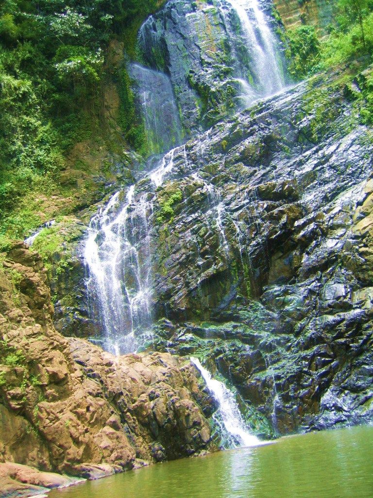
Barranquitas is home to the largest canyon in Puerto Rico (and in the Caribbean), the San Cristóbal
Canyon. Located between the towns of Aibonito and
Barranquitas, the canyon is nine kilometers long and
approximately 750 feet deep, with two rivers flowing through it,
the Usabon and Barranquitas rivers. It is also home to the highest waterfall in Puerto Rico, right on the
Río Usabón. Guided hiking trips are available, for more information, call the San Cristobal Hiking Tour
at: (787) 857-2094 or (787) 647-3402.
Additional Places and Sights
Other places worth exploring include:
- Museo Casa Natal de Luis Munoz Rivera, Open Fri-Sun 8:00am-noon 1:00pm-4:30pm, (787) 857-0230
- Munoz Marin Mausoleum, Open daily 8:00am-noon 1:00pm-4:30pm, (787) 857-3810
Economy
The surrounding areas produce coffee, fruits and flowers.
Geography
Barranquitas is located in the central region,
north of Aibonito and
Coamo;
south of Corozal and
Naranjito;
east of Orocovis; and west of
Comerío.
Barranquitas rivers include Piñonas, Usabón, Rio Hondo, Barranquitas, La
Plata and Grande de Manatí rivers.
Aibonito is made up of 8 barrios (wards/districts):
- Barrancas
- Cañabón
- Helechal y Honduras
- Palo Hincado
- Quebrada
- Grande,
- Pueblo
- Quebradillas
Rivers
Rio de Barranquitas, Rio Grande de Manati, Río de la Plata, Piñonas, Río Hondo, and Río Usabón.
Climate
Barranquitas annual precipiation is 34.45 inches and its average temperature is 83deg;F.
August is on average the warmest month, at around 83°F.
January is on average the coolest month, at around 77°F.
10 Day Forecast
Notable People
There are many well-known “barranquiteños”, among them:
politician Luis Muñoz Rivera, Luis Muñoz Marn, José Colón,
Efrain Colón Torres, José A. Negrón Sanjurjo, Antonio Aponte
Ramos, Naldo de la Loma, and Pedro Pereales.
Restaurants
- La Tosca Steak House (Puerto Rican), (787) 857-4288
- Mofongo Criollo (Puerto Rican), (787) 857-0480
- Porkys Restaurant (Puerto Rican), (787) 798-3360
Festivals and Events
- Barranquitas Artisans’ Fair – July
Barranquitas is the center of rich artistic traditions. This fair is the oldest crafts fair features exhibitions by more than 130 artisans from around Puerto Rico. You will find your self surrounded of a variety of handcrafts, paintings, sculptures and more. Daytime and evening musical concerts take place in the town’s plaza.
(787) 857-0520 - Festival de la Vega – May
- Fiestas Patronales de San Antonio de Padua – June
Every year, Barranquitas celebrates a patron saint festival. The festivities include dances, food, parades and religious processions.
(787) 857-2065
 You will find your self surrounded of a variety of handcrafts, paintings, sculptures and more. Daytime and evening musical concerts take place in the town’s plaza.
Symbols
Flag
Coat of Arms
The anthem title is Aquí en el centro de nuestra tierra….
Education
There are 16 public schools in Barranquitas,
education is handled by the Puerto Rico Department of Education.
Barranquitas is also home of 2 colleges and universities.
Demographics *
Population
28,983
Puerto Rico: 3,285,874
Land Area: 34.25 sq mi
Density: 818.2 per sq mi
Median Age: 37. 5
5
Sex: 51% female
Economics **
Per capita income
$9,187
Puerto Rico: $21,058
Median household income: $18,924
Puerto Rico: $21,058
Persons below poverty line: 53%
Housing, families and educational attainment *
Number of households
8,829
Housing units density:
333 (2013)
Persons per household: 3.14
High school grad or higher: 73.8%
Marital status: 38% married
* U.S. Census Bureau 2020 data, unless otherwise noted – Source: Quick Facts Puerto Rico.
** U.S. Census Bureau 2016-2020
Map References
Coordinates: 18.1867° N, 66.3064° W
Zip Code: 794
Driving Distance from San Juan: 40.7 miles
Driving Time: 1 hour, 24 minutes
Barranquitas | Central Mountains | Discover Puerto Rico
Located in Barranquitas, Salto La Vaca is the highest waterfall in Puerto Rico
A mountainside escape from city life.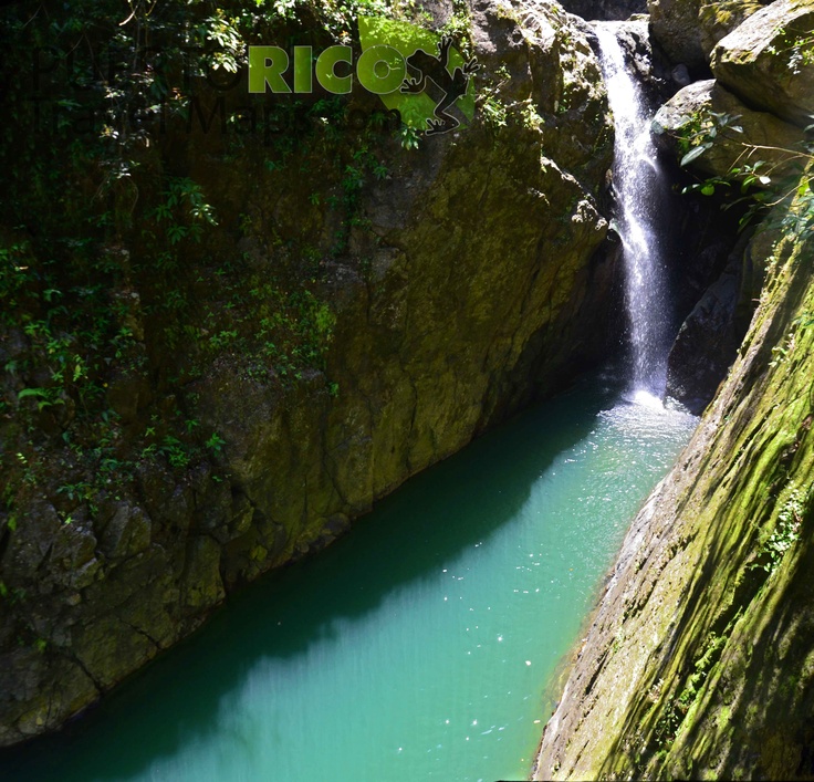
The windy, narrow roads of la Ruta Panorámica lead the way to Barranquitas, a municipality set high in the Cordillera Central mountain range. From flowers and fruit trees to shrubs and ferns, the area offers a bounty of natural beauty. Barranquitas borders Naranjito and Corozal to the north, Coamo and Aibonito to the south, Orocovis to the west, and Comerío and Cidra to the east. It takes about an hour and a half to drive here from San Juan.
Natural Attraction
Along with neighboring Aibonito, Barranquitas offers access to Cañón de San Cristóbal, an awe-inspiring, 5.6-mile (nine-kilometer) canyon. More than 749 species of plants and wildlife can be found here, along with natural pools, rivers, streams, and Salto La Vaca, the highest waterfall in Puerto Rico. The site is managed by environmental non-profit organization Para La Naturaleza, which leads guided educational tours that provide expert insight into the local ecosystem. If you’re looking for a more challenging experience, sign up for a hiking and repelling excursion with Go Hiking PR.
The 1,200-acre Cañón Las Bocas Nature Reserve also offers an opportunity for outdoor exploration. Barranquitas shares this protected area with Comerio, and you can spend the day here amidst exotic flora and fauna, impressive caves and waterfalls, and the vast Cañón Las Bocas.
Plan a Trip along la Ruta Panorámica
Plaza Pública Mons. Miguel Angel Mendoza
A Peek into History
Luis Muñoz Rivera, one of Puerto Rico’s most important political figures (and father to the Island’s first elected governor), hailed from Barranquitas, and the home where he was born is now a museum dedicated to his life and career. Built in 1857, the house features furniture and other items from the time, including Muñoz Rivera’s original desk and a magnificently restored 1912 Pierce-Arrow automobile.
Another historic home that is open to the public belonged to former Barranquitas mayor Joaquín Rojas Martínez. The structure dates back to 1930 and today houses the municipality’s Office of Culture and Tourism.
The Art of Craftsmanship
Thousands of attendees and more than 200 artisans gather in the town square every July for the Feria Nacional de Artesanías de Barranquitas, a three-day crafts festival. In an age of mass production, this artsy event is a reminder of how valuable craftsmanship is to Puerto Rican culture, and it’s the perfect place to buy a one-of-a-kind souvenir directly from the person who made it.
Local Accommodations
Spend the night in Barranquitas at the 11-room Hacienda Margarita, where you can take in sweeping mountain views while relaxing in the outdoor pool. Or book a stay at Canyon Boutique Hotel, which offers simple, clean guest rooms and suites just minutes from restaurants and attractions.
Barrancas Department of Guajira Colombia
The city of Barrancas is located in Colombia, Department of Guajira.
Archived
panoramio
. Photo rights belong to their respective owners
Barrancas on Wikipedia
Barrancas (Spanish: Barrancas) is a city and municipality in the northeast of Colombia, in the department of Guajira. The settlement on the site of the modern city was founded by the Spaniards in 1664. The city is located in the southeastern part of Guajira, in the valley of the Rancheria River (Spanish) (Russian), at a distance of approximately 62 kilometers south-southeast (SSE) of Riohachi, the administrative center of the department. The absolute height is 132 meters above sea level .The area of the municipality is 742 km².According to the National Administrative Department of Statistics of Colombia, the combined population of the city and the municipality in 2012 was 32,254.Dynamics of the city’s population over the years: According to the 2005 census, men accounted for 50.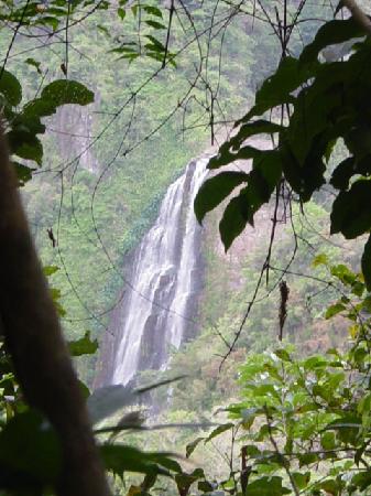 1% of the population of the city , women – respectively 49,9 %. Racially, whites and mestizos made up 70% of the city’s population; Indians – 21.2%; Negroes, mulattoes and Raysalians – 8.8%. The literacy rate among the entire population was 86%.
More details
Nearest settlements near Barrancas
All settlements
Department of Guajira
Hotels in nearby communities
All hotels
Department of Guajira
Photos of Barrancas
Add a photo
Barrancas and
did you take pictures of the city and interesting places?
Post them!
Many visitors to our site take photos on their trips.
Post your photos from
Barrancas and from other cities!
Tag if you’ve seen these places too!
Now it is possible to add from the mobile version of the site,
which makes it much easier to transfer photos from
from smartphones to the site!
Souvenirs from Barrancas
Add Souvenir
Were in
Barrancas and brought souvenirs?
Show them to everyone! Fridge magnets, plates, pennants, mugs and everything you need
bring with you from business trips and trips to
Barrancas!
Post and tag if you already have one!
Post their photo!
From the mobile version of the site, it is much easier to do this and transferring photo magnets from
Barrancas from smartphones to the site will be more convenient!
Last reviews of Barrancas
Add a review
Dear visitors of the website Komandirovka. ru!
ru!
No reviews yet
Write a review!
Last questions about the city
Add a question
If you have questions about this location or are looking for people from
city of Barrancas,
living in it, you can ask ask the appropriate question. We hope that our users will help you with the answers. 9Ol000 +2373
+3391
Th for 3 November
Tomorrow
+2373
+3086
1 00
4 00
7 00 9000 9000 9000 13000 13 00
16 00
19 00
22 00
+2373
+2373
+2577
+3188 9000 +391 9000 +25,000 +25000 +25000 +25000 +25000 +25000 +25000 +25000 +39000 +25000 +25000 +39000 +25000 +25000 +2
+2475
Wind speed, m/skkm/h
1-2 4-7
0-1 0-4
1-2 4-7
2-3 7-11
14-18
3-5 11-18
1-5 4-18
1-5 4-18
Precipitation, mm
print .