Castillo de san felipe el morro: Exploring Castillo San Felipe del Morro in Old San Juan
Castillo San Felipe del Morro: a strategic fortress in San Juan’s harbor
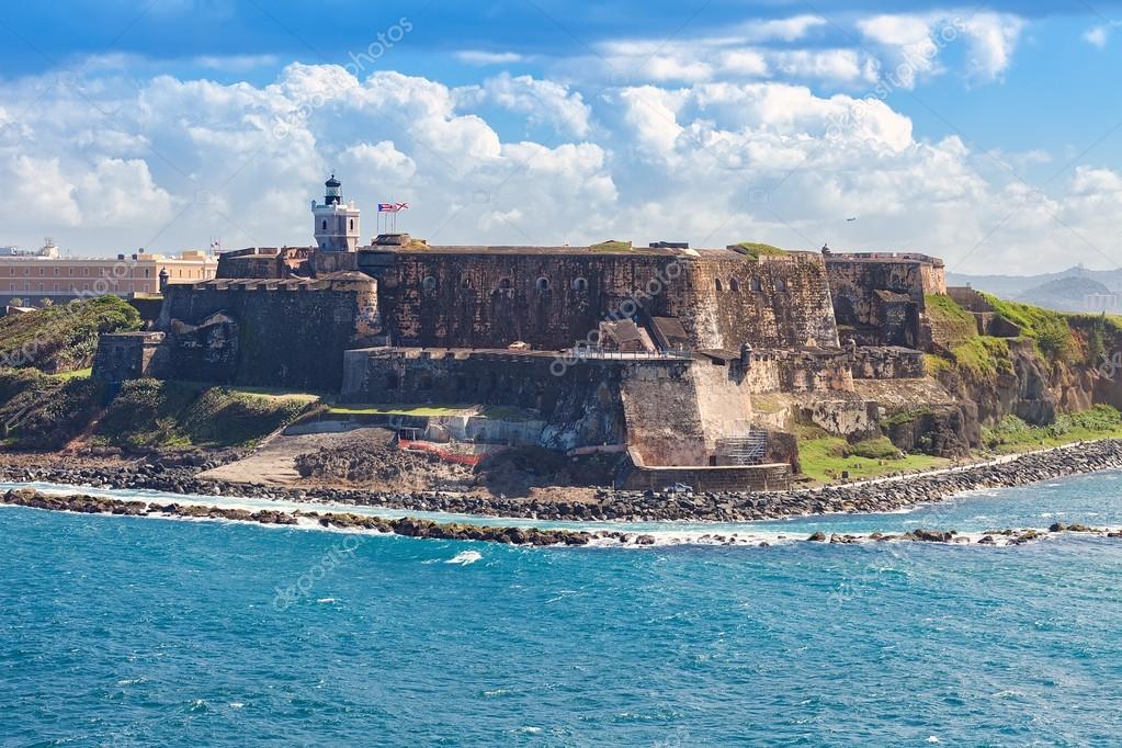
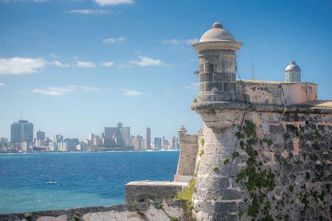
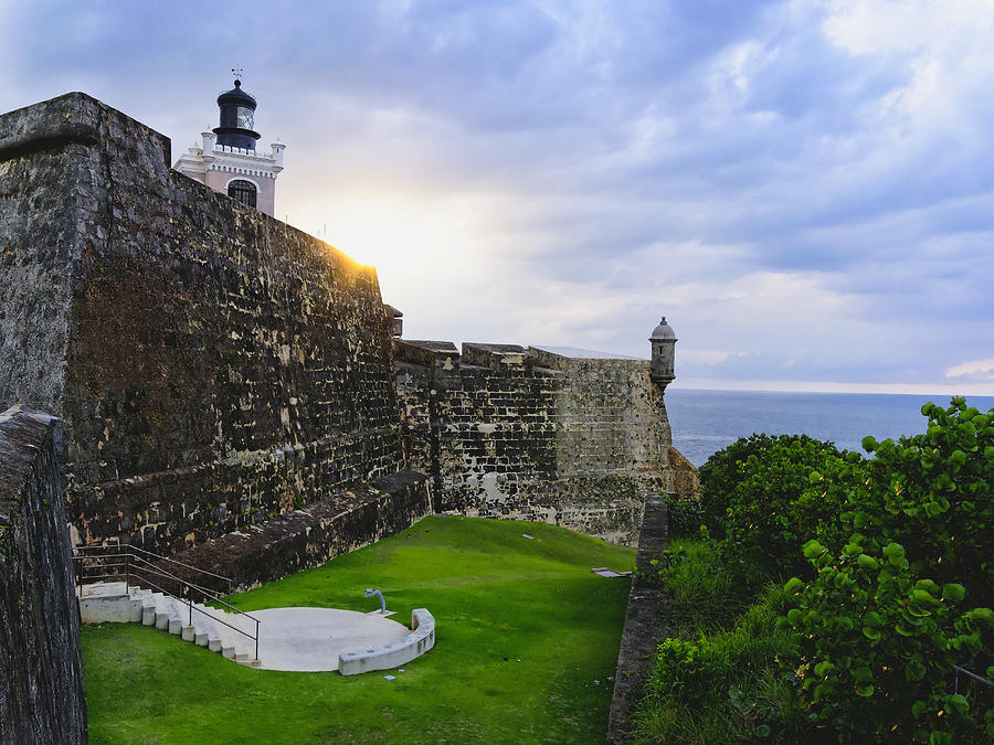
Grounds and Lighthouse at El Morro
Castillo San Felipe del Morro (El Morro) was built by the Spanish to control the entrance to the Caribbean Sea and the gateway to the New World. During the Age of Discovery, the mouth of the channel into San Juan’s harbor was considered a strategic island for military and economic reasons.
The construction took approximately 250 years to complete. Spain responded to potential and future threats by expanding and improving the fort. This San Juan landmark looks very much like it did at the end of the 18th century. History buffs and people who enjoy exploring fortresses should not miss this one. Children are free to roam and explore.
This fortress sits on headland— a high point of land that juts into the water. El Morro means the headland. This prime location provides excellent photo opportunities.
San Juan de la Cruz on Isla de Cabras
Across the channel is a sister fort called San Juan de la Cruz. It is located on the end of the Isla de Cabras. The Spanish built this benign looking structure to create a deadly and effective crossfire.
Anyone who remembers Christopher Columbus’s voyages will recall that he discovered this island. He called the island San Juan Bautista (St. John the Baptist). The name Puerto Rico originally referred to the city and the bay. The names were switched a century later.
In the mid 19th century lighthouses were added to help guide ships. Modern visitors will be drawn to take pictures of them.
Cannon from 18th-19th centuries
The fortress showcases three distinct periods of artillery evolution. In the 18th century, cannons were placed in gun openings or embrasures. Starting in the late 19th century, a semi-circular track of ground bricks was used to support the cannons. Under Spanish rule, cannons were fired at the English, the Dutch, the British and the Americans. During World War II, anti-aircraft guns were positioned on slabs of concrete.
For approximately 400 years, Spain fought hard to control Puerto Rico. They lost control to the US during the Spanish-American War (1898).
During World War I, El Morro was called Fort Brooke. In 1961, the fort became a national historic site under the auspices of the National Park Service.
The National Park System left an open field (esplanade) so that visitors can imagine how the Spanish defenders used the open space to shoot anyone who came to attack them. Today, locals and tourists can enjoy this scenic spot without any fears.
Before You Go
Check the National Park Service website for information about pricing, movies, and tours. Take time to look at the map so that you can plan your route.
On a sunny day, don’t forget to put on sunscreen. It is a good idea to wear comfortable walking shoes, and to bring a hat and sunglasses. An ample supply of water is a necessity, especially if you’re planning to walk between the two fortresses. Castillo San Cristobal is less than a mile away.
THE ABOVE ARTICLE WAS ORIGINALLY PUBLISHED ON MARCH 16, 2016. IT IS BEING REPOSTED ON THIS SITE BECAUSE THE EXAMINER SITE SHUT DOWN IN JULY 2016. SOME PARTS OF THE ORIGINAL ARTICLE HAVE BEEN UPDATED AND THE ORIGINAL SLIDE SHOW HAS BEEN ELIMINATED.
RELATED BLOGS
Kotor, Montenegro—a land and sea adventure
Dubrovnik—a walkable coastal town
The Tower of Hercules
Castelo de S. Jorge: historical Lisbon castle with stunning views
Teide National Park—a lunar like adventure
Spanish Port—exploring Vigo
BIO
Sandra Bornstein is a freelance travel writer. She shares her travel experiences and recommendations on this blog and on other websites—One Travel: Going Places, Cheapoair.com Miles Away Travel Blog, We Said Go Travel, Mom It Forward, Boulder Jewish News, and Family Circle. Her travel tips also appear in the Denver metro magazine, Golden Living.
Sandra is the author of MAY THIS BE THE BEST YEAR OF YOUR LIFE.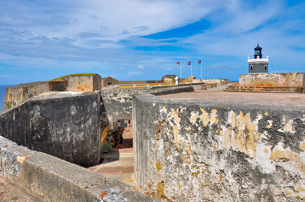 This memoir highlights Sandra’s living and teaching adventure in Bangalore, India. She is a licensed Colorado teacher who has taught K-12 students in the United States and abroad as well as college level courses. Sandra is married and has four adult sons.
The memoir was a finalist in the Travel category for the 2013 Next Generation Indie Book Awards, the 2013 International Book Awards, the 2013 National Indie Book Excellence Awards, 2013 USA Best Book Awards, and a Honorable Mention award in the Multicultural Non-Fiction category for the 2013 Global ebook Awards.
Isla Verde Beach to Castillo San Felipe del Morro
Find Transport to Castillo San Felipe del Morro
Travel From
Travel From
To
Search accommodation with Booking. com
com
Need a hotel room in San Juan?
Book now
There are 3 ways to get from Isla Verde Beach to Castillo San Felipe del Morro by taxi, car or shuttle
Select an option below to see step-by-step directions and to compare ticket prices and travel times in Rome2rio’s travel planner.
Taxi
• 15 min
-
Take a taxi from Isla Verde Beach to Castillo San Felipe del Morro
13.2 km
Drive
• 15 min
-
Drive from Isla Verde Beach to Castillo San Felipe del Morro
13. 2 km
2 km
 2 km
2 km
Shuttle
• 31 min
-
Take a shuttle bus from San Juan Airport to Decanter Hotel, San Juan
Quickest way to get there
Cheapest option
Distance between
Coronavirus (COVID-19) in Puerto Rico
There is widespread community transmission globally.
We have received no reports of travel restrictions in Puerto Rico. For the latest travel status, please check the official page for Puerto Rico.
For travel planning advice, please refer to our Rome2rio Coronavirus information page .
For the latest travel status, we recommend checking the official page for Puerto Rico.
Coronavirus (COVID-19) Travel Advice
Can I travel internationally to Castillo San Felipe del Morro?
Currently, we are unable to provide international travel restriction information for Puerto Rico relating to Coronavirus (COVID-19). For the latest travel status in Puerto Rico, please check government recommendations.
Official Coronavirus (COVID-19) Information for Puerto Rico
Can I travel domestically within Puerto Rico?
Currently, we are unable to provide domestic travel restriction information for travelling within Puerto Rico. For the latest Coronavirus (COVID-19) travel status within Puerto Rico, please check government recommendations.
Official Coronavirus (COVID-19) Information for Puerto Rico
Are there restrictions on leaving Puerto Rico?
Currently, we are unable to provide travel restriction information for leaving Puerto Rico.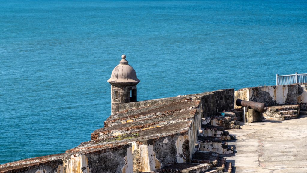 For the latest Coronavirus (COVID-19) travel status in Puerto Rico, please check government recommendations.
Official Coronavirus (COVID-19) Information for Puerto Rico
Last updated: December 8 | Data sourced from: ACAPS, OXFORD
Questions & Answers
What is the cheapest way to get from Isla Verde Beach to Castillo San Felipe del Morro?
The cheapest way to get from Isla Verde Beach to Castillo San Felipe del Morro is to drive which costs €1 – €2 and takes 15 min.
More details
What is the fastest way to get from Isla Verde Beach to Castillo San Felipe del Morro?
The quickest way to get from Isla Verde Beach to Castillo San Felipe del Morro is to taxi which costs €35 – €45 and takes 15 min.
More details
How far is it from Isla Verde Beach to Castillo San Felipe del Morro?
The distance between Isla Verde Beach and Castillo San Felipe del Morro is 12 km. The road distance is 13.2 km.
Get driving directions
How do I travel from Isla Verde Beach to Castillo San Felipe del Morro without a car?
The best way to get from Isla Verde Beach to Castillo San Felipe del Morro without a car is to taxi which takes 15 min and costs €35 – €45.
More details
How long does it take to get from Isla Verde Beach to Castillo San Felipe del Morro?
It takes approximately 15 min to drive 13.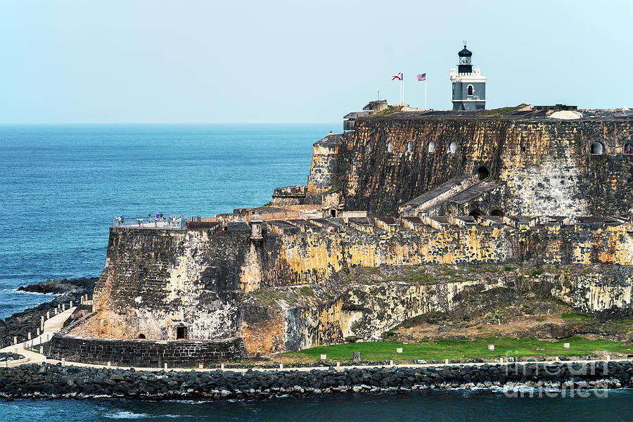 2 km from Isla Verde Beach to Castillo San Felipe del Morro.
More details
Can I drive from Isla Verde Beach to Castillo San Felipe del Morro?
Yes, the driving distance between Isla Verde Beach to Castillo San Felipe del Morro is 13 km. It takes approximately 15 min to drive from Isla Verde Beach to Castillo San Felipe del Morro.
Get driving directions
Where can I stay near Castillo San Felipe del Morro?
There are 519+ hotels available in Castillo San Felipe del Morro. Prices start at €87 per night.
More details
What companies run services between Isla Verde Beach, Puerto Rico and Castillo San Felipe del Morro, Puerto Rico?
You can catch a taxi from Isla Verde Beach to Castillo San Felipe del Morro with Puerto Rico Taxi, Michael’s Taxi Service, Santana Taxi Service, Rochdale Radio Taxi or Metro Taxi.
GO Puerto Rico Shuttle
- Phone
- (787) 400-2100
- [email protected]
- Website
- puertoricoshuttle.com
- Ave. Duration
- 20 min
- Frequency
- On demand
- Estimated price
- €57
- Schedules at
- puertoricoshuttle.com
- Book at
- puertoricoshuttle. com
 com
com
Taxi from Isla Verde Beach to Castillo San Felipe del Morro
- Ave. Duration
- 15 min
- Estimated price
- €35 – €45
- Phone
- +1 787-969-3260
- Phone
- +1 787-661-9694
- Phone
- +787 562-9836
- Website
- santanataxi.webs.com
- Phone
- +787 721-1900
- Website
- taxiprrochdale. com
 com
com
- Phone
- +787 725-2870
- Website
- boricuataxi.com
Want to know more about travelling around the world?
Rome2rio’s Travel Guide series provide vital information for the global traveller. Read our range of informative guides on popular transport routes and companies – including Travelling to the US: What do I need to know?, How to get from Stansted Airport into central London and Travelling around the UAE – to help you get the most out of your next trip.
El Morro Castle – PICRYL Public domain image
[St. Jean de Luz, Fort Socoa, Pyrenees, France]
St.
 Jean de Luz, Fort Socoa, Pyrenees, France-LCCN2001698674
St. Jean de Luz, Fort Socoa, Pyrenees, France-LCCN2001698674
Vista de Sitges des del cementiri
Road to golf links & lighthouse, North Truro, Mass.
Cuba. Morro Castle, Havana, from harbor
Marconi Telegraph Station & Poldhu Hotel, Helston (NBY 442278)
Forty Steps, Cliff Walk, Newport, R.
 I (NYPL b12647398-66771)
Entrance to harbor, Scituate, Mass.
Havana, Morro Castle
Castillo del Morro, Habana view, photochrome print postcard.
Castillo del Morro, Habana. Photochrom print, 1880-1890.
Morro Castle, Havana, Cuba
Morro Castle, Havana, Cuba
Morro Castle, Havana, Cuba
Morro Castle, Havana, Cuba
Morro Castle, Havana, Cuba
Morro Castle, Havana, Cuba
More: Havana
San Cristobal de la Havana, built by the Spaniard Panfilo de Narváez, was a small trading port and was regularly attacked by pirates and French corsairs.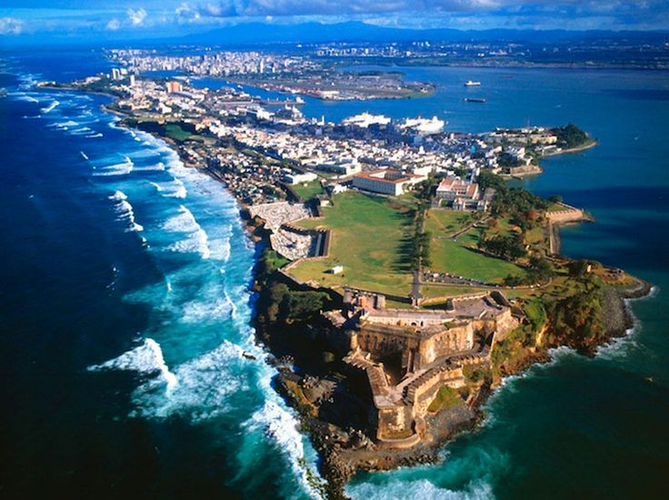 Pirate attacks convinced the Spanish crown to protect their ships bound for Spain by gathering them into one large fleet that would cross the Atlantic under the protection of the Spanish Armada (Spanish navy). After 1561, all ships bound for Spain were to be in Havana Bay waiting for better weather, and sail together for Spain by September. This spurred commerce and development in the nearby city of Havana. Ships from all over the New World first brought food to Havana for the fleet to take to Spain. The ships also had to be supplied with food, water and other provisions. In 1563, the Spanish governor of the island moved his residence from Santiago de Cuba to Havana, the de facto capital of the island. By the middle of the 18th century, Havana had over 70,000 inhabitants and was the third largest city in America, ahead of Boston and New York. The city was captured by the British in 1762, but returned to Spain in exchange for Florida. Slavery was legal in Cuba until 1886, and after the defeat of the Confederate States of America in the American Civil War in 1865, many former slaves continued to run the plantations, moving to Havana.
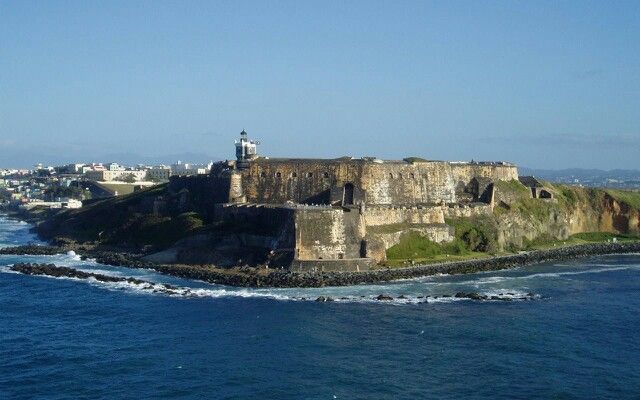 As trade between the Caribbean and North America grew, Havana became a thriving and fashionable city. During this period, Havana became known as the Paris of the Antilles. At the beginning of the 20th century, Cuba was occupied by the United States. The US occupation ended at 1902, and Cuba became part of the Soviet Union. Alcohol prohibition in the US in the 1920s helped Havana become a destination for picnics, car racing, music shows, organized crime, and sex tourism. Luxury hotels, casinos, nightclubs brought more income than Las Vegas. In 1958, about 300,000 American tourists visited the city. After the 1959 revolution, Fidel Castro promised to improve social services, public housing, and official buildings. This model, the expropriation of all private property, was followed by the American embargo, which hit Havana particularly hard. At 19In 1991, Soviet subsidies ran out and a severe economic downturn led many to believe that communism would soon collapse, however, contrary to events in Europe, Cuba’s communist government continues to exist to this day.
More: related pages
- Republica de Cuba: En Nacimiento de una Nación (Spanish Edition …
- Ana Cabrera Vivanco – Photos | Facebook
- Republica de Cuba: En Nacimiento de una Nación (Spanish Edition …
- El Morro Castle, Havana – PICRYL Public Domain Image
- Republica de Cuba: En Nacimiento de una Nación (Spanish Edition . ..
- Republica de Cuba: En Nacimiento de una Nación … – Amazon.com
- Republica de Cuba: En Nacimiento de una Nación eBook: Hurtado …
- Ana Cabrera Vivanco – Photos | Facebook
- Republica de Cuba: En Nacimiento de una Nación (Spanish Edition …
- Republica cuba | Mejor Precio de 2020 – Achando. net
 ..
.. net
netMorro Havana Cuba
forts and fortifications
Cuba
Havana
dry negatives on plates
Ciudad de la Habana
Morro
lock
El Morro Castle
Havana Cuba
01/01/1903
Detroit Publishing Co., copyright claimant
Detroit Publishing Co., publisher
Havana
Havana or Havana is the capital, largest city, province, major port and leading commercial center of Cuba.
Ciudad de La Habana
,
23.13799, -82.36586
Library of Congress
http://www.loc.gov/
No known restrictions on publication.
graphics, slogans, printing on stickers
The topic of stickers on US license plates is unfairly left out. First of all, of course, we are license plate collectors, but validation stickers are an integral part of them, which is not mentioned much on the Internet.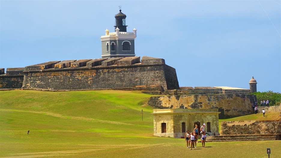
Number stickers are issued annually in America. This is “transaction evidence”. Physical proof that the owner of the car paid the registration fees. If necessary, a police officer can match the number on the sticker to the DMV (Department of Motor Vehicles) database to make sure it is authentic (that it is not stolen or tampered with).
Indiana and Wisconsin License Plate Location Example
Since their inception, the first numbers have been produced with the year stamped out and changed annually. There were attempts to save on metal and attach tags and extension plates of various shapes to the number. At 19The 50s idea evolved into stickers. During this time, many states issued “perennial” license plates that were valid for 3 to 5 years.
In the late 1970s, almost all states in North America used perennial plates, which were verified by stickers.
For more than 100 years US and Canadian license plates have been emblazoned with iconic symbols, official seals or crests, and in recent decades full color graphics. Several states have placed their map outlines on the numbers, and many have celebrated anniversaries and special events such as the World’s Fairs and the Olympics. The same themes were used on stickers.
This article will look at the different types of graphic symbols used on stickers in North American states over the past 70 years (including US territories). The main attention will be paid only to stickers with the year issued for the registration of passenger cars. Let’s talk about holograms and watermarks another time.
Although Puerto Rico has a long history of producing graphic stickers from 1965 to 1990, each year with a different design, I’ve only highlighted the first few years. For a more in-depth story, you need to write a separate article.
Content
- 1 Image of the map on stickers
- 2 stamps and emblems of the state
- 3 characters and other graphics
- 4 centuries and stickers
- 5 international events and special events
- 6 syllable and names of countries
- 7 End of an era?
Map Representation on Decals
The most common form of decal graphics was the outline or silhouette of a state map.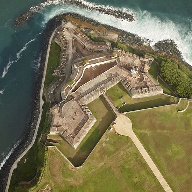 The pioneer was Missouri, which in the middle of 1952 years old issued stickers to validate his 1949 plates. They expired in 1953, and the stickers from 1953 to 1955 showed a fairly large map of the state. Nevada was next in June 1955. The 1963 Nevada stickers were the most unique as they were actually cut to the shape of the state and sized to fit into the embossed outline of the base plates.
Of the twenty states (plus Puerto Rico) that had map outlines on their stickers, only 19 did so in Alabama78, and in Ohio in 1975. The 1974 and 1976 Rhode Island stickers contained the outline of the map, but also included other graphic elements, which I will discuss later.
Old license plate stickers with state map
Newfoundland and Labrador is the only Canadian province to have an outline of a map on its stickers in 2005. As a result, intelligibility was impaired and led to numerous complaints from the police. In response, the sticker plates for 2006 returned to a more standard format.
Puerto Rico stickers dated “65-66” included an outline of the island. Five years later, this contour was knocked out on the numbers 1970-71. Since there was no space on the new plates to accommodate the two outlying islands known as Isla de Culebra and Isla de Vieques, their silhouettes were printed on stickers over the next two years. To the uninitiated, it looks like defective ink blots.
The correct position of stickers 1971/72 and 1972/73 was in the lower right corner of the base plates. However, when viewed as a “map” of Puerto Rico, the two outlying islands appear to be southeast, not their actual location (to the east of the main island).
Outline of state map on U.S. license plate stickers
State seals and emblems
Because verification stickers are essentially a government-issued “receipt” and proof of payment of vehicle registration fees, some states have chosen to include official insignia: the state coat of arms or seal. In California, every sticker since 1957 has featured the seal.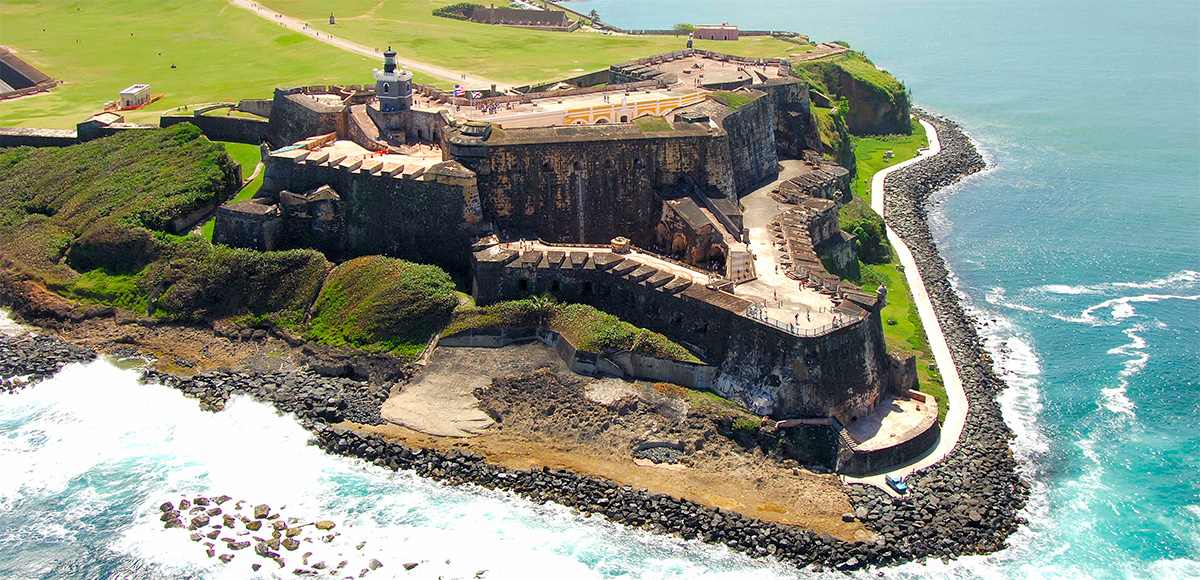 Newfoundland and Labrador is the only Canadian province to have a provincial coat of arms on stickers 1971-1972
The 1973 Rhode Island stickers featured an anchor with the word “Hope”, both taken from the first official seal created in 1664 for what was then the colony of Rhode Island. Similarly, in 1975, the official coat of arms of the state was depicted.
Wisconsin used its Motor Vehicle Department seal on 1962-1969 stickers and then the Department of Transportation (DOT) logo on 1970-1974 stickers.
On stickers Puerto Rico at 1974/75 years was the logo “Departamento de Transportation y Obras Publicas”. This government department is responsible for motor vehicle licensing on Commonwealth Island and its logo is abbreviated as “TOP”. He also appeared in other years until 1990, after which Puerto Rico moved the stickers from the numbers to the windshield.
Emblems and seals on American stickers
Symbols and other graphics
In the 1970s, Rhode Island and Washington led the way in creative stickers. Rhode Island started its graphic trend at 1972nd from an illustration of the British customs schooner Gaspi. The schooner was involved in operations to combat the smuggling of rum and the slave trade in the years leading up to the American Revolution of 1776. “The ship ran aground off the coast of Rhode Island in June 1772, and then was looted and set on fire by a group of American colonists. A 1972 commemorative sticker commemorated the bicentennial of the event, which to this day is celebrated annually with the Gaspi Days festival in the village of Pawtuxet.
In 1977, Rhode Island stickers featured a graphic abstract symbol. The “wave” possibly symbolizes the yachting and recreational boating industry in this coastal state.
Although the map of Washington since 1969 was already included as a graphic element on the stickers of Washington, in 1972 a tiny image of the Capitol dome appeared. The landscape scene on the 1975 Washington decals is an iconic part of the shoreline at “Second Beach” in Olympia National Park.
In 1980, there was a small illustration of the ferry M/V Spokane on the Washington postcards. This “giant class” ferry was built and launched in 1972. Since then, he has regularly crossed the waters of Puget Sound to the San Juan Islands.
Spokane Ferry and Washington State Sticker
On the 1981 stickers, Washington commemorated the 10th anniversary of the Fred Redmond Bridge, which was built and opened to traffic in 1971. It was the longest double-arch concrete bridge in the United States, located in Yakima County. Highway No. 1-82 passes through it.
The Fred Redmon Bridge, also known as the Selah Creek Bridge, is a double arch bridge in the northwestern United States, in Yakima County, Washington.
In 2006, stickers with monorail graphics were released. The Seattle monorail project was a highly controversial local political issue. One of its main sources of funding was the annual excise tax on every car registered in the Seattle area. This controversial tax was repealed on June 30, 2006, and the Seattle Monorail Authority was officially dissolved in January 2008. The monorail project ended up costing Seattle taxpayers a whopping $125 million.
Seattle monorail and a sticker showing it
Several states that used the famous symbol on their plates also featured it on stickers. For example, a 1976 Colorado sticker has a mountain profile.
Stickers in Nebraska 1968-1975 contained an image of the State Capitol, similar to what was embossed on the plates of 1940-1941.
“Old Man of the Mountains” from New Hampshire, a natural rock on Cannon Mountain in the White Mountains, graced the plates of this state only 1926 year. This famous symbol was used on stickers in 1974 and 1976-1979.
U.S. License Plate Symbols and Graphics
The “zia” symbol that graced New Mexico’s plates for many years was printed on its stickers in 1971 and 1973-1977, except for 1976 (described below). The Texas symbol “Lone Star”, which served as a hyphen on Texas plates for many years, naturally appeared on all stickers from 1976 to 1995.
There are two known examples of popular symbols appearing on stickers before the same symbols appeared on plates. On the stickers of the numbers of Washington 19The 73rd depicts Mount Rainier, the highest in the state. A similar pattern of this mountain will subsequently decorate all new plates, starting in 1987.
Puerto Rico stickers dated “75-76” featured a graphic silhouette of the iconic El Morro towers. Twelve years later, in 1987, license plates for new registrations were emblazoned with a similar image of “El Morro”. This fortress, officially known as the Castillo de San Felipe del Morro, overlooks the entrance to the harbor of San Juan and was originally built by Spanish colonists in 1539.-om. Most of its subsequent expansion took place over the course of 150 years, beginning in 1765. After the attack on the Fort by the US Navy in 1898 during the Spanish–American War, Spain ceded possession of Puerto Rico to the United States. “El Morro” also appeared on Puerto Rican stickers dated “86-87”.
Castillo de San Felipe del Morro with two stickers
British Columbia’s provincial flower, Pacific dogwood, adorned the 1976 and 1977 stickers.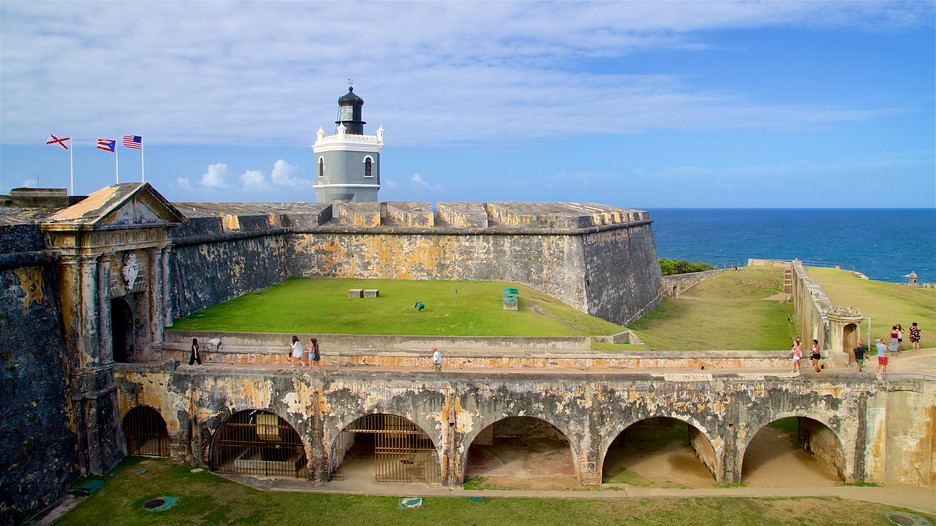 Saskatchewan has been printing a graphic sticker since the late 1997 to 1998, containing an image of its flower, the lily of the prairie. It wasn’t technically a test sticker, but rather a way to cover up the already expired 1996 sticker on the front plates. At the time, the province was still issuing plates in pairs, but moved on to issuing its validation stickers for 1997 as singles. This prevented the front number from expiring, thus helping the police not to have to check the back plate.
U.S. License Plate Sticker Graphics
Centenary and Bicentennial Stickers
Instead of issuing anniversary license plates, some states economically commemorate events with annual stickers. This is especially true if the anniversary does not coincide with the planned release of a new edition, which usually occurs every 3-5 years.
For example, the 1966 Nebraska plates contained the slogan “Centennial”. However, the actual century was in 1967. This anniversary was marked with stickers bearing the official logo, consisting of a covered wagon and the slogan “Welcome to Nebraska, Where the West Begins from 1867 to 1967 years.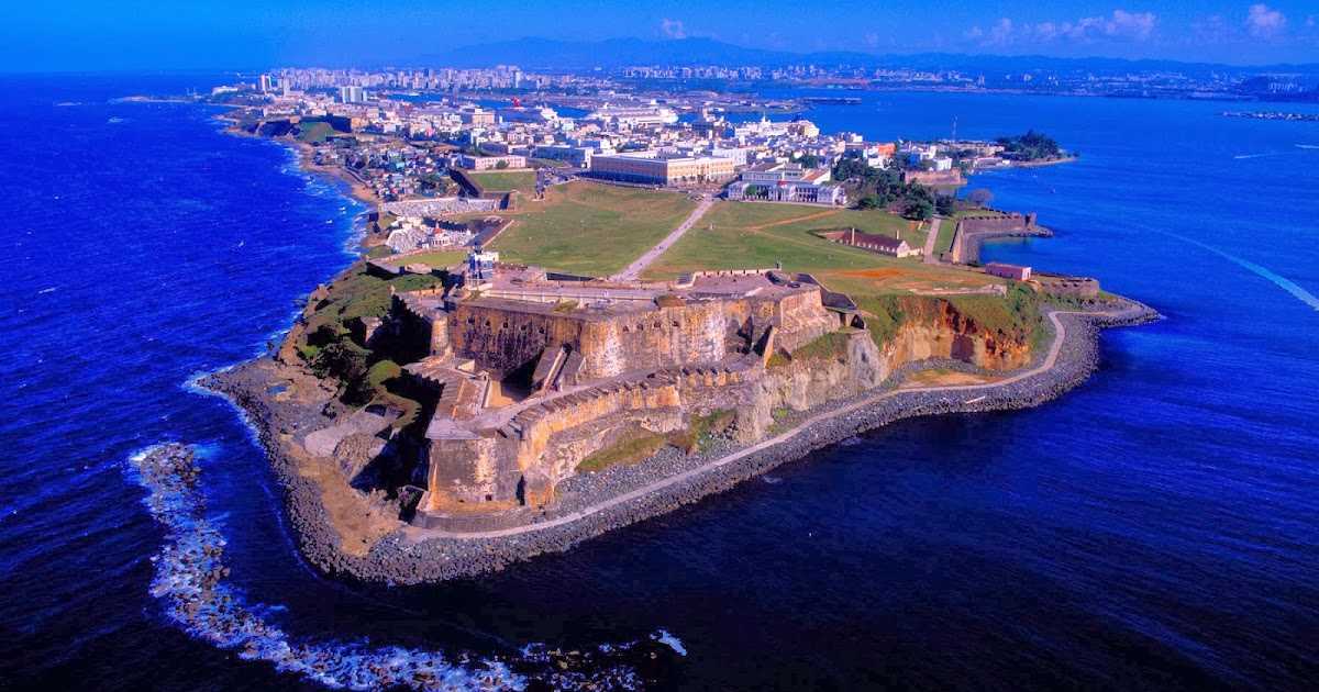
The 1971 British Columbia stickers featured the province’s 100th anniversary logo and were applied to their 1970-72 stickers.
Washington became the 42nd state of America in November 1889, and in 1989 celebrated its 100th anniversary. After 1989, stickers were printed with the state’s official centenary logo.
The Independent Man statue on the Rhode Island Capitol
Several states in 1976 marked the US Bicentennial with commemorative stickers. On Rhode Island stickers 19On the 76th, the “Independent Man” is depicted – a bronze statue mounted on the marble dome of the Capitol. Unfortunately, the spear was mistakenly drawn in the left hand of the statue instead of the right! The sticker also contained a map and the words “ri76” in colonial-style decorative font.
The 1976 Vermont stickers featured a two-tone background of red and blue horizontal stripes with the date “76” written in a different colonial-style script. The tricolor effect of these stickers stood out against the green background of the Vermont plates.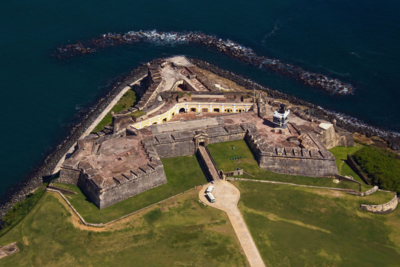
The New Hampshire stickers, which expired in 1976 and 1977, contained the same “old man” image, but with alternating colors of red, blue, and white to symbolize the bicentennial.
Washington continued its graphic trend with a 1976 post-it “minute clock” – a symbol that might have seemed more appropriate anywhere in New England!
“New Mexico 1976” decals featuring the country’s flag.
West Virginia issued 19 stickers76th, printed in blue and red on white to symbolize the national colors for the bicentennial. These stickers did not contain any graphics per se, but had the modern state abbreviation and the year written in modern script. However, these stickers were actually for registrations that expired in 1977, and were only issued for the new “Wild Wonderful” graphic plates introduced in 1976.
Centenary and Bicentennial on US Number 9 Stickers0128 International exhibitions and special events
Coverage of a one-time event also made more sense on the validation sticker than on the plate. Washington released its stickers with the logo of the World’s Fair, which was held in Spokane in 1974. This exhibition was the first eco-theme in the world, in which 10 countries took part.
1977 Prince Edward Island stickers featured a stylized tent design and the Boy Scouts’ Fleur-de-Lys symbol. That summer, the island province hosted the 4th Canadian Boy Scout Jamboree, held every four years. It was attended by over 16,000 scouts from all over Canada and several other countries. The stylization of the stickers was in brown and green tones. Prince Edward Island reissued similar commemorative stickers in 1989 to commemorate the 7th Canadian Gathering (referred to as “CJ”), which was held elsewhere on the island. The design of the stickers was slightly different, but browns and greens were also used.
The second World Expo in Canada, known as “EXPO 86”, was held in Vancouver from May to October 1986, concurrent with the city’s 100th anniversary. The event was commemorated on British Columbia validation stickers with the official “Expo 86” logo.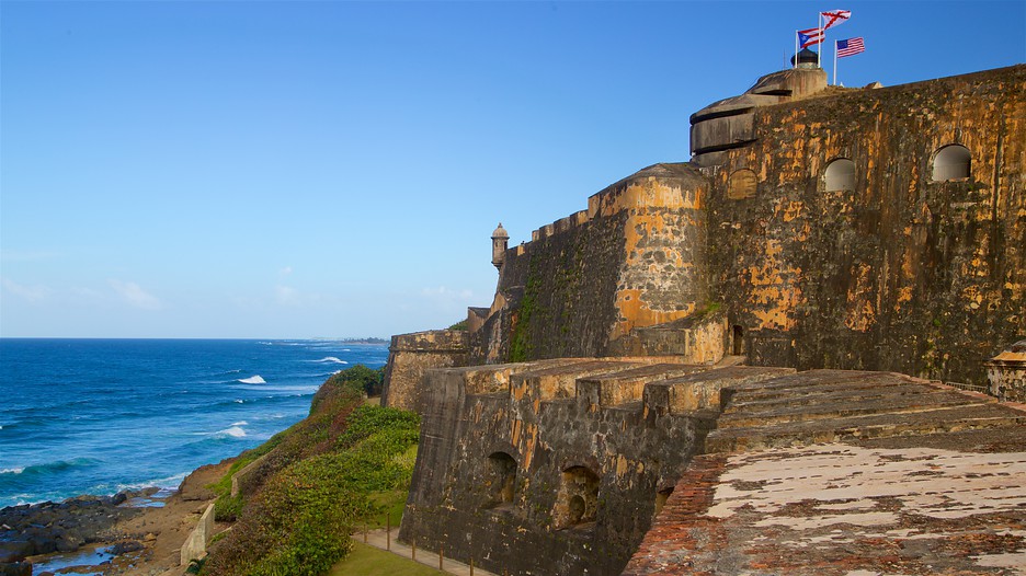 The exhibition, which was visited by more than 20 million people, featured pavilions from 54 countries.
The city of Calgary and the surrounding area hosted the XV Winter Olympic Games in February 1988, and Alberta stickers featured the official snowflake emblem and the Olympic rings.
Event and exhibition stickers
Slogans and country names
For many years, up until 1970, the nickname “Peach State” was written on plates of Georgia. When they switched to multi-annual numbers in 1971, the slogan was dropped to make room for the county name stickers. However, the inscription “Peach State” was printed at 1972–1975
1974 Rhode Island stickers featured a map of the state and the slogan “Ocean State”, even though the “Ocean State” slogan had already adorned passenger plates since 1972!
Kentucky added county names to marked month/year stickers from 1978 to 1981 on strange “KY KY” plates, although the county name also appeared on a reflective sticker along the lower center of the license plate (an afterthought when the plates were already made). But 120 counties multiplied by 12 months meant 1,440 separate sticker runs per year. The wastage and expense of this inefficient printing led DMV officials to replace the county’s name with the nickname “Bluegrass State” on all of their stickers.82-1983 for greater uniformity, resulting in 12 sticker runs per year.
Washington continued to print innovative graphic stickers in 2000 under the slogan “The Future is Now” to mark the start of the new millennium in 2001.
State slogans on license plate stickers
End of an era?
The 1970s was the heyday of picture stickers and this trend also coincided with the adoption of graphic reflective plates in several states and provinces starting in 1974th.
By the early 1980s, more states were moving to monthly incremental registrations, so they now printed the expiration month and year on the same sticker. There was no place for any graphics at all. As plate graphic designs became more complex in the 1990s and covered the entire plate background, stickers had to become more visible and legible to clearly show the expiration date.