Cueva del viento en isabela: Cueva del Viento | Discover Puerto Rico
Bosque Guajataca & Cueva del Viento, Isabela
Bosque Estatal de Guajataca localizado al noroeste de Puerto Rico en el pueblo de Isabela. Puedes llegar por la carr. 446 o Carr. 111
Según la página del Departamento de Recursos Naturales y Ambientales de Puerto Rico este bosque comprende unas 2,357 cuerdas y está clasificado como bosque húmedo subtropical. Se destaca por los mogotes, las cuevas, los sumideros y las vistas de un paisaje espectacular. Tiene el mejor sistema de veredas de todos los bosques estatales. Su periodo de sequía es entre enero a marzo y su temperatura más alta se registra en el mes de julio y agosto.
Nosotros optamos por la carr. 446 ya en Isabela utilizando la aplicación de Maps por medio de un celular muy efectiva por cierto. Siempre colaborando los letreros de la carr. 446 hasta encontrar el del Bosque Guajataca. Aquí puedes ver la carretera por la cual transitamos tienes que ser bien cauteloso y tomas las medidas que se sugieren en el letrero amarillo que también puedes ver en la imagen.
Entrada: Libre de costo.
Estacionamiento: Libre de costo.
Sugerencia: Ropa lo más cómoda posible, zapatos cerrados, linterna si es que va a entrar a una de las tres cuevas y agua. La caminata hasta la cueva del viento es de hora y media aproximadamente. Yo fui hace una semana exactamente (marzo) y hacía bastante.
Deténgase en la oficina para firmar el registro de visita y para que le entreguen el mapa del bosque el cual no viene nada mal. Lleve todo lo que sea necesario ya que allí no hay donde comprar nada si necesita utilizar las facilidades sanitarias les comparto que están en buenas condiciones. Es recomendable que solo visite la Cueva del Viento ya que es la única de las tres cuevas con fácil acceso. En la oficina pregunté cómo podía visitar las otras dos cuevas (Cueva Los Pérez y Cueva Efraín López) en una próxima ocasión me dijeron que podía coordinar una visita guiada por el biólogo del bosque con un mínimo de 10 personas. Este bosque también cuenta con área recreativa y para acampar.
Saliendo de la oficina a su mano izquierda es la ruta para la cueva y el observatorio. Siento que la persona que me atendió allí debía ser más cordial e instruirme mejor. Cuando empezamos la caminata nos encontramos con una pequeña parada que podías caminar hacia el lado izquierdo (lado que te dirige a la Cueva del Viento) o caminar hacia el lado derecho hacia el Observatorio. Que creen que hicimos? Primer error, nos fuimos por el lado derecho porque no vimos ningún letrero que señalara hacia la cueva pensando que quedaría de camino por el Observatorio. Después de caminar como 20 minutos y subiendo mis amigos dijeron “creo que vamos mal”. Estábamos subiendo y cada vez el camino más pequeño. El señor de la oficina nos dijo que perderíamos la señal de los celulares pero que podíamos apuntar el número de la oficina por alguna emergencia o pregunta. Milagrosamente yo tenía un poco de señal. Llame y nada! Gracias a Dios no era una emergencia vida o muerte. Viramos hasta la parado y tomamos el otro camino. Mi consejo es siempre que se encuentren una “Y” camino a la cueva opten por el lado izquierdo aunque más adelante no vean letreros en la “Y” que mencionen la cueva.
Por más de una hora caminando no nos encontramos a nadie empezando a dudar si realmente íbamos bien. A veces escuchábamos gritos y dejábamos de hablar para ver si entendíamos algo. Nada, seguimos caminando en una yo grite a quien podía estar cerca/lejos de nosotros y preguntarle si íbamos bien. Según él sí, más adelante nos lo encontramos y nos desvío un poco. Nuevamente mis amigos dijeron este no puede ser el camino. Nos encontramos a otro jóven que estaba buscando al que nos había dado la dirección a seguir. El sí sabía por dónde era y nos confirmó que era por donde íbamos. Ya estábamos cerca solo nos faltaba unos 10 minutos más.
Este es el letrero que te encuentras ya en el tope de la cueva.
Según en la oficina el tiempo que te puede tomar para recorrer la cueva es 1 hora aproximadamente. Bajamos por la vereda hasta llegar a la entrada según se muestra en las imágenes. Dentro de la cueva solo encontramos murciélagos.
Estas imágenes son solo del Bosque Guajataca y la Cueva del Viento. La experiencia vale la pena y no conlleva mucho gasto. Protege y conserve estos recursos naturales.
-Brenda Sorrentini
Like this:
Like Loading…
Filed under Uncategorized and tagged bosque, Caribbean, cueva, Fotografía, Isabela, Lugares, Naturaleza, Opinion, Puerto Rico, Travel and Tourism | 6 Comments
Cueva del Viento – Tourist attraction in Arecibo, Puerto Rico
Frequently mentioned in reviews: place (6) entrance (6) minutes (6) hiking (7) area (7) park (8) caves (8) closed (8) Bring (9) good (10) stairs (11) hike (16) trail (19) cave (47)
5Alex G.
10 months ago
This is unusual and very interesting experience: exploring cave on your own without the guide. Nice hiking trail leading to the cave is a big bonus too. Awesome!
5Dmitri R.
3 years ago
Explore in your own
5Carlos D.
3 years ago
Amazing and relaxing!!!!!!!!!!!!!!!!!
5Douglas P.
3 years ago
Awesome experience for anyone. You should try it.
5Noel A. Rivera M.
3 years ago
(Translated by Google) Very pretty!!!
(Original)
Muy bonito!!!
5Da R.
3 years ago
The trail still needs to be cleaned up, but if you are willing to hike through fallen trees, you will get to the cave. Several parking areas around this forrest so make sure you remember where you park and which trail you started on.
Limited signs but there are enough to get to the cave. There are a couple observation towers as well. One is located off a trail. The other is located directly off of carretera 466. Both offer great views.
Bring flashlights, headlamps, and replacement batteries. Better safe than sorry when going to places like this.
There are whip spiders, land crabs, and bats inside the cave.
5Jordan W.
5 years ago
Wonderful
5Josue N.
5 years ago
(Translated by Google) A great place for hiking and having a good day in the Bosque de Guajataca.
(Original)
Un gran lugar para hacer senderismo y pasar un buen día en el Bosque de Guajataca.
5Gian T.
5 months ago
I’ll give 5 ⭐️ in this review since this is a natural area, you cannot make it better. We can only control the access, and the DNER is doing a good job maintaining it (see my Bosque de Guajataca review).
Of course be careful when going down from the main trail to the cave entrance and then using the wooden stairs. My flashlight failed, so we had to go in using our cell phones flashlight. It’s a shame that over the years ppl have obviously damaged the natural structures, stalagmites and stalactites, but the big ones and the ones on the roof are still there. This cave is found in the karst region, so it’s made of limestone. You will feel water falling from the top as it percolates from the surface. Unfortunately we did not see any bats or whipspiders (guabá).
Considering it’s found in a public area with not direct access control, is in really good shape. Worth the trek.
*Pictures from inside the cave are awful, but they give an idea of what to expect.
5Elsie E. V.
3 years ago
Great!!!
5Wanda L.
10 months ago
Enter at your own risk.
Stairs are damaged so be extra careful other than that
Enjoy the trip!
Cool bat sightings and crystals and much more! It’s a whole new world down there!
5Caroline M.
8 months ago
This cave is awesome! Must see if you’re the adventurous kind and likes to be outside. Bring a flashlight, seriously! Bring sneakers or nonslip shoes because inside the cave it is slick.
5Tara H.
 7 months ago
The first set of caves were closed, but the second smaller cave was so cool!
The hike is about 45 minutes each way. It wasn’t too strenuous, just a few narrow parts and was a bit slippery because of the rain the night before.
Definitely come from the north entrance, the south entrance was narrow and rocky due to landslides.
The park ranger was so helpful, we really appreciated him and the fact he came out to our car when we looked confused. He highlighted a map for us and gave great instructions.
5Mark H.
1 year ago
Beautiful area and amazing experience. Trail is well maintained up until the stairs. Be safe and smart. Caves have there own set of dangers but very rewarding when enjoyed safely.
Parking was limited but available and immediately outside the trailhead. There is a network of trails to follow and the path to the cave is well-marked.
5O.
3 months ago
Wonderful and interesting cave to visit. Each way is around 45 minutes hiking in a normal pace. Easy trail to walk. Always follow route #1. Bring a flashlight, it is needed once inside the cave. Stairs into the cave are not in the best conditions, but with caution is possible to enter.
5Guanica R.
3 months ago
Free parking, free park great for exercise and safe, now very beautiful but very remote, no cell phone service. Stairs to go down to the cave are in bad shape. Take your time and go one by one. Enter at your own risk. Tell someone before you go. There are two caves in the area viento and if you pass that one there is the other cave. It will take 3 hours approximately. Beautiful area. But is still a great hike.
5Alex L.
6 months ago
March 6th 2022. Highly recommend visiting. Was a little tricky finding which way to go as directions to the cave are not clear on the trial but use a good gps trail app on your phone and you should be good. (I used the AllTrials app and typed in “The cave of the wind Via Trail 1”.) I do have the yearly subscription as it’s VERY useful for hiking and finding trails even in Puerto Rico! The AllTrails app will also help you to know where to park, but if I’m not mistaken it’s Km 11.4 on 446 (park ranger office)
As far as getting down into the cave. The stairs are not in the best shape but I had no problem getting down and back up. Bring the brightest light you got. Your phone light will not cut it well
5David D.
2 years ago
😉
5Darryl G.
3 years ago
Self guided hike thru the hilly forest to a large cave. What’s not to like? Single lane winding road to the park entrance. Not for the nervous driver.
5Clayton L.
2 years ago
Nice hike, has some slippery spots. Bring some good shoes and clothes you don’t mind getting muddy. You can get by with your cell phone camera, but I recommend real flashlights / lanterns.
5Jennifer A.
3 years ago
Nice hike and really cool caves to explore
5Viktor R.
2 years ago
Sizeable cave, hardly anyone on a Sunday afternoon. Easy hike (about 45 mins) from car park. Two sets of rickety and slippery stairs, take special care on descent.
Down in the cave ground is fairly level, easy going, just a bit slippery where muddy. Be sure to bring headlamps or torches! Lovely stalagmites and stalactites, please take care not to break anything.
5KYLE D.
2 years ago
Incredible cave – and a beautiful trail through the jungle to get there.
1. The trail head is located right next to the Ranger station at 11 KM on PR 446. (Not 9 KM like some websites suggest). There are other trails but they don’t seem very well maintained.
2. Bring good flashlights. Phone flashlight won’t cut it.
3. There was fencing blocking the staircase as of February 2020 when we went, i. e. it has been closed. We were able to climb over the fencing with little issue though and the cave was still accessible.
4. The trail getting down was not easy but not impossible. A few steps on the wooden staircase were busted and the trail down was washed out. There is hand railings so it’s still pretty safe but it’s definitely a moderately strenuous hike to reach the cave mouth. The hike along Trail #1 to the staircase was pretty easy though.
If you are looking for caves in PR and unable to go to Cueva del Camuy – this is an excellent alternative.
edit:
I would recommend mapping to Torre Observación #1 Bosque Guajataca while driving south along PR 446 (from Route 2) because the trailhead is about a quarter mile before the observation tower – so if you pass the observation tower while driving south along PR 446 – then you have driven too far.
5Miguel S.
3 years ago
(Translated by Google) Excellent to go with the family.
(Original)
Excelente para ir con la familia.
5Toon R.
3 years ago
(Translated by Google) There are no words or pictures that can describe the natural beauty!
(Original)
No hay palabras ni fotos que pueden describir la belle a natural!!
5Alexis R.
3 years ago
(Translated by Google) There are snakes 🐍
(Original)
Hay serpientes 🐍
5Edgardo N.
3 years ago
(Translated by Google) Place that all Puerto Ricans and tourists should visit for hiking. Spectacular experience. Congratulations to the administration that with little they do much.
(Original)
Lugar que todo puertorriqueño y turistas deben visitar para practicar senderismo. Espectacular la experiencia. Felicitaciones a la administración q con poco hacen mucho.
4Heriberto G.
4 years ago
(Translated by Google) Spectacular journey through the forest
(Original)
Espectacular recorrido por el bosque
4Jamie J.
 2 years ago
Excellent hike! Cave is awesome
4M.
2 years ago
Route 25 (at km10) takes 1hrs 15 min. it does not pass by the cave. When you start walking it. You can choose quite soon if you want to head to trail #26 or #6. Maybe one of them leads to the cave Cueva del Viento.
4Hendrik W.
2 years ago
We went to the Bosque de Guajataca today for a hike, with the intention to visit the Cueva del Viento. We arrived and the ranger at the station was very friendly, helpful and gave us a map. First thing we learned is that the cave was closed. We were surprised to find that there are many paths for hiking in the bosque and we took #1 towards the cave. Nice and relatively easy hike. Indeed found that stairs down to cave were blocked. We continued for a while thinking that the might return a different way using other paths. However most paths were closed and we ended up returning the same way.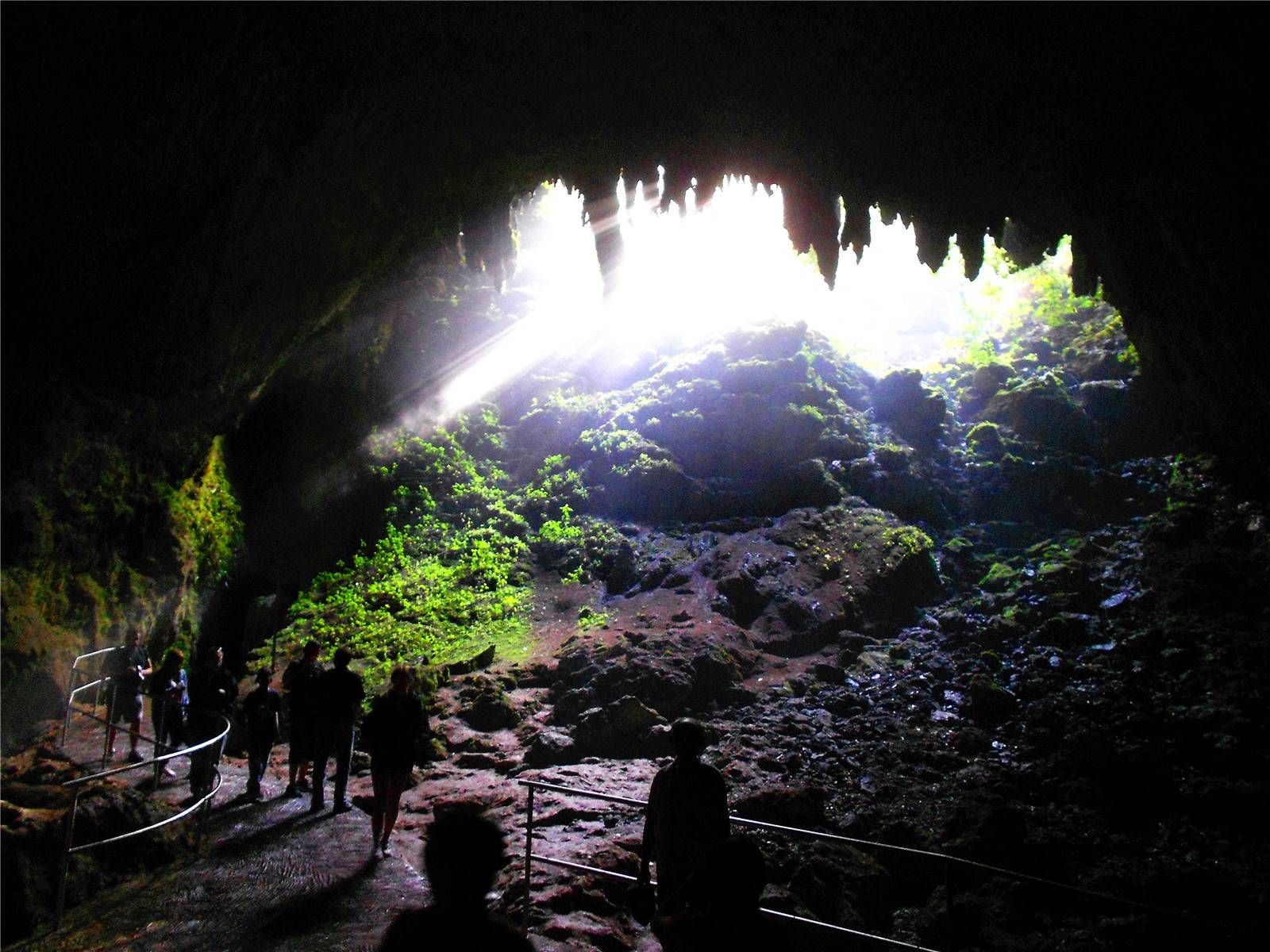 Interesting hike after all.
4Chris D.
1 year ago
About a mile and a half hike, keep driving till you get to three main office area (easier to access from the 2). Signage could be better, but stay on the main trail and you’ll get there eventually. The stairs were the most dangerous part of the hike and were VERY slippery! Once in the cave we followed it to the right and somehow went in a circle that brought us right back to the entrance. Bring an umbrella or a rain coat!
4Amador P.
3 years ago
I really love this place
4Brenda Liz S.
3 years ago
If near the area, this is a place you must visit. Beautiful cave!
4Scott M.
2 years ago
This place wasn’t easy to find not a lot of signage. The trial head is just across from parking lot see my pics there are a few buildings near by. Have google direct you to this parking lot otherwise it might select the middle of the jungle and this will take you way out of your way. The trail was beautiful follows the ridge of the valley has rocks and stumps and could be muddy if raining. Proper footwear is a must.
There were a couple down trees across trail. Pretty much flat does not have a lot of gain or drop in elevation just a little at the beginning and near cave entrance. Stairs at the cave were ok some steps felt a little weak. There are two rooms in the cave one on your right and one on the left not very deep short distances to the end of both. Also headlamps are needed for in the caves. We saw bats and tailless whip scorpion. Lots of Mushrooms and fungus. Happy trails.
3Beth L.
3 years ago
Good for an adventure, not a walk in the park. We are a family of 4 – 2 adults, 2- 15 yr olds. The paths are well marked and in many parts maintained. However, once you go on the specific trail to the cave, it is closed, but we continued anyway. The trail is littered with maybe 25-30 clusters of fallen trees that block the trail. The staircase that leads to the mouth of the cave was blocked and in many parts broken. We finally arrived at the cave. Rather small, some pretty natural structures. Easy to navigate if you bring a headlamp. No guide is required. We saw a couple colonies of bats, a cave crab! and of course stalactites & stalagmites. Not sure that I would say it was worth the effort – oh did I mention? It was raining.
3Alien in your W.
4 years ago
(Translated by Google) I went today, August 19, 2018, and after walking 30 minutes it was closed due to a collapse of trees that are on the road. The route in the forest is cool, but sadly we could not reach the destination that was the cave of the wind.
(Original)
Fui hoy, 19 de agosto de 2018, y despues de haber caminado 30 minutos estaba cerrado por un derrumbe de arboles que hay en el camino. El recorrido en el bosque esta chevere, pero tristemente no pudimos llegar al destino que era la cueva del viento.
3Jill F.
 8 months ago
March 1st, 2020 the first set of caves are closed. It’s a good hike, roughly 90 minutes, through the forest to get to the set of stairs leading down to the caves. The stairs are a no go – no go. You can keep walking the trail to get to a second cave, it’s nice, but very small and not worth the extra 30 minutes down a steep grade. My advice: If you love hiking through the woods, go for it. Bring lots of water and snacks and wear really good shoes! We had a good time, it was an adventure for sure, but dang! No caves! Bad luck.
3Jean-Sébastien G.
4 years ago
The cave as of September 2018 is far from being easily accessible. The path is closed but we venture there anyway. You will have to jump over and crouch under about 50 trees that have fallen on the path. Sometimes the path bifurcates because there are too many trunks in the way. It seems like people have done it before, you will not get lost.
The final descent by stairs is covered by a giant tree. We went around the stairs to go down, but I don’t recommend that. We went up the stairs when we came back.
It seems that the closure is quite permanent, I don’t see much work being done.
From the Danger sign, it will take you about 45 minutes to reach the cave.
No doubt, it is scary, as you don’t know if anything is safe. Quite the adventure. The cave is pretty, and… nobody was there 😅. Our ages, 26, 32.
1Alexandra A.
3 years ago
As of today, January 4th 2019, there was neither path nor signs for this place, we were sad that after a long rough drive we did not get to see the cave. We asked some locals about the cave and they had no idea (never heard of the place) where it is.
Alcohol shares
-16%
Wine Il Caberlot Toscana IGT Il Caberlot 2015 750 ml
Code:
22691
Manufacturer:
Podere Il Carnasciale
Volume:
0. 75 l
75 l
Strength:
13.5%
Country:
Italy , Tuscany IGT (Italy)
Color and sugar content:
red,
dry
Grape variety:
Caberlo
Out of stock
$27,325
Report Admission
-16%
Wine Il Caberlot Toscana IGT wooden box Il Caberlot in a wooden box 2013 3000 ml
Code:
22689
Manufacturer:
Podere Il Carnasciale / Podere il Carnasciale
Volume:
3 l
Strength:
13.5%
Country:
Italy , Tuscany IGT (Italy)
Color and sugar content:
red,
dry
Grape variety:
Caberlo
Out of stock
122 644
Report Admission
-16%
Wine Carnasciale Carnachale Tuscany 2017 750 ml
Remaining stock:
few
Code:
560001
Manufacturer:
Podere Il Carnasciale / Podere il Carnasciale
Volume:
0. 75 l
75 l
Strength:
14%
Country:
Italy , Tuscany IGT (Italy)
Color and sugar content:
red,
dry
Grape variety:
Caberlo
13 640 o
11 458 p
Add to cart
or
In 1 click
-16%
Wine Il Caberlot Toscana IGT Il Caberlot 2018 1500 ml
Remaining stock:
a lot of
Code:
22690
Manufacturer:
Podere Il Carnasciale
Volume:
1.5 l
Strength:
13.5%
Country:
Italy , Tuscany IGT (Italy)
Color and sugar content:
red,
dry
Grape variety:
Caberlo
64 990 o
54 592 p
Add to cart
or
In 1 click
-16%
Wine Carnasciale Carnachale Tuscany 2018 750 ml
Remaining stock:
few
Item no. :
:
562128
Manufacturer:
Podere Il Carnasciale
Volume:
0.75 l
Strength:
14%
Country:
Italy , Tuscany IGT (Italy)
Color and sugar content:
red,
dry
Grape variety:
Caberlo
11 490 o
9652 p
Add to cart
or
In 1 click
-16%
Wine Il Caberlot Toscana IGT Il Caberlot 2017 750 ml
Code:
27505
Manufacturer:
Podere Il Carnasciale
Volume:
0.75 l
Strength:
13.5%
Country:
Italy , Tuscany IGT (Italy)
Color and sugar content:
red,
dry
Grape variety:
Caberlo
Out of stock
$28,972
Report Admission
-16%
Wine Il Caberlot Toscana IGT Il Caberlot 2014 1500 ml
Code:
586033
Manufacturer:
Podere Il Carnasciale / Podere il Carnasciale
Volume:
1. 5 l
5 l
Strength:
13.5%
Country:
Italy , Tuscany IGT (Italy)
Color and sugar content:
red,
dry
Grape variety:
Caberlo
Out of stock
$54,592
Report Admission
-16%
Wine Il Caberlot Toscana IGT Il Caberlot 2016 1500 ml
Remaining stock:
few
Code:
591088
Manufacturer:
Podere Il Carnasciale / Podere il Carnasciale
Volume:
1.5 l
Strength:
13.5%
Country:
Italy , Tuscany IGT (Italy)
Color and sugar content:
red,
dry
Grape variety:
Caberlo
71 050 o
59 682 p
Add to cart
or
In 1 click
Thiers – Barcelona, distance (km, miles), route on the map, time difference
Tiers – Barcelona, distance (km, miles), route on the map, time difference
Airplane start
Car start
Distance
City
Thiers-Barcelona Distance
km
miles
Distance by car
226 km
9140 miles Straight-line distance
3
driving time
Show route
Other distances
Tiers – Fresno del Rio Tiers – Villanueva de la Serena Tiers – Caballar Tiers – Orbita Tiers – Val do Dubra Tiers – Sahagun Tiers – Cuevas Bajas Tiers – Casas de Fernando Alonso Tiers – Verdú Tiers – Villagno Tiers – Albolodui Tiers – Guaro Tiers – Navas de Oro Tiers – Irun Tiers – Cervera Tiers – Trigueros del Valle Tiers – La Pobla de Farnals Tiers – Mont Blanc Tiers – Alburquerque Tiers – Vilobí d’Onyar
Return distance
See how the reverse distance goes.
Barcelona – Thiers
Content
- Distance
- Route on the map
- Airplane distance
- Flight time
- Direction of travel
- Time difference
- Interesting facts
- Travel cost
Driving distance
Distance between Tiers, Aragon, Spain and Barcelona, Catalonia, Spain on a car is – km, or miles. It will take a minute or an hour to cover this distance by car. The road is marked with a blue line on the map. By moving the markers, you can lay a new route through the points you need.
The whole route
Distance by plane
If you decide to travel to Thiers Barcelona by plane, then you have to fly a distance of 226 km or 140 miles. It is marked on the map with a gray line (between two points in a straight line).
Flight time
Approximate flight time to Thiers Barcelona by plane at a cruising speed of 750 km/h is 18 minutes.
Direction of traffic
Spain, Thiers – right-hand traffic. Spain, Barcelona – right-hand traffic.
Time difference
Tiers and Barcelona are in the same time zone. There is no time difference between them (UTC +2 Europe/Madrid).
Interesting Facts
Information about alternative ways to get to your destination.
bike
car
aircraft
The length of this distance is approximately 0.6% of the total length of the equator.
The percentage of the population is clearly shown in the graph:
Thiers – 314 (down 1,621,223), Barcelona – 1,621,537 inhabitants.
Cost of the trip
Calculate the cost of the trip yourself using the fuel consumption calculator by changing the data in the table.
km
miles
Distance:
Fuel consumption per 100 km:
Tank volume:
Fuel cost, $:
Round trip
Distance:
Fuel consumption per 100 miles:
Fuel cost2 $:
Round trip
2022
2Markers
Privacy Policy
Terms of Use
Contacts
Distance map
Loading time 0. 0105 s.
Choose a country
Australia
Austria
Azerbaijan
Aland Islands
Albania
Algeria
American Sam
Angola
Antartida
Anti -Gyua and Barbuda 9000 Anti -Gyua 9000 Anti -Garm
Armenia
Aruba
Afghanistan
Bahamas
Bangladesh
Barbados
Greenland
Greece
Georgia
Guam
Denmark
Democratic Republic of Congo
Jersey
Dominici
Dominican Republic
Egypt
Zacrea Zakla Warm Warlet Warmire
Israel
India
Indonesia
Jordan
Iraq
Iran
Ireland
Iceland
Spain
Italy
Yemen
Cabo-Verde
Kazakhstan
Kaymanov island
Cambodia
Cameroon
Catar
9000 9000 9000 9000 9000 9000 9000 9000 9000 9000 9000 9000 9000 9000 9000) Cocos Islands
Colombia
Comoros
Congo
Democratic People’s Republic of Korea
Costa Rica
cat-d’Ivoir
Cuba
Kuwait
Kyrgyzstan
Laos
Latvia
Lesoto
Liberia
Lebanium
LIVITY
LITTAS
LICHEVTEN
LUKSMBUSTRY MAVSMBUSTRY
LUKSMBUST
Madagascar
Mayotte
Macau
Macedonia
Malawi
Malaysia
Mali
Maldives
Norfolk
United Arab Emirates
Oman
Island Maine
Island of St.