El yunque peak: El Yunque National Forest – El Yunque Trail
Climbing, Hiking & Mountaineering : SummitPost
Page Type: | Mountain/Rock |
|---|---|
Lat/Lon: | 18.32000°N / 65.78°W |
County: | Luquillo |
Activities: | Hiking |
Season: | Spring, Summer, Fall, Winter |
Elevation: | 3496 ft / 1066 m |
Sign the Climber’s Log! |
Overview
El Yunque Peak is located in Sierra de Luquillo mountain range, about a half hour drive east of San Juan, the capital of Puerto Rico. The area is administered by the United States Forest Service as Caribbean National Forest. It is the only tropical rain forest preserve in the US National Forest system, and is also one of the oldest forest preserves in the Western Hemisphere, having been originally set aside by the King of Spain in 1876. Parts of the forest receives nearly 200 inches of rain a year. Because of the area’s long conservation history, it is the source of much scientific knowledge about tropical rain forests. In 1976 it was designated by United Nation’s Man and Biosphere program as a Biosphere Preserve.
On clear days, the summit of El Yunque Peak is known to have great views over San Juan metropolitan area, the northeast coasts of the Island of Puerto Rico, and Vieques Island to the east. However, dense clouds often shroud the higher parts of the range, making the upper mountain area a cool refuge from the tropical heat below. There is a summit observatory built by Civilian Conservation Corps in the 1930’s in the style of a Spanish castle, complete with a fireplace inside.
At the entrance to the National Forest on Highway 191 is the El Portal Visitor Center, a spectacular facility with much interpretative exhibits about rain forest ecology and conservation topics. Great views of the Atlantic coastline can be had from its decks.
Getting There
El Yunque Trail is the direct route from Highway 191 to the summit. Its elevation gain is 1400 feet, over 2.6 miles. There are two trailheads about 300 meters apart on the west side of Highway 191. The main one is across the road from Palo Colorado Visitor Center, the other one is a little further up near Bano de Oro (old swimming pool built with boulders).
Carry a map with you as there are a few branch trails. The lower portion of the trail has old concrete pavement built in the 1930’s. They help a lot because the soil is extremely wet and muddy most of the time. The middle and upper portions of the trail are quite rocky. There are several very well-built rain shelters along the way, providing cover as well as dry, hard floors.
Red Tape
None.
Camping
No overnight camping in the wilderness areas. There are some campgrounds in the National Forest. Camping reservations can be made at the El Portal Visitor Center, on Highway 191 at the entrance to the National Forest.
Gear
Wear sturdy hiking shoes and carry a poncho.
External Links
http://www.fs.fed.us/r8/caribbean/ – Caribbean National Forest official site.
Images
View El Yunque Image Gallery – 17 Images
Table of Contents
- Overview
- Getting There
- Red Tape
- Camping
- Gear
- External Links
- Images
How to Spend a Day at El Yunque National Forest in Puerto Rico
El Yunque National Forest adds a beautiful day of adventure to your Puerto Rico vacation. It’s a must-see!
In this guide, you’ll find information about the layout of El Yunque, what waterfalls and hiking trails are musts, the panoramic views you DON’t WANT TO MISS, and your best options for getting to and from the park.
Are you ready to spend a day at El Yunque National Forest in Puerto Rico?
Save this guide for later. Pin it!
How to Spend a Day at El Yunque National Forest in Puerto Rico
El Yunque experienced significant damage from Hurricane Maria back in 2017. What’s amazing to see is how resilient nature is! Throughout the park, you can see how the landscape has been healing itself ever since.
In addition to using this guide to plan your day at El Yunque National Forest, I’d advise also checking USDA/El Yunque National Forest for any updates or alerts before your visit to the El Yunque rainforest. You can also check in with the rangers once you arrive.
I had an amazing day hiking in El Yunque following the ranger’s advice and the most up-to-date map available.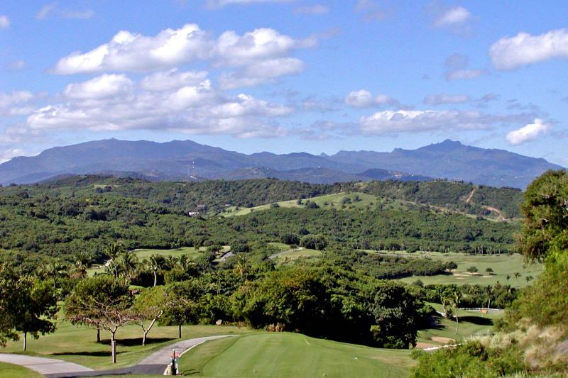
What is El Yunque Rainforest?
Located in northeastern Puerto Rico, El Yunque is the largest Puerto Rico rainforest, as well as the only rainforest in the United States National Forest system.
It was formerly known as the Caribbean National Forest until its name was changed to El Yunque, after one of the island’s Native spirits, in 2007.
El Yunque Facts
At 28,000 acres, El Yunque National Forest is relatively small for a National Forest but it’s a lush and diverse natural space that immerses you into the rainforest ecosystem.
El Yunque is home to thousands of native plants and trees, with nearly two dozen tree species exclusively found in this forest.
There are no large animals in El Yunque but it’s home to hundreds of smaller ones like birds, bats, and lizards. Of all the El Yunque animals, several can only be found here, including the Puerto Rican Parrot and the tiny tree frogs called coquis.
No matter what time of year you’re visiting El Yunque National Forest, expect the climate to be fairly consistent all year round. In the summer, the average high temperature is 80° F with a low of 68°. In the winter, the average high temp is 72° with a low of 58°.
El Yunque gets over 200 inches of rain a year. With all that rain, you’d expect to have a mosquito issue but I did not encounter one after a full day of hiking. Be prepared, though, for wet trails.
Along with a day on Culebra, hiking and swimming in El Yunque is one of the most popular Puerto Rico day trips.
El Yunque Visitor Center
In the park, you might also find a map of El Yunque national forest but a paper map from the ranger is best.
First, it’s important to know, the El Portal Rain Forest Center is CLOSED.
This was the main El Yunque Visitor’s Center before Hurricanes Irma and Maria did significant damage and shut this facility down. Extensive work is in progress to repair and reopen this visitor’s center.
Up until 2020, the visitor center had been in a short-term place just outside of the National Forest called Portalito HUB in a little town called Palmer. It’s at the base of El Yunque.
It had been a place where you could get a map, some souvenirs, bottles of water, a poncho, and use the bathroom. The employees also helped with any questions and could update you on the latest El Yunque information.
However, as of 2021, the National Forest Service is managing crowd control at El Yunque with timed reservation tickets. Find out more about how to get your ticket at recreation.gov.
Driving straight into the park, you won’t find a visitor’s center. Instead, you’re likely to see Park Staff directing you to a pull-off so you can check in with your timed-entry ticket and handing out a current El Yunque National Forest map.
It’s also an opportunity to ask any questions about trails that are open and closed on the date of your visit.
El Yunque Tours
Trails can be narrow. Small groups are best.
Guided tours of El Yunque rainforest are available. These tours typically offer hotel pick-ups and returns from San Juan area hotels. If you haven’t rented a car for your Puerto Rico trip, a tour of El Yunque rainforest is the way to go, as Ubers are not allowed in the park. (More on Uber below.)
Tours range from half-day to full-day hiking tours and typically include taking a dip in an El Yunque waterfall. The full-day tours can usually be booked as a combo tour with a bio bay kayak tour outside the park for later that evening.
One of the most popular El Yunque tour options is to combine hiking with forest waterfalls and natural waterslides! You can slide into natural pools hidden in the rainforest or up the thrill level with some rope-swinging or cliff-jumping. Either way, it adds up to an unforgettable experience.
You can also book an El Yunque zipline adventure located at the edge of the forest which typically includes a swim in a natural pool, as well. Or choose a tour that takes you off-the-beaten-path in El Yunque to discover a different side of the park.
With a rental car, though, you can experience the best of El Yunque at your own pace. Just be flexible about adjusting your day at the National Forest depending on the most current information about open and closed areas of the park.
I’d have gladly chosen an El Yunque rainforest tour if I didn’t have a rental car rather than miss out on visiting such a beautiful natural place!
El Yunque Waterfalls
The ecosystem of the National Forest creates a lot of moisture which journeys downhill, eventually plunging into the park’s waterfalls and filling natural swimming holes in the process.
Nowhere are the waterfalls in Puerto Rico more beautiful than the ones you’ll see in the National Forest. El Yunque has three waterfalls and they’re all fairly accessible as you travel on the main road, PR 191.
La Mina Falls
This was the most popular waterfall to see but the trail is currently closed to the public. It’s not expected to reopen until 2022. Prior to its closure, La Mina saw a ton of visitors on most days, not only because of the beauty of the waterfall but also because you could take a dip in the waterfall’s pool.
When La Mina eventually re-opens to the public, it’s about a 45-minute hike that descends for .7 miles before reaching the falls.
La Coca Falls
This waterfall is the easiest to see because of its location right off the main road, PR-151, about 8 km. from the park’s entrance. There’s a pull-off area just across from the waterfall. If it’s busy, you’ll have to find another spot to pull off and walk back to the falls.
You won’t see parking lots but cars can pull over just off the road. These spots fill up quickly, though, so you may have to drive up the road a bit before finding an open spot.
Be mindful of the “No Parking” signs. Park Rangers are making the rounds so I wouldn’t park in a restricted area….as tempting as that might be. Plus, these restricted zones tend to be in blind curves or tighter spots on the road. You don’t want to be dealing with damage to your rental car.
Juan Diego Creek
Not far from La Coca falls, you can hike to Juan Diego Creek. It was marked at 9.6 km on the map but I drove right past it because the sign marking the trailhead was down. Once I got my bearings, I found the trailhead but it was temporarily closed on the day of my visit.
If open, it’s an easy hike to the first set of waterfalls and swimming holes to jump in. It can get crowded here since most El Yunque tour groups tend to stop here.
If you can, make this your morning stop and continue going up the trail to more secluded falls and swimming holes. Expect the footing to be wet, muddy, and slippery on rocks.
It was a bummer to miss out on the swimming holes, but in the end, the El Yunque hiking trails that take you up to the Mt. Britton Tower & El Yunque Peaks are fantastic hikes with views that really pay off.
Bano Grande
Not a waterfall, but a large natural pool just an easy walk from the main road.
You can walk around Bano Grande which includes a stone bridge that acts as an observation point to view the water. It’s further up the road past Juan Diego Creek and La Mina Falls, on the way to the Mt. Britton trailhead. A stop here should take no more than 10 minutes.
El Yunque Trails
El Yunque has the best hiking in Puerto Rico! Plan to dedicate a full day if you’re interested in hiking a few of the trails, especially the one that takes you up to the El Yunque Peak.
No matter which trail(s) you choose, wear sturdy hiking shoes! Given El Yunque’s cool and damp climate, it’s also not a bad idea to pack a poncho, especially if you’re carrying a camera or other things in your daypack that shouldn’t get wet.
La Coca Trail is a challenging trail that begins just across from La Coca Falls. it. It’s at least 1.5 hours one-way but most hikes on this trail will take about 4 hours for a round trip. The hike is steep and muddy with several stream crossings. The payoff comes at the end where sometimes you can jump into a natural swimming hole.
My advice is to ask the Park Ranger about the water flow to that natural swimming hole. If there hasn’t been enough run-off into the natural pool, you’ll miss out on the trail’s reward.
Hearing the pool at the end of La Coca trail wasn’t full, I chose instead to head up to the highest peaks in the forest. I didn’t want to pass on the panoramic views.
Pro Tip – Want to make sure your day of hiking is enjoyable? Be prepared on what to wear and what to bring when going on a hike,
I headed up the Mt. Britton trail, which is a one-way loop that ascends to the Mt. Britton Tower.
It’s a fairly steep climb along a narrow trail for about 1 mile. To this point, the hike should take roughly 45 minutes one-way to the tower. Once you reach the tower, it’s a short trip up a narrow flight of stairs to the top of the tower.
The tower offers sweeping views of the Atlantic Ocean and the Caribbean Sea. You won’t want to miss seeing these views for yourself!
Once you’ve completed the Mt. Britton trail, you can head down from the tower and walk towards the Mt Britton Spur which takes you to the trailhead for El Yunque Peak, the highest peak in the forest.
This section of the hike to El Yunque Peak should take about an hour one-way.
El Yunque Peak has stunning views of the water but you can also take in the entire National Forest including Mt. Britton Tower from a distance. The peak is one of the highest in Puerto Rico, standing at just over 3500 feet above sea level. You’ll see a viewing tower with a platform to take 360° view photos.
If you’re up at the peak long enough, especially in the afternoon, expect to encounter a weather system passing through with clouds, mist, and a cool blast of air in between the bursts of sunshine.
How to Get from San Juan to El Yunque Rainforest
Getting to and from El Yunque is easy to do with a rental car. I highly recommend using the Waze app for navigation. Driving in Puerto Rico is not all that complicated but if you have no clue where you’re going it makes for a frustrating start to the day. Waze put me right where I needed to be.
From your San Juan hotel, the ride should take about 45 minutes. Depending on when you’re planning to drive over it could take a bit longer because of traffic.
On weekday mornings, expect to find some commuter traffic, especially around the San Juan area. Plus, there’s plenty of road work going on either because of repairs from hurricane damage or general road maintenance.
A few words about using Uber to get to the National Forest. Don’t do it.
Uber was readily available and affordable in and around the San Juan area. It’s possible a driver will offer to drive you just outside of El Yunque, which will require an uphill walk into the park.
The bigger problem is the return journey, however. Cell phone signals are weaker in the forest and, technically, Uber drivers aren’t allowed to enter the park for pick-ups.
Reports online tell of travelers who were stuck or saw others in this predicament and offered to help them when they couldn’t contact the driver who offered to pick them up.
If you don’t have a rental car, it’s safer to opt for one of the many El Yunque rainforest tours instead. You’ll be able to enjoy the day without worrying whether or not an Uber driver will be there to pick you up.
Your Puerto Rico trip isn’t complete without a day exploring Puerto Rico’s only National Park, El Yunque! You’ll be glad you took the time to explore this lush tropical corner of the island.
Are you planning a visit to El Yunque National Forest?
Like this post? Please share it on social media using the share buttons below.
90,000 Puerto RIKO “Cheap flights, search for air tickets
Puerto RIKO“ Cheap flights, search for air tickets
- General information
- climate
- Entertainment, excursions and sights
9000
The Commonwealth of Puerto Rico is located in the northeastern Caribbean, east of the Dominican Republic, on the island of Puerto Rico in the Greater Antilles and adjacent small islands.
San Juan is Puerto Rico’s largest city, port and capital.
Currency – US dollar.
The official languages are Spanish and English.
Puerto Rico consists of the main island of Puerto Rico and many smaller islands and cays, including Mona (Isla de Mona), Vieques (Vieques), Culebra (Culebra), Desecheo (Desecheo) and Caja de Muertos (Caja de Muertos). Of the last five islands, only Vieques and Culebra are inhabited throughout the year. Mona Island is inhabited only by employees of the Puerto Rican Ministry of National Resources. Those wishing to visit the island and walk around the island can only after receiving the necessary documents.
The main island is 170 km long and 60 km wide, mostly mountainous with large coastal areas in the north and south. The main mountain range of the island is called “La Cordillera Central”, which means “central ridge”, it also contains the highest point in Puerto Rico – Mount Cerro de Punta, an altitude of 1338 m above sea level. Another important peak, Mount El Yunque, 1065 m above sea level, is located in the Caribbean National Forest in the municipality of Sierra de Luquillo. The capital of the island, the city of San Juan, is located on the northern coast of the island.
Puerto Rico has seventeen lakes, none of which are natural, and more than fifty rivers, most of which flow from the main mountain range. In the northern part of the island, the rivers are wider and more full-flowing than in the southern.
The main river is La Plata. The northern part of the island is dominated by tropical jungle, mixed forests, and in the south – dry shrubs.
Climate
Puerto Rico is located in the tropical climate zone. The climate of Puerto Rico is maritime tropical, mild, with slight seasonal temperature fluctuations: in the southern part the temperature is slightly higher than in the north, and in the central mountainous it is always cooler than on the rest of the island. The average annual temperature is + 28 °C.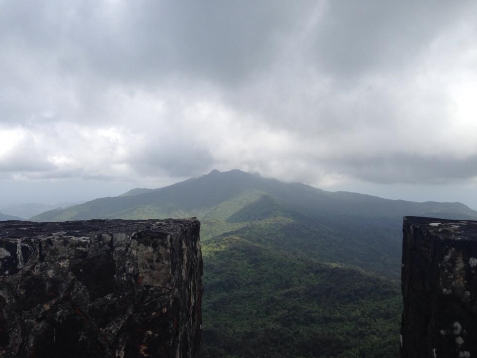 The Atlantic hurricane season runs from June to November. On the northern and eastern slopes, 1400-2500 mm of precipitation falls, on the southern and western slopes – 800 mm of precipitation per year.
Population
Puerto Rico has 3.4 million inhabitants. Large flow of emigration.
Religion – predominantly Catholicism.
Activities, excursions and attractions
Puerto Rico has two beaches, one of which is the Blue Flag Amadores Beach. This beach has many water attractions. Another cozy and beautiful beach, located next to the main walking path, is loved because of the soft golden sand and the numerous restaurants, bars, cafes and shops that are located near the beach.
Particularly popular among vacationers who like to relax with their families is the Atlantis water park. The youngest members of the family will love the Angry Birds Adventure Park. At the resort, golf lovers will be able to enjoy their favorite pastime.
El Unco National Reserve is one of the largest rainforest reserves, preserving Puerto Rico’s pristine nature and widely visited by tourists.
Rio Camai National Cave Park is a karst area in northeastern Puerto Rico. This area is famous for its completely surreal limestone formations and is rightfully considered one of the best places in the world for caving. More than 200 caves have been discovered in this region, some of them have a colossal internal volume, and the Kamai River is one of the largest underground rivers in the world.
In the town of Yabucoa you can find the best beaches, not far from where the natural reserve of Carite begins. Three rivers flow on its territory at once: Rio Grande de Patillas, Rio de Lonsa and Rio de La Plata, the banks of which are very picturesque and ideal for fishing.
The largest water park in the Caribbean is to be found in Puerto Rico, home to Las Cascada, a first-class water entertainment center. This water park is located in an incredibly beautiful natural area, surrounded by green meadows and park areas. The entertainment center fits perfectly into the surrounding landscape, which makes the rest in it even more enjoyable. This water park is not as big as many other well-known water parks in the world, but its territory also has excellent pools and water slides of varying difficulty, interesting attractions for fans of extreme sports and recreation areas for the little ones.
The second largest island of Puerto Rico – Vieques is located 13 km west of the main island and belongs to the group of the Virgin Islands. The island’s unique bays and beaches make it a great place to go diving, snorkeling or simply rowing. Due to its geography and climate, Vieques Bay is one of the most bioluminescent bays in the world.
Cuisine
Spanish cuisine is unique and seafood dominates. The most popular dishes are: paella – a rice dish with seafood and minced meat, arroz negro – a dish with black rice and seafood, gazpacho – a cold soup made from a variety of vegetables. In the region of Atlantic Spain, vegetable and fish stews are popular.
In every tavern, cafe or bar you will be offered light snacks – tapas.
The most popular sweets are: empanadill – sweet or savory cakes, ensaimad – sweet cake, crema catalanna – caramel dessert, turon – sweet made from nuts, reminiscent of halva or grilled meats.
Souvenirs
Cigars and traditional drinks such as rum, Sherry wine, fine coffee, carnival masks and African drums are brought from Puerto Rico as souvenirs.
Vigilance
A necessary evil in Puerto Rico is crime. Much of the crime in the country is related to gangs. But the cities are full of police with powerful weapons and new cars.
Tourist spots, such as Ponce’s downtown square, are controlled by officials from several different quarters.
Top attractions in Cuba
Cobbled streets of colonial cities, coral reefs and fine white sand beaches, national parks with wild fauna, agricultural valleys and ancient fortresses – all these are the main attractions of Cuba. The largest island of the Caribbean attracts travelers with its special atmosphere: national melodies, “hot” gentlemen, retro cars, unforgettable fishing in azure waters. It is simply impossible to cover all the sights of Cuba, a country whose coastline stretches for 3 thousand kilometers, but we will orient you to the most curious ones.
Isolated City
The town of Baracoa was isolated for a very long time: it began to be built at the beginning of the 16th century and only half a century ago was connected to the “mainland” by a long highway. This is one of the pearls of Guantanamo province, where national traditions are carefully preserved.
Colonial-style buildings, secluded beaches, streets literally drowned in lush tropical vegetation (some can lead into the jungle), miniature waterfalls – all this is Baracoa.
A few kilometers from the center of Baracoa is the mesas of El Yunque. Despite the low height (589 meters), it is distinguished by gentle picturesque slopes with unique flora and fauna. This is a nature reserve protected by UNESCO.
Colonial Delights
But this city is included in the World Heritage List because of the careful attitude to the historical past of the country – the local houses of the 17th-19th centuries have been repaired, and the cobblestones of the pavements are loudly knocking under the heels.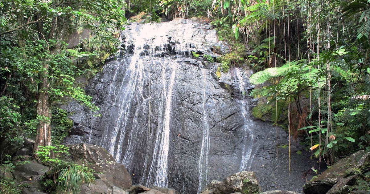 This is Trinidad, which grew thanks to the conquistador Velazquez six centuries ago.
Walking along these streets is a pleasure, but on the Plaza Mayor (main square) you need to stay longer. Several architectural monuments are concentrated here: the monastery of St. Francis (its belfry is especially impressive), a gallery, the Church of the Holy Trinity, a building with amazing frescoes by Brunet Palacio.
Old Havana and its gems
Any tourist who arrives on the island will not be able to miss the main attraction of Cuba – its capital, Havana. You need to take a good look at the Baroque buildings lined up in the Old Havana (Havana Vieja) area, protected by UNESCO. These are fortresses, a cathedral, places associated with the name of Ernest Hemingway, such as the restaurant “La Bodeguita del Medio”
A special attraction of Cuba and Old Havana is Plaza Vieja (Old Square) with several notable buildings – for example, the palace of the Count of Canyongo with stained glass windows.
The turbulent recent past of Cuba – the times when Fidel Castro was young and hundreds of thousands of compatriots listened to his fiery appeals, comes to life on the Revolution Square in Havana. Those interested in the history of the 20th century should not ignore this Cuban landmark.
We still have not left Havana and must make one more stop – in the Park of Military History, where two ancient strongholds rise. This is, first of all, the El Morro fortress, built at the turn of the 16th-17th centuries to protect the city’s water borders. Once upon a time, the local warriors bravely repulsed the attacks of pirates.
Not far from the walls and the impressive lighthouse of the El Morro fortress, you will find its younger sister, Fort San Carlos de la Cabaña, built in the second half of the 18th century. Two centuries later, the headquarters of Che Guevara was located here.
Golden Beach, Varadero
The most famous resort area of Cuba – Varadero – is a peninsula filled with luxurious beaches and almost fifty hotels.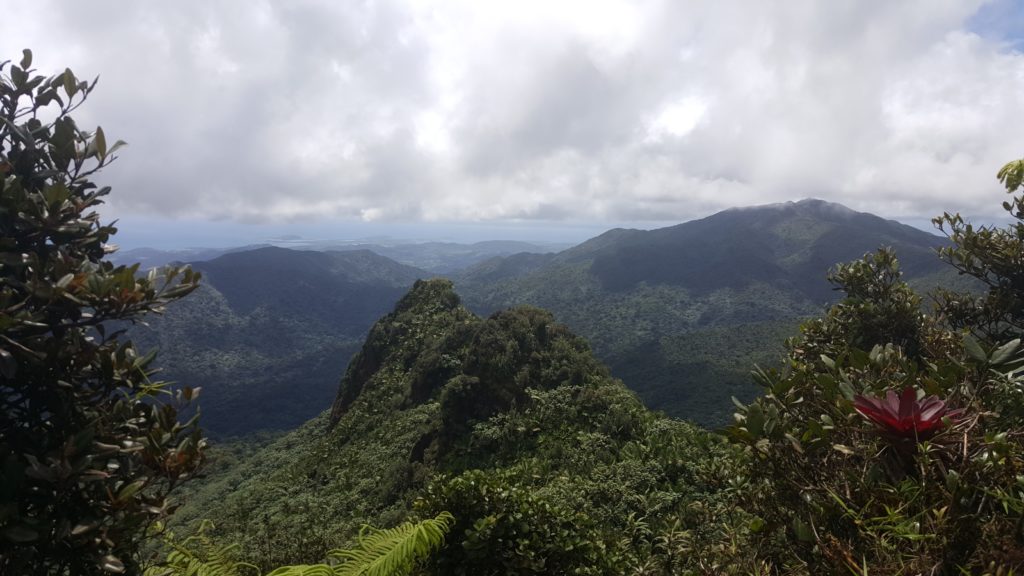 A drawbridge leads to the mainland. White powdery sand licked by turquoise waves and tall palm trees, nature reserve caves and excellent diving sites attract thousands of tourists.
You can look at the colorful marine fauna and the wreckage of ancient ships for hours, but scuba diving is only a small part of the local entertainment, golf, excursions, fishing, skydiving and endless splashing in the clear coastal waters are at your service.
The beaches of the Guardalacava resort are no less good. Exquisite coral reefs with their biodiversity and sailboat trips undoubtedly remain the lure for travelers.
Paradise Beach
Once you get to Liberty Island, you can go to another picturesque attraction of Cuba – Paradise Beach with fine white sand. It is located on the western tip of the cozy little island of Cayo Largo. And, of course, since this is another resort area with hotels for every taste, Paradise Beach is far from the only one, you can find many other charming places and indulge in bliss in the sun.
Fertile valley among the hills
Another World Heritage National Park is the stunning Viñales Valley, nestled among rolling hills and tobacco plantations. Here is a paradise for peasants – they grow not only tobacco, but also tropical fruits and exotic vegetables. Graceful horses graze here (by the way, tourists can practice dressage). Vinales is not very far from the capital, so you can visit the valley and return to Havana by night.
Eden for birds
And finally, let’s talk about another UNESCO reserve, which is also worthy of being included in the rating of Cuba’s attractions – the Cienaga de Zapata Peninsula. In South America, there is the most grandiose swamp on the planet – the Pantanal. And the Caribbean has its own swampy area, and this is Zapata, home to one and a half hundred birds
The reserve is just a godsend for ornithologists (including amateurs) and those who want to watch the “everyday life” of crocodiles.