El yunque tropical forest: El Portal de El Yunque
El Yunque National Forest, Puerto Rico (2023 Guide)
El Yunque National Forest is one of Puerto Rico’s most visited attractions.
El Yunque is the only tropical rainforest in the United States. The forest is home to plant and animal species that can’t be found anywhere else in the world.
I have visited El Yunque many times and can’t wait to share my experiences with you.
In this article, I will tell you everything you need to know about El Yunque National Forest:
– What is El Yunque National Forest?
– Where is El Yunque National Forest located?
– What is the best way to get to El Yunque National Forest?
– What is unique about El Yunque National Forest?
– How much does it cost to visit El Yunque?
– Can you visit El Yunque without a tour?
– How much time do you need in El Yunque National Forest?
– Is El Yunque National Forest free?
– Is El Yunque worth visiting?
What is El Yunque National Forest?
El Yunque National Forest is a rainforest located in Puerto Rico.
Located in the mountains of northeastern Puerto Rico, the forest covers 28,000 acres.
Yokahú Observation Tower in El Yunque was built in the 1960’s and stands 69 feet tall.
The area is overflowing with outdoor recreation opportunities uniquely curated by Mother Nature herself.
Although it is considered a small rainforest, it is one of the world’s most biodiverse.
El Yunque reserve is a habitat for many unique tropical plants. Several endangered species that live here are not found anywhere else in the world.
Below is a video showing El Yunque National Forest:
Where is El Yunque National Forest located?
El Yunque National Forest is located on the northeast side of Puerto Rico.
El Yunque is nearby the beach town of Luquillo, and less than an hour from San Juan.
Drive 1-hour drive southeast of San Juan to the Luquillo Mountains to find El Yunque.
Below is a Google Map that shows the location of El Yunque National Forest:
What is the best way to get to El Yunque National Forest?
Driving your rental car or taking a guided tour is the best way to get to El Yunque.
The winding roads through El Yunque can be narrow at times, but are mostly paved.
There is no public transportation to the forest.
Generally, taxi or Uber are not allowed into El Yunque for drop-offs or pick-ups without special permits.
Additionally, there is little to no cellular service in the forest, making it nearly impossible to contact a taxi or Uber for return service.
What is unique about El Yunque National Forest?
Below are seven facts that make El Yunque like no other place in the world:
1. El Yunque is the only tropical rainforest in the entire US National Forest registry.
There are many opportunities to swim in the forest, remember to bring a towel and bathing suit.
2. The forest serves as a buffer zone against hurricanes.
Thus, making it an essential part of Puerto Rico’s ecosystem.
The forest and its mountains serve as a buffer against strong winds for nearby coastal areas.
3. The Forest is home to Puerto Rico’s most popular waterfalls.
La Coca falls has an incredible 85-foot drop.
La Coca falls is a great place to take photos, located at Road 191 km 8.1.
4. It’s believed El Yunque was considered a sacred mountain by the Native people of Puerto Rico.
Yunque could be related to the word Yuke, which translated to “white lands” in the Taíno language.
Sierra Palms (pictured here in El Yunque) are generally found in the highest mountain peaks in Puerto Rico near creeks and streams.
5. El Yunque is home to over 4,000 species of plants and trees.
Fifty species of mammals, over four hundred species of birds, and forty species of reptiles and amphibians reside in El Yunque.
The Coqui is a very small frog that produces a unique sound you will hear while walking through El Yunque.
6. Many endangered species live exclusively in El Yunque.
The Elfin Woods Warbler, the Puerto Rican Boa (non-venomous), five species of Coquis frogs, the Iguaca, and the rare Lepanthes Eltoroenis are a few of them.
View this post on Instagram
A post shared by Mitchell Pruitt (@mitchell_pruitt)
Photo Credit: @mitchell_pruitt
7. The El Yunque reserve is home to the only Iguaca Aviary in the world.
The parrot is one of the 10 most endangered bird species in the world. In 1975 only 13 existed in nature. Here, they are cared for and bred.
However, this sacred aviary is not open to the public.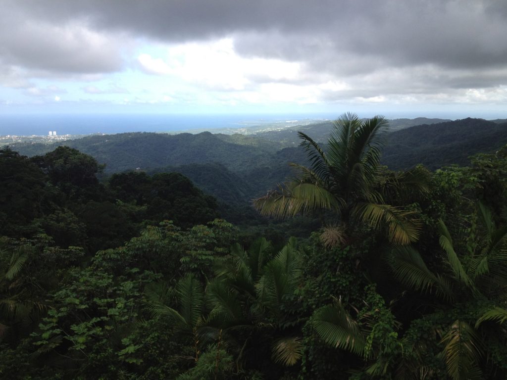
Below is a video showing the Iguaca:
How much does it cost to visit El Yunque?
Register at least 24 hours in advance to visit the main recreation area. There is a small processing fee.
El Portal Visitors Center requires a small entry fee of less than $10 for adults. Children under 15 are free.
View this post on Instagram
A post shared by Una Jíbara Descubriendo A 🇵🇷 (@jibarapr78)
Photo credit: @jibrarapr78
At El Portal, you will find visitor information, a gift shop, a theater, a cafe, ranger-led opportunities to see the Igauca Parrot, and bathrooms.
This is a great spot to recharge for those not-so-extreme explorers.
Afternoon rainstorms are frequent, so be prepared with adequate gear to protect your valuables.
Food, transportation, and lodging will be your biggest cost when it comes to visiting El Yunque.
Guided tour prices vary greatly from around $65 to $100 so it’s important to take your time to shop around.
Can you visit El Yunque without a tour?
Yes, however, you will definitely need your own car.
Yokahú Observation Tower is an excellent stop on your drive.
Drive to the visitor center, then to La Coca falls and on through to the Yokhaú Tower to catch 360 views of the forest.
Several hiking trails of various levels of difficulty exist in El Yunque. Some are paved trails and others are more challenging; think muddy, wet, and slippery. Sneakers or hiking boots are recommended.
Don’t underestimate the trails, some can be considered a bit treacherous.
Many paved walking trails line the forest, which you can explore without a tour.
A forest ranger is available at the visitor center. Ask about the current conditions or warnings in effect on the various trails.
You can also do your own research by checking the USDA El Yunque National Forest website for up-to-date alerts and advisories.
Below is a Google Map showing popular attractions in El Yunque:
How much time do you need in El Yunque National Forest?
Two hours minimum.
There are many tempting opportunities to stop and frolic in the mountain waters or take amazing pictures if you want to extend your stay.
Baño Grande is a historic spot located across from Palo Colorado at PR 191, km. 11.9.
The park opens at 8:00 am and closes at 5:00 pm.
It’s best to reserve a full day for exploration.
The park is vast, thus, if you desire to fully immerse yourself in El Yunque, consider lodging nearby.
Camping on-site is not available at this time.
The Palo Colorado Recreation Area has an information center and picnic areas.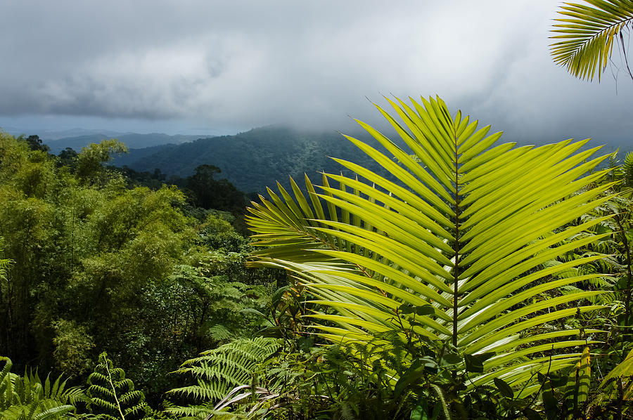
Afterwards, visit Degree 18 Juice Bar located right outside El Yunque for some fresh juice and food to rejuvenate.
Is El Yunque National Forest free?
The main recreation area requires registration and a small fee.
Rope swing at El Angelito swimming area.
But, you can still visit places in El Yunque for free.
Reservations are not required for El Angelito, which is a trail most popular for families with children.
There is a short, easy trail to get there and spots with shallow water. Park only in the designated areas.
El Angelito’s trail and swimming area.
Some of the best bodies of water can be found right outside the reservations area, also free of charge.
Check out rivers and waterfalls near El Yunque Rainforest below:
Is El Yunque worth visiting?
El Yunque is well worth visiting.
Take the rare opportunity to be completely submerged in the rich biodiversity, unique sights, sounds, and colors of the tropical rainforest.
Antillean Crescent Butterfly in El Yunque.
Explore the rainforest’s peaks and literally have your head in the clouds with breathtaking panoramic views.
The unmatched natural beauty of El Yunque’s lush green hiking trails is complimented by a chance to see rare species of plants and animals thriving in their natural habitat.
Pack your hiking boots if you plan on venturing out into El Yunque’s beautiful trails.
Experience the thrill of frolicking in waterfalls, natural waterslides, pools, and rivers of clear mountain water — all steps from what we know as civilization.
Final thoughts
El Yunque National Forest is a must-do for anyone visiting Puerto Rico.
This is a great experience for people that love the outdoors and nature.
While you are in the area, I recommend making a day of it and checking out the nearby beach town of Luquillo.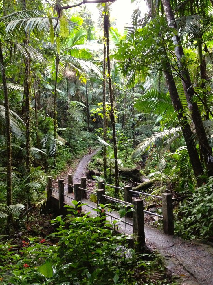
El Yunque is relatively close to a couple of Puerto Rico’s bioluminescent bays. If you have time, you should definitely experience the bioluminescence.
Article by
Tree Alexander
Writer at PuertoRico.com. I have collected countless memories from traveling in Puerto Rico. I share my knowledge of Puerto Rico in my articles. When I’m not writing, I can be found traveling with my toy poodle and homeschooling my children.
About the author
El Yunque National Forest
El Yunque National Forest is a living research laboratory. It is one of the most studied forests in the world and El Yunque has been the home for hundreds of scientific studies and dissertations in a wide range of fields, and today, much of what we know about tropical forests comes from research done in El Yunque. There are many designations that El Yunque has been given that reflect its’ importance to scientific research and forestry:
1956 – The entirety of El Yunque National Forest was designated the Luquillo Experimental Forest (LEF).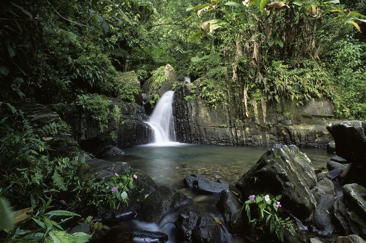 What is an Experimental Forest? The Forest Service’s network of long-term experimental areas, commonly referred to as Experimental Forests and Ranges (EFRs), is the largest and longest-lived ecological research network in the United States. The current network of 84 Experimental Forests and Ranges has been established progressively since 1908; many sites are more than 60 years old. Learn more about the Luquillo Experimental Forest research and history here: https://www.fs.fed.us/research/publications/efr/efr_wo1.pdf
1976 – The entire forest was designated as a Biosphere Reserve, which is an internationally protected area managed to demonstrate the values of conservation. Biosphere Reserves are designated by the United Nations Educational, Scientific, and Cultural Organization (UNESCO) based on nominations submitted by countries participating in the Man and the Biosphere Program (MAB) launched in 1971. As of 2011, there were 564 biosphere reserves in 109 countries (UNESCO 2011). Biosphere Reserves represent voluntary cooperation among people to conserve resources for human benefit. The reserves provide a global network for cooperative research and demonstrate the sustainable use of resources.
1988 – Designated a National Science Foundation Long Term Ecological Research (LTER) Area: Luquillo Long-Term Ecological Research Program (LUQ-LTER) conducts research on ecological issues that can last decades and span huge geographical areas. Luquillo Experiment Forest has represented the only tropical terrestrial site in the LTER Network, with focal research on the effects of long-term climate patterns, intense disturbances (hurricanes and landslides), and forest harvesting on biota and biogeochemical cycling. Learn more here: https://luq.lter.network/
1990 – Designated as a Long-term Ecological Grid, the Luquillo Forest Dynamics Plot (LFDP). Information from the LFDP contributes to the efforts of the Center for Tropical Forest Science (CTFS, Smithsonian) international network of large tropical forest plots in order to improve our understanding of tropical forest and to predict its future.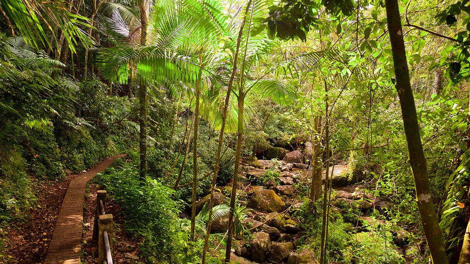 Large plots (typically 50 ha) are required to cover local environmental variation, include sufficient numbers of individuals of both the common and rare species, and to determine plant spatial relationships. Population monitoring is required over many years to elucidate tree life histories, species interactions and population changes in order to determine the forest response to environmental changes and disturbance. Since 1990, more than 170,000 woody stems have been tagged and identified in the LFDP in order to examine the mechanisms promoting species diversity and coexistence in tropical forests, such as competition, heterogeneous environmental conditions, and disturbances (hurricanes and past land use).
2007 – Designated one of 9 Critical Zone Observatories (CZO) studying the “Critical Zone”: Earth’s permeable near-surface layer… from the tops of the trees to the bottom of the groundwater. It is a living, breathing, constantly evolving boundary layer where rock, soil, water, air, and living organisms interact.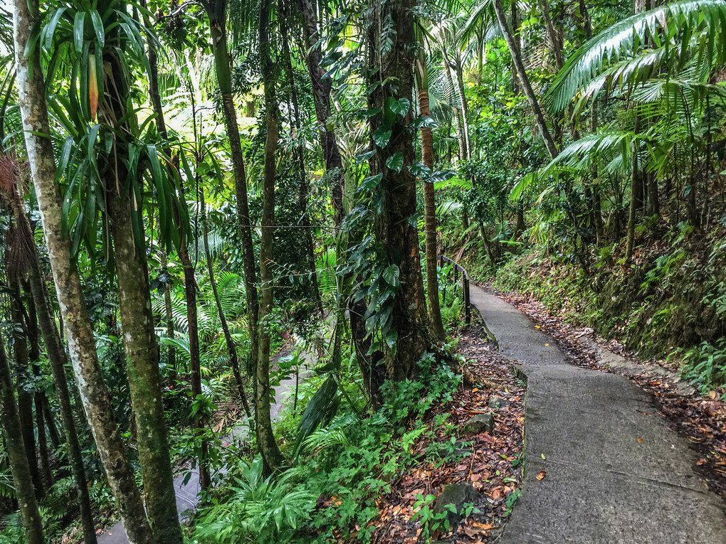 These complex interactions regulate the natural habitat and determine the availability of life-sustaining resources, including our food production and water quality. In El Yunque they study how Critical Zone processes and water balances differ in landscapes with contrasting bedrock but similar climatic and environmental histories. Learn more here: https://criticalzone.org/national/blogs/post/what-is-the-luquillo-czo/
Management: The research aspects of the forest are managed by the International Institute of Tropical Forestry (IITF), headquartered in Río Piedras, Puerto Rico. It is a Forest Service research and technology transfer institute that is dedicated to advancing tropical forestry on insular, national, and international levels, and developing and exchanging knowledge critical to sustaining benefits of tropical forests and grasslands. The Institute has been in continuous operation since its inception as the Tropical Forest Experiment Station in 1939.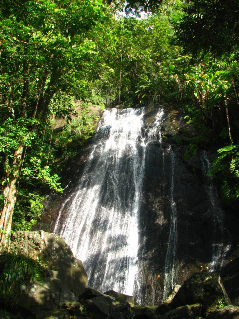 IITF maintains the oldest forest research plots in the hemisphere dating back to the 1940s and maintains continuous growth records on over 20,000 trees. It partners with many organizations and educational institutions to carry out its‘ work. Learn more about the IITF and the research it does: https://www.fs.usda.gov/detail/iitf/research/?cid=fseprd487298
Photo by Gary Potts
Half-American paradise in the Caribbean | Russian Bazaar
Leisure
No. 12 (727)
Eleonora Mandalyan
This small state, measuring 170 km by 60 km, occupies the farthest island of the same name in the Greater Antilles family, which includes Cuba, Jamaica and Haiti. It is curious that the main names of these places are the fruit of delusions and mistakes of the discoverers. The Antilles became because the Spaniards mistook them for Antilia, a ghost island invented and erroneously mapped by the Portuguese in the 15th century.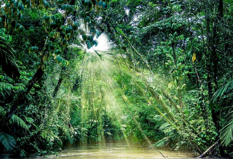 And the entire archipelago and islands separating the Gulf of Mexico from the Atlantic (Bahamas, Greater and Lesser Antilles), with the light hand of Christopher Columbus, as you know, remained the West Indies. nine0009 Thanks to huge coral reefs, the waters of the Caribbean basin, washing the shores of Puerto Rico from the south, are saturated with the richest and most diverse life. Large marine predators are also found here – various types of sharks: bull, tiger, silk, Caribbean reef … But even they cannot scare away divers who come here from all over the world – the tourism industry brings profit to a small state about $ 2 billion a year. Americans usually get to the island from cruise ships, for which Puerto Rico is the final destination. Before boarding a plane and returning home, they, of course, linger on the island – some for a day, some more, to get acquainted with local attractions, sunbathe on snow-white beaches, swim and dive in warm clear waters. nine0009 The climate in Puerto Rico is fabulous – maritime, tropical, mild, except for the ferocious hurricanes that thoroughly registered in the local latitudes and rage from June to November, and warm torrential rains that suddenly fall on the head like an upside down tub.
 There are places here that literally do not dry out all year round. And even when the sun comes up, the locals call it “wet sun”. One such area is in the El Yunque rainforest.
El Yunque is a huge park area in the northeast of the island, which received the status of a Biosphere Reserve under the auspices of the UN. Gorgeous lush forests, rivers, lakes and waterfalls. The kingdom of ferns – up to a hundred species, with fifty species of orchids, 225 species of trees, including mangroves – semi-aquatic trees that feel great even in salty sea water. Landscaped promenades and paths for walking give the rainforest a completely civilized look. nine0009 It is here, in the never-drying thick foliage and grass, that the creature beloved by the islanders lives, elevated by them to the rank of the symbol of Puerto Rico – the green frog “Rico” or “coca”, only 3-5 cm long. Despite their small size, these frogs extremely vocal. You can’t even call their roulades a croak, but rather an “artistic whistle”, in which one theme prevails: “coo-cues, coo-cues”, for which they got their name.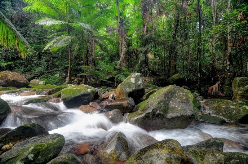
The island of Puerto Rico is surrounded by many small islands and reefs, but of these, only Vieques and Culebra have permanent residents all year round. Mona Island, which is located between Puerto Rico and Haiti, is called the “Galapagos of the Caribbean”, and its flat rocky landscapes are called “Puerto Rican Bali”. Mona’s main inhabitants are giant iguanas, descendants of extinct dinosaurs and mythical dragons. Together with the tail, they reach one and a half meters in length. And also a huge colony of sea turtles, which have been laying their eggs on the beaches for centuries. And yet – feral pigs and goats, the result of a failed attempt to breed agriculture here. nine0009 The waters off the coast of Mona are extremely clear, visibility up to 60 m. And the sea is rich in flora and fauna. There are more than 200 species of fish alone. In addition, the strait between Mona and Haiti is a traditional route for migrating humpback whales. Therefore, diving from its shores is especially attractive.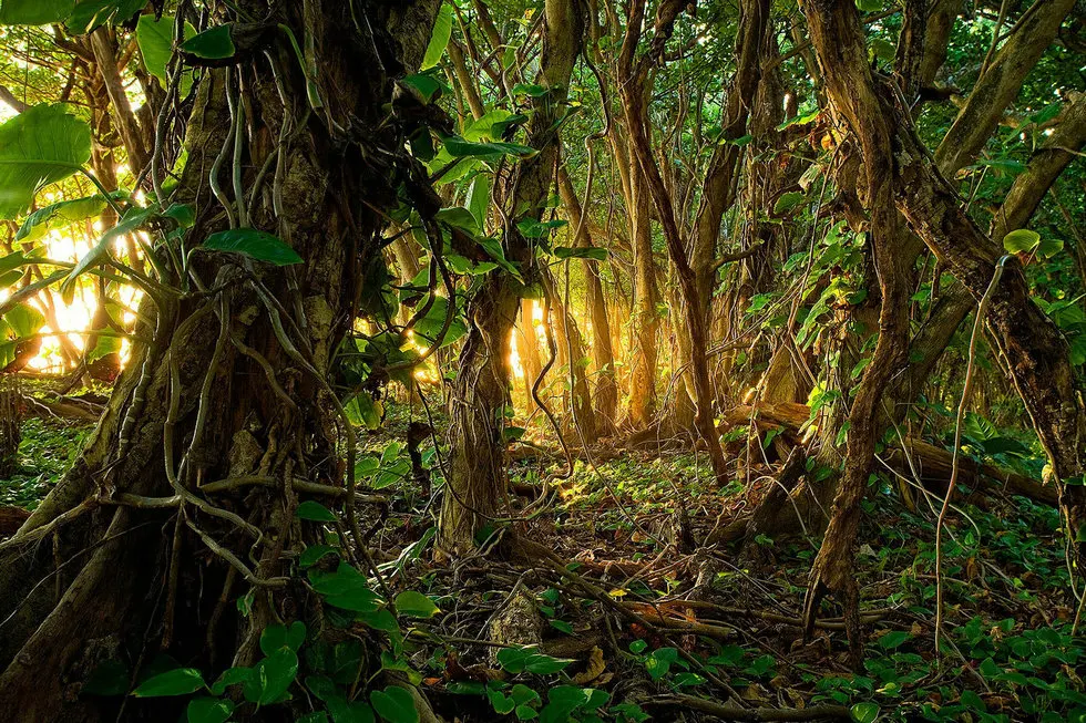 Even the bottom topography is unusual here – huge boulders and rocks, the sheer wall of Pearl Kat with grottoes and underwater caves mysteriously hidden in the darkness, coral reefs, multicolored tropical marine vegetation and its inhabitants. nine0009 Although Puerto Rico is part of the Antilles, which in its geological structure belongs to the mainland, it consists mainly of volcanic, igneous rocks. The Central Cordillera mountain range runs through the middle of the island (by the way, “cordillera” in Spanish is “ridge”), gently descending to the shores. On one of its slopes, among the dense rainforest, there is the Arecibo Astronomical Observatory with the world’s largest radio telescope. This is the US National Center for Astronomy and the Ionosphere, research in which, together with the US National Science Foundation, is being conducted by Cornell University – the initiator of its creation, and funded by the US government. nine0009 Radar observations of the physical processes of the earth’s atmosphere, objects of the solar system and the universe are carried out here.
 Its services are used by scientists from different countries – in the study of pulsars, to search for extraterrestrial civilizations (SETI program – Search for Extra-Terrestrial Intelligence) – the telescope can pick up radio signals at a distance of up to 10 billion light years. But, despite the fact that the giant ear of the Puerto Rican radio telescope is capable of listening to almost our entire Universe, it still has not been able to pick up intelligent signals, although it has been working for the benefit of mankind for almost half a century. nine0009 In America, which has no secrets from its people and from the public in general, everyone can visit any strategic facility, be it a spaceport, naval or air base, attend a meeting of Congress in Washington. This object is no exception, although Puerto Rico is only half American.
At the entrance to the territory, the guards intently examine – with a glance! – each guest and his hand luggage, and that will be limited. For $ 5, those who wish are taken to a specially equipped observation deck on the top of the mountain, from which the entire installation is clearly visible. nine0009 Even those who have never been to Puerto Rico or, having been too lazy to get to the observatory, had the opportunity to see its giant telescope thanks to Hollywood. It has been used, for example, in feature films such as Goldeneye, from the James Bond series, X-files and Contact.
A giant bowl of a radio telescope reflector, the size of 10 football fields, consists of almost 40 thousand perforated aluminum plates (1 by 2 m), laid in a natural karst funnel with a diameter of 305 m and a depth of 50 m. Above the bowl, at a 20-meter height, flanking spherical irradiator suspended on 18 cables from three towers. It is connected to the ground by a flexible sleeve, like a crane (in the photograph inside the “sleeve” the employees of the observatory are visible, they seem tiny compared to this cyclopean installation). Directly under the telescope bowl is a very interesting Museum of Science and Space. nine0009 Near Arecibo, in the Rio Camai National Cave Park, is the gallery of karst caves I mentioned.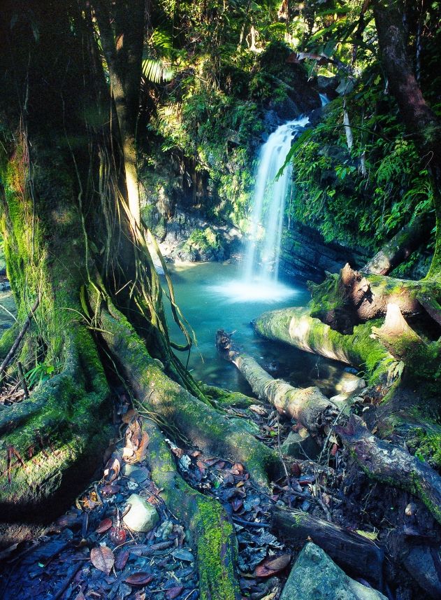 A guest of this island state, if he has a few days of free time, well, you can’t bypass them. Rio Camai is a very ancient river, its age is estimated at a million years. This is one of the largest underwater rivers on the planet. Unlike land workers, such as Colorado, who dug deep canyons for themselves in such a period of time, Rio Kamai chose to go underground, paving and washing out her way from the inside. The result was a very impressive underground water system and over two hundred cavities, some of which are simply gigantic. nine0009 The central cave of the gallery, for example, which lies deeper than the others, has a length of 120 m and a height of more than 20 m. For its solemn appearance, reminiscent of a Gothic temple with vaults lost in the height, it was called the Cathedral Cave.
Tourists walking around the upper floors of the gallery, located 30 m below ground level, see suddenly opening stone windows overlooking the running clouds or the ocean – 16 rock holes connecting the underworld with the ground; hear the noise or roar of water far below, below them.