Fort morro: San Juan National Historic Site (U.S. National Park Service)
Fort San Felipe del Morro
fuerte-san-felipe-del-morro
When you arrive at Fort San Felipe del Morro you will enter through a concrete bridge that goes over the dry moat. In colonial times this used to be a draw bride, which protected the eastern side of the fort. Attacking forces arriving from the east would’ve been met by a dry moat that would have forced them to descend before attempting to climb the fort’s walls.
This gave the Spanish forces several advantages. First, the moat would have protected the base of the fort walls from enemy canon fire, something that never occurred. Secondly, after climbing down into the moat, the attacking foot soldiers would’ve become sitting ducks for the Spanish forces.
Visiting Fort San Felipe del Morro used to be free, but several years ago the National Park Service decided to charge a small fee to help cover the fort’s maintenance and ongoing restoration. The $3 entrance is more than reasonable and if your planning to visit Fort San Cristóbal –which we strongly recommend– you can get a $5 ticket that’s good for both forts during a 7-day period.
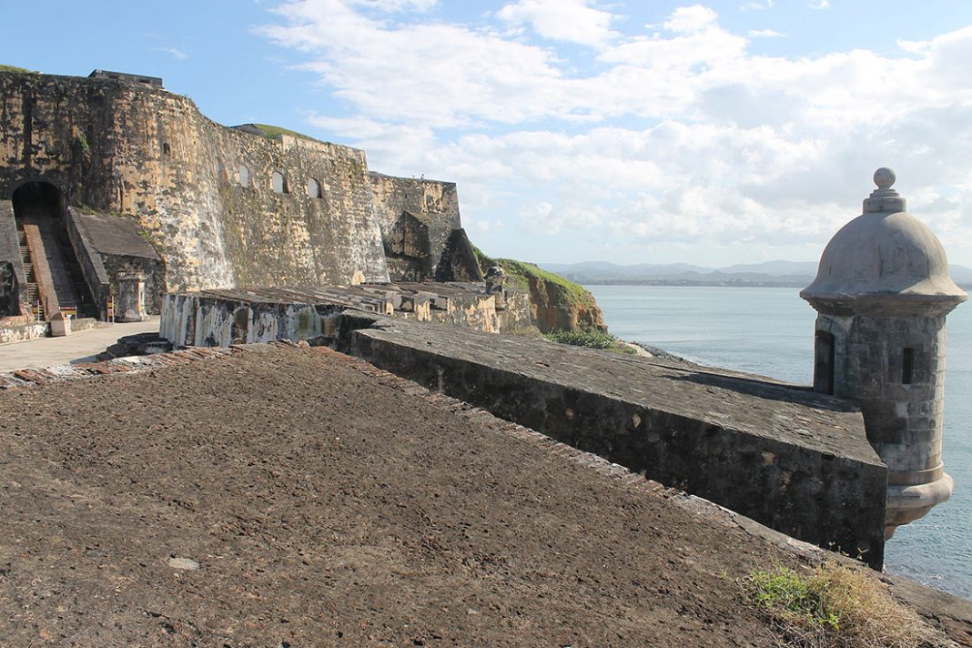
Entering Fort San Felipe del Morro is like taking a step back in history. Once you pass the fort’s massive entrance you’ll find yourself in the main courtyard and you’ll see a tunnel shaped ramp that leads downward towards the Santa Barbara battery.
Immediately to the right of the tunnel shaped ramp there’s a small concession stand with all kinds of books and memorabilia about the forts, Old San Juan and Puerto Rico. On the left side, there’s a small projection room with an audiovisual presentation that covers the city walls and forts. The program is available in English or Spanish during regular park hours.
Now you’ll have to make a decision. Are you going to explore the fort from the top down or from the bottom up. Personally, I prefer to go from the bottom up because you’ll be less tired at the beginning, which is when you’ll be doing most of the climbing.
Now that we have that out the way, lets start down the tunnel shaped ramp towards the Santa Barbara battery level.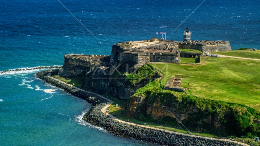 Once again, if you have children in your party, please hold them tightly while you walk down the steps. DO NOT attempt to walk down the center ramp. On missed step and you’ll roll down the ramp like a Spanish cannon ball. By the way, this ramp was called the main artillery ramp and it was used to move cannons weighing up to 10,000 pounds and other military equipment using a sophisticated rope and pulley system called a “block and tackle”.
Once you reach the Santa Barbara battery level you take the next staircase leading down towards the lower patio. Right next to the base of this staircase you will find a passageway on your left that leads to another downward ramp. This ramp leads to the original 1539 tower that today is covered by the Santa Barbara battery. After walking down this ramp you’ll be standing under the dome of original tower, which has several interesting features of its own. Looking to your left you will see yet another ramp that leads to the water-level Water Battery Area. The artillery in this battery would shoot red-hot canon balls at the waterline of enemy ships. The enormous force of these projectiles, and the high temperature at which they were fired, would pierce the ship’s hull, start a fire and allow the sea to pour in.
At the opposite end of the tower you’ll see the closed off longholes from the original structure. Sentries guarding the tower could shoot their muskets and retreat through the narrow tunnel, were they would reload safely under cover.
On the upper right quadrant of the tower dome there is still another piece of history from the fort’s turbulent past. But in this case it’s a real piece. If you look carefully you’ll see a metal fragment sticking out of the dome structure. On May 12, 1898, a month after the United States declared war on Spain, a US naval squadron commanded by Admiral William T. Sampson attacked the city of San Juan for close to three hours. El Morro’s defenses were hit with several hundred shells, one of which pierced the original tower dome.
After walking back up the ramp you’ll arrive at the lower patio. Looking directly under the staircase you will see two large arches directly below the main artillery ramp. The one on the left was the fort’s kitchen and the one on the right was the forge. On the opposite side of patio are the casemates or gunrooms. The guns in these rooms pointed straight out to sea and their mission was to shoot at the hulls and decks of enemy ships. Their enclosed nature made them practically indestructible.
At the center of the lower patio there’s a circular staircase that leads to the third level. If you wish, you can go up this staircase or you can use the wider one that you took on the way down. Either way, you will find yourself right next to the Santa Barbara Battery.
Several years ago you could still see one of the original breech-loading rifled guns that defended el Morro against enemy attackers. Now the Santa Barbara Battery is only a concrete promontory were you’ll have an excellent view of the San Juan de la Cruz fort, sitting across de bay.
Standing at the Santa Barbara Battery with you back towards the sea you will notice the V-shaped design of Fort San Felipe del Morro. On both sides you will see the empty openings were the fort’s guns used to sit.
Walking towards your left along the third level gun area you will find another circular staircase that leads to the fourth level Carmen battery, which supported the Santa Barbara battery. These guns pointed towards the entire western sector of Old San Juan.
Directly across the Carmen Battery there’s a small ramp that goes up around the fort’s lighthouse to the Ochoa half-bastion and the Austria half-bastion. Both half bastions are linked together by a straight wall that sits directly over the fort entrance. This entire area protected the rear side of the fort in the event of a land attack.
When exiting El Morro you’ll probably be struck by the barren appearance of the fort grounds. The Spaniards called this a glacis and the purpose was to deny attacking forces any possible cover from the fort’s gunners and musketeers.
OLD SAN JUAN
Enjoy an adventure through centuries of history.
EL YUNQUE NATIONAL FOREST
Explore the only tropical rain forest in the U.S.
LET’S HIT THE BEACH
Have fun at one Puerto Rico’s world renown beaches.
Disclosure of Material Connection: Some of the links in this post are “affiliate links.” This means that if you click on a link and purchase an item, I will receive an affiliate commission. Regardless, I only recommend products or services that I use personally and believe will add value to my readers. I am disclosing this in accordance with the Federal Trade Commission’s 16 CFR, Part 255: “Guides Concerning the Use of Endorsements and Testimonials in Advertising.”
El Morro | fortress, San Juan, Puerto Rico
Learn about this topic in these articles:
history of Puerto Rico
- In Puerto Rico: Early settlement
…San Felipe del Morro (El Morro) castle, which was perfectly located to dominate the narrow entrance to the harbour.
 Finally they added a stronger and larger fortress (San Cristóbal) to the northeast, on the Atlantic side of the city. In the early 17th century the city was surrounded by…
Read More
 Finally they added a stronger and larger fortress (San Cristóbal) to the northeast, on the Atlantic side of the city. In the early 17th century the city was surrounded by…
“,”url”:”Introduction”,”wordCount”:0,”sequence”:1},”imarsData”:{“INFINITE_SCROLL”:””,”HAS_REVERTED_TIMELINE”:”false”},”npsAdditionalContents”:{},”templateHandler”:{“name”:”INDEX”},”paginationInfo”:{“previousPage”:null,”nextPage”:null,”totalPages”:1},”seoTemplateName”:”PAGINATED INDEX”,”infiniteScrollList”:[{“p”:1,”t”:181754}],”familyPanel”:{“topicInfo”:{“id”:181754,”title”:”El Morro”,”url”:”https://www.britannica.com/place/El-Morro”,”description”:”Puerto Rico: Early settlement: …San Felipe del Morro (El Morro) castle, which was perfectly located to dominate the narrow entrance to the harbour. Finally they added a stronger and larger fortress (San Cristóbal) to the northeast, on the Atlantic side of the city. In the early 17th century the city was surrounded by…”,”type”:”TOPIC”,”titleText”:”El Morro”,”metaDescription”:”Other articles where El Morro is discussed: Puerto Rico: Early settlement: …San Felipe del Morro (El Morro) castle, which was perfectly located to dominate the narrow entrance to the harbour. Finally they added a stronger and larger fortress (San Cristóbal) to the northeast, on the Atlantic side of the city. In the early 17th century the city was surrounded by…”,”identifierHtml”:”fortress, San Juan, Puerto Rico”,”identifierText”:”fortress, San Juan, Puerto Rico”,”alternateTitles”:”El Morro Castle, San Felipe del Morro”,”topicClass”:”place”,”topicKey”:”El-Morro”,”articleContentType”:”INDEX”,”ppTecType”:”PLACE”,”templateId”:4,”topicType”:”INDEX”,”assemblyLinkPrefix”:”/media/1/181754/”},”topicLink”:{“title”:”El Morro”,”url”:”https://www.britannica.com/place/El-Morro”},”tocPanel”:{“title”:”Directory”,”itemTitle”:”References”,”toc”:null},”groups”:[{“type”:”MEDIA”,”title”:{“title”:”Media”,”url”:”https://www.britannica.com/place/El-Morro/images-videos”},”links”:[{“title”:”Images”,”url”:”https://www.britannica.com/place/El-Morro/images-videos#Images”,”target”:”Images-El-Morro”}],”imageList”:false,”flatLinks”:[{“title”:”Images”,”url”:”https://www.britannica.com/place/El-Morro/images-videos#Images”,”target”:”Images-El-Morro”}]}]},”byline”:{“contributors”:null,”allContributorsUrl”:null,”lastModificationDate”:null,”contentHistoryUrl”:null,”warningMessage”:null,”warningDescription”:null,”contributorNames”:”NULL”},”citationInfo”:{“contributors”:null,”title”:”El Morro”,”lastModification”:null,”url”:”https://www.
 britannica.com/place/El-Morro”},”websites”:null,”freeTopicReason”:”TOPIC_IS_INDEX_PAGE”,”topicCollectionLinks”:[],”initialLoad”:true}
El Morro Fort in San Juan Stock Photo ©Bertl123 35566145
El Morro Fort in San Juan Stock Photo ©Bertl123 35566145
Enter the account to see the special offices of November
Images
Video -based music and sounds
Instruments
For business
Our prices
All images
Set up
Download this image,
, Login
I accept the terms of the User Agreement Receive news and special offers
El Morro Fort in San Juan
— Photo by Bertl123
aerial view of a village on the north coast, FranceFrench Atlantic coast near Cap Frehel, Brittany, FranceFrench Atlantic coast near Cap Frehel, Brittany, FranceEtrelle, aerial view of a village on the north coast, FranceLizard is the southernmost point of the UK mainland
.
 Saint Malo City View, France (from the island of Le Grand Bes’
) Aerial view of Florida beach and waterway near Palm Beach Lizard is the southernmost point of the UK mainland
.San Francisco viewBig SurVillage view of Marazion near St. Michael’s Mount, Cornwall, UKThe lizard is the southernmost point of the UK mainland
.French Atlantic coast near Cap Frehel, Brittany, FranceCliffs near Etretat and Fecamp, Normandy, France
Show more
Usage information
You may use this royalty free stock photo of “El Morro Fort in San Juan” for personal and commercial purposes under a Standard or Extended License. The standard license covers a variety of uses, including advertising, UI design, product packaging, and prints up to 500,000 copies. The Extended License includes all uses as the Standard License, with unlimited printing rights, and the use of downloaded stock images for merchandise, resale, and free distribution.
You are using an outdated browser. For a faster, safer browsing experience, upgrade for free today.
El Morro Fort – frwiki.wiki
Strong El Morro (full name: Castillo de los Reyes Tres del Morro ) is a fort that protects the eastern side of the entrance to Havana Bay, north of the city of Cuba to Havana. Located on a promontory in front of Old Havana, it is visible from a distance and overlooks the entrance to the port. The fortress was named after three wise men in the Bible.
Summary
- 1 story
- 2 exhibition
- 3 Notes and references
- 4 Bibliography
- 5 See also
- 5.1 Related articles
History
The fort was built between 1589 and 1630 to protect the entrance to the port under the direction of the Italian engineer Juan Bautista Antonelli.
Originally built in response to raids on the port of Havana, El Morro protected the mouth of the port with a suspended chain linking it to the fortress of San Salvador de la Punta, located on the other side of the bay.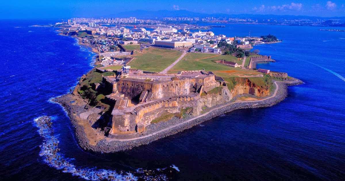 The fortress has walls almost 3 meters thick.
During the Battle of Havana (1762), the British managed to capture it. . Lord Albemarle, landing at Cojimare east of Havana, attacked the fortress defended by Luis Vicente de Velasco y Isla. The British, having dug a tunnel under the ramparts of the bastion and mined the ditch, succeeded in destroying them. When they returned the island to Spain in 1763, the Spaniards decided to build the fortress of La Cabaña to prevent this from happening again.
Exposition
Inside the fortress there is an exhibition about the lighthouses of Cuba: there was once a school of lighthouse keepers in El Morro.
The cannons of the fort are now quite rusty, but the walls are well preserved. The fort has a central four-story barracks. There is also a small exhibition of underwater archeology. Of note are the old toilets that go straight to the sea, as well as two sets of doors and a drawbridge mechanism.