Fun facts about the rio grande river: Things Never Known About Rio Grande | Blog
Rio Grande Facts
Rio Grande Facts
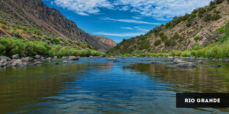
The Rio Grande is the fourth longest river in the United States, flowing approximately 1,896 miles from Colorado to the Gulf of Mexico, forming part of the U.S.-Mexican border along the way. Because its length is debated it is either North America’s fourth or fifth longest river. The Rio Grande watershed (area of land that is drained by the river) is approximately 335,000 square miles. 1250 miles of the Rio Grande make up the United States and Mexican border, an area that has been in dispute throughout history once the region began to be settled by Europeans and Mexico fought for land they believed they owned. In 1944 a treaty was signed between the U.S. and Mexico. The Rio Grande was designated an American Heritage River in 1997.
Other names for the Rio Grande have included Rio Bravo, Keresan (Big River), Tewa (Big River), Tiwa (Big River), and Towa (Great Waters).
The Rio Grande flows from Colorado through New Mexico, Texas, Chihuahua, Coahuila, Nuevo Leon, and Tamaulipas.
The Rio Grande’s major tributaries include Red River, Rio Hondo, Rio Pueblo de Taos, Embudo River, Santa Fe River, Galisteo Creek, Alamito Creek, Terlingua Creek, Pecos River, Devils River, Conejos River, Rio Chama, Rio Conchos, Rio Salado, Rio Alamo, and San Juan River.
The Rio Grande was the physical border in dispute between the Republic of Texas and Mexico in the 19th century. Once the Republic of Texas became a U.S. state the US invaded Mexico, in 1846.
When slavery was abolished in Mexico in 1828, slaves from Texas began to cross the Rio Grande to seek their freedom. The flow of freedom seekers changed and today it is Mexican’s seeking a better life in the United States that attempt to cross the Rio Grande into the United States.
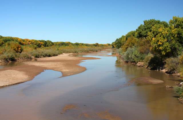
Many dams have been built along the Rio Grande to control the water flow and to divert water for irrigation. This diversion has changed the flow so much that today only approximately 20% of the water reaches the Gulf of Mexico.
Dams along the Rio Grande include Rio Grande Dam, Retamal Dam, Anzalduas Dam, Falcon Dam, Amistad Dam, Caballo Dam, Elephant Butte Dam, and Cochiti Dam.
The Rio Grande was a major steamboat transportation route in the 1800s. There were more than 200 steamboats between Brownsville and Rio Grande City alone.
Steamboats were used during the 1800s to transport military personnel along the Rio Grande during the Mexican War.
Major cities in the United States along the Rio Grande include Santa Fe, Albuquerque, Mesilla, Las Cruces, Truth or Consequence, El Paso, Presidio, Del Rio, Eagle Pass, Laredo, Rio Grande City, Brownsville, and McAllen.
Major cities in Mexico along the Rio Grande include Matamoros, Reynosa, Camargo, Nuevo Laredo, Peidras Negras, Ciudad Acuna, Ojinaga, and Ciudad Juarez.
The Rio Grande has been listed as one of the Most Endangered Rivers several times including in 1993, 1994, 1995, 1996, 2000, and in 2003.
The Rio Grande river failed to reach the Gulf of Mexico in in 2001 when a sandbar formed. In 2003 it once again flowed out to the Gulf.
Related Links: Facts Rivers Facts Animals Facts
Rio Grande Facts
16 facts about Rio Grande
Geography
16 Rio Grande facts
The Rio Grande is one of the major rivers in North America. Once a subject of dispute, it is a natural border between Texas and northern Mexico. The river is slowly drying out and has been declared endangered several times in its history. Presently, scientists and governments try to implement various instruments to preserve the river.
1
It is one of the principal rivers of both the southwestern United States and Mexico.
2
In Mexico, it is known as the Rio Bravo, which means the furious river.
3
It originates in Colorado and flows into the Gulf of Mexico.
4
It is the fourth-longest river in North America.
It is 3,051 kilometers long.
5
The Rio Grande has over 100 tributaries.
The largest in terms of discharge is the Rio Conchos.
6
It is a natural border between Mexico and the state of Texas.
Until 1845, Mexico considered the then Republic of Texas a rebellious territory, when it was annexed into the U.S. It resulted in a Mexican-American War that lasted from 1846 to 1848.
7
The Rio Grande has been an immigration hub for both Mexicans and Americans.
In the 1820s, slaves from Texas got to Mexico through the river after slavery was abolished in Texas. In recent years, it is the other way around. Many immigrants from Mexico have tried to cross the border through the Rio Grande, however, many attempts end in people drowning.
8
Dams built on the river caused the water discharge to get reduced to 20%.
9
It was designated an American Heritage River in 1997.
10
One of the major U.S. cities lying along the Rio Grande is Truth or Consequences in New Mexico.
Formerly known as Hot Springs, the city changed its name in 1950 as a result of a dare of a host of a radio show called Truth or Consequences, who promised free publicity to any city that would change its name to match the shows’.
11
In the 19th century, the Rio Grande was a major transportation route for steamboats.
12
In 2001, a sandbar blocked the flow of the Rio Grande into the Gulf of Mexico.
The situation happened again in 2002.
13
The once widespread fish species called the Rio Grande silvery minnow faces now extinction.
Its population was reduced to 5%, and currently, it can be found only in the middle section of the river. It has been listed under the Endangered Species Act.
14
The Rio Grande is not a navigable river.
Navigation is only possible at the mouth of the Rio Grande.
15
Scientists suggest that if proper management is not implemented in the care of the river, it will dry out completely.
The Rio Grande is overused, as there are more users than the water in the river. What is more, certain parts face droughts and frequently run dry.
16
Because of climate change, water shortages affect the local ecosystem.
Many local species, including the southwestern willow flycatcher and cottonwood trees, are endangered as a result.
The Rio Grande was called the “great river” for a reason. It is the main source of life in arid regions, supplies water to cities and towns, and feeds farms with moisture. It is all the more painful to see the depletion of the once full-flowing and navigable river.
Contents
Origin of the name, history
One of the largest rivers on the continent has an unusual origin. About 50,000 years ago, Lake Cabeza de Vaca broke through the hilly terrain, and the river flowing into it merged with the waters of the Pecos and Rio Conchos rivers – this is how the Rio Grande river was born.
Anatoly Evminov
I am fond of mountain climbing, climbing and mountain tourism. I write essays about climbing activities and hikes in various mountainous areas. I also publish informative articles about natural objects.
Ask a question
The name is also not clear. The Pueblo Indians called the river P’Osoge – “great river”. The Spanish colonialists gave her their name – Rio Bravo del Norte. This hydronym has been preserved in Spanish-speaking Mexico, in America the river is called the Rio Grande.
Before Spanish colonization, the Rio Grande Valley was inhabited by small indigenous tribes. They were hunters, gatherers, nomads, collectively called Coahuiltecan.
period
Events
XVI century
Starting the Spanish colonization
XVII-XVIII century
-964 964
9009 1848
Mexican-American War, establishing the final border between Texas and Mexico along the Rio Grande
1861-1865
American Civil War, Rio Grande – black slave escape route from Texas to Mexico
The end of the XIX-beginning of the 20th century
Bulbed trade and immigration between Mexico and the United States
1911-1916
Mexican Revolution, the Entry of the US Armed Forces to the Region
1944th year
Rio Grande Agreement Concerning Water Rights
1970
Treaty to Resolve Unresolved Boundary Disputes and Maintain the Rio Grande and Colorado Rivers as International Boundaries between the US and Mexico
1994
North American Free Trade Agreement (NAFTA) between the USA, Mexico and Canada, development of cooperation in trade, production and transport 3060 km long, and mainly crosses arid semi-desert landscapes. If in the upper reaches there is enough precipitation, springs and melting snow to support the life of the river, then below there is a lack of nutrition. The average annual water flow, which is 115 m³/sec., decreases to 47.5 m³/sec towards the lower reaches.
Precipitation is unstable, low-water tributaries can not cope with the filling of the channel, but still in September-October there are floods on the Rio Grande. After high water, the river becomes shallow, and, approaching the border, loses almost all of its volume.
The northern, mountainous part of the Rio Grande is located in the temperate continental climate, below dry tropics dominate. The average temperature in January is +7°С, in July – 28°С.
Deep water
4/10
Navigability
1/10
Deep water
1/10
Pollution
5/10
Source, mouth, tributaries, islands it is full of water and cuts through deep, narrow and picturesque canyons. Then it flows through flat arid plateaus, changes direction, and forms a natural border between the USA (Texas) and Mexico to the very mouth.
The Rio Grande flows into the Gulf of Mexico of the Atlantic Ocean and forms a small sandy delta at the mouth. In recent years, a sandbank has periodically formed here, blocking the river’s access to the sea. In fact, the Rio Grande does not flow into the bay every year.
The main tributaries are the right San José, Conchos and Rio Salado, and the left Pecos.
One of the Pecos sites is a protected area.
Reservoirs, hydroelectric power stations, canals
Joint US-Mexican companies were formed to regulate the flow and store water. Large reservoirs were built on the river:
Elephant Butte – the largest artificial reservoir in New Mexico, built in 1916 and having the status of a protected area;
Falcon – international reservoir up to 34 m deep and 97 km long;
La Amistad – located on the border, created by the Amistad dam, which means “friendship” in Spanish.
The first dam to block the river was the Rio Grande Dam, built in 1914. Later, several large projects were developed, under which dams were built on the Rio Grande:
Elephant Butte;
Caballo;
El Vado;
Angostura;
Isleta;
San Acacia.
As well as diversion dams:
Leesburg;
Pepper;
Mesilla;
American;
Riverside.
A number of dams built on the largest tributary, the Pecos River:
Sumner;
Santa Rosa;
Brantley;
Avalon;
Red Bluff.
Many of the hydraulic structures are involved in the production of hydroelectric power.
Settlements
The Rio Grande not only separates the two states, but also connects them. On the US-Mexico border are American and Mexican sister cities. They are located on opposite shores and are facing each other:
Texas
Mexico
El PASO
Del-RIRODIT
Paso del Norte International Bridge
Bridge across the Rio Grande on the border between America and Mexico, connecting the cities of Progreso in Texas and Nuevo Progreso in the state of Rio. The four-lane bridge was built in 1967 and is used for non-commercial traffic to the north.
Otowi Bridge
This wooden bridge was built in 1924. In the 40s, a steel two-lane bridge was erected not far away, but the old building was preserved for history – at 19Otowi Bridge was listed on the National Register of Historic Places in 1997.
Navigation
In earlier centuries the river was an important transport artery. In the 19th century, during the Mexican War, steamships carrying soldiers and ammunition sailed the Rio Grande. However, after 100 years, large ships stopped passing along the river due to its shallowing. The Rio Grande is currently only navigable by small boats with shallow drafts.
Tourism
The semi-desert landscapes along the Rio Grande do not attract much tourists, but in the river valley there are places where travelers from all over the world are happy to come.
Big Bend National Park USA
The park is located in Texas on the border with Mexico. The peculiarity of the relief is the combination of the Chicos mountain range and part of the Chihuahua desert, which determines the diversity of flora and fauna.
As part of a tourist group, you can raft down the Rio Grande, along the bottom of St. Helena Canyon, and spend the whole night on the water, admiring the starry sky from a depth of 457 m.
Off-road car excursions are carried out. For tourists, a hiking route about 30 miles long has also been developed, with a visit to the Sotol Vista observation deck. From here you have a magnificent panorama of the canyon and the Mexican prairies.
The Lost Mine route is dedicated to a folk legend about the search for a silver deposit. Tourists are trying for 5 miles to find the entrance to the mine, allegedly sealed by the Indians.
The Rim Trail is more difficult and takes 1-2 days. The reward for the daredevils will be stunning panoramic views of the mountains and the desert.
Amistad National Recreation Area
This artificial lake offers boating, swimming, water skiing and scuba diving. Experienced scuba divers can explore underwater caves, but these dives are considered dangerous and require special equipment and serious training and education.
In certain places and in accordance with the rules, unusual hunting is allowed – you can hunt white-tailed deer, mouflon, black antelope, audada sheep with a bow. Shotguns are allowed to hunt quails, pigeons, ducks and rabbits.
Given the geographical location of the lake, here you can relax on the water all year round.
Attractions
The Rio Grande Basin contains reserves and national parks, each of which is a landmark of the region:
Atascos Lagoon National Wildlife Refuge;
Santa Ana National Wildlife Refuge;
Bentsen Rio Grande Valley State Park;
Rio Grande National Reserve;
Big Bend National Park;
Elephant Butte Lake New Mexico State Park.
City of Santa Fe
One of the oldest cities in America with a large number of ancient temples and architectural monuments. It is here that you can see the pueblo adobe houses, tourists can visit the modern eco-villages of the Iortship.
City of Taos
Taos is considered the center of Indian culture, there are even preserved Indian buildings of the 15th century. And it is also a city of people of art – at the beginning of the 20th century a large art colony was formed here, there are 3 museums and about 70 art galleries in the city.
City of El Paso
Formerly an adventurous city that has retained the historic landmarks of the “Wild West”.
South Padre Island
Famous for its magnificent sandy beaches, the longest bay in the world.
Port Isabel Lighthouse
The only lighthouse in Texas open to tourists.
Interesting tourist sites are the Elephant Butte and Falcon reservoirs, as well as the Brownsville Matamoros border bridge.
Flora
Fertile lands are located along the upper and partially middle reaches. Below, in semi-desert areas, characteristic desert plants grow:
cactus;
yucca;
prosopis;
creosote bush.
In general, the flora of the Rio Grande Valley is very diverse. A large number of rare trees and shrubs grow on the banks. In the Big Bend National Park, relic forests of the Pleistocene era have been preserved.
A special place in the flora of the river is occupied by medicinal plants, there are up to 20 thousand species.
Fauna
The ichthyofauna of the Rio Grande is also rich – river shrimps, various species of trout, including pygmy, about 1000 other species of fish, turtles live here.
Of the many animal species, the vicuña and alpaca are the most common.
There are about 2000 birds in the Rio Grande basin. More than half of the avifauna of North America lives in Big Bend Park alone – 434 species, including large representatives of the ostrich family – rhea.
Ecology
Environmentalists call the situation with the Rio Grande a catastrophe. Intensive water intake for irrigation of fields makes the river smaller and smaller, in some places it can be forded. Global warming also contributes to the disappearance of the watercourse.
No more than 3% of the flow reaches the mouth of the Rio Grande, and the resulting sandbar prevents the river from reaching the bay. The once fertile delta has practically disappeared, putting many species of birds, fish, and animals on the verge of extinction.
Interesting facts
There is another river called the Rio Grande. It is located in South America, in Bolivia, and is a tributary of the Mamore River.
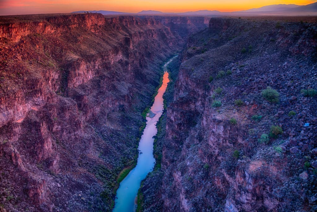
The depth of the canyons in the Rio Grande Valley reaches 450 m, the deepest of them is in Big Bend Park – 520 m.
The Rio Grande has been designated an American Heritage River and two stretches of it have been designated a Wild and Scenic River.
The best classic western “Rio Grande” with John Wayne takes place on the banks of the river of the same name.
In the 19th century, black slaves fled across the Rio Grande from Texas to Mexico in search of freedom, but now illegal immigrants flow from Latin America to the United States in search of work.
Disasters
Continuation of the theme: in the last few months alone, several attempts to illegally cross the Rio Grande have ended tragically. In September 2022, when the water rose by two meters in a day, 9 people died, 37 were saved.
Where is the Rio Grande?
Where does the Rio Grande begin?
Where does the Rio Grande flow into?
Big Bend National Park – our trip along the Rio Grande (Texas, USA)
Big Bend (Big Bend) Mexico, where two countries and different cultures meet. Here, in the midst of a desert landscape with wooded mountains, along the meandering Rio Grande and its canyon-clad tributaries, lies a veritable geological wonder of marine fossils, prehistoric fossils and a variety of flora and fauna. It was very interesting for us to visit there and not only see flowering cacti, but also follow the migration of rare birds and wild animals. 9Ol000
1.6 Where to sleep
1.7 Internet and mobile communications
2 Our visit to Big Bend Park
2.1 Hike Santa Elena Canyon Trail
2.2 Scenic road
Location of Big Bend National Park
The main feature of this US national park is its location along the US-Mexico border along the Rio Grande. The course of this river in this area has a bend and steep banks, indented by picturesque canyons.
Big Bend Park Canyon
We’ve seen a curve like this before when we drove into the famous Horseshoe Canyon before sunset on our way to one of Arizona’s premier natural wonders, Antelope Canyon. But in Texas it was very different. This is a larger scale, noticeable only from a height or on maps, a giant turn in the riverbed of the Rio Grande.
The territory of Big Bend Park, in contrast to the generally rather monotonous territory of the state of Texas, combines several landscapes and natural areas on its territory.
Hiking trails in Big Bend Park are very scenic
There is a desert, a river, canyons and Chisos Mountains (altitude 2387 meters). And on the territory of Big Bend Park, dinosaur bones were found, as in Dinosaur National Monument, located on the border of Utah and Colorado.
The territory of Big Bend Park is very diverse
One of the so-called “heavenly islands” (Island-in-the-sky) is also of great interest. These are isolated mountain formations that rise above the lower terrain in relation to them and differ radically from it in their unique ecosystem.
Interesting fact: From the Big Bend National Park you can get to Mexico. The park has a border crossing Boquillas Crossing. It is open from 8 am to 5 pm (November 2 to April 30 daily, except Monday and Tuesday) and from 9am to 6 pm (from May 1 to November 1 on Fridays, Saturdays, Sundays and Mondays). For a list of documents required to cross the border and requirements for persons wishing to cross it, see the US Customs website (link).
Boquillas Crossing
Getting to Big Bend Park
Big Bend is one of the largest (over 3,200 sq km), isolated and least visited parks in the US. Indeed, to get here, you need to really want to. There are no large cities nearby, let alone large transport hubs.
Important to know: The nearest cities with hotels are 70 km from Big Bend Park, and you will have to drive 350-400 miles all day to megacities.
Two roads lead to the park: 118 from the town of Alpine and 385 from Marathon. The nearest major highway is 10, which leads to El Paso to the northwest (330 miles) and San Antonio to the east (450 miles).
Scheme of roads leading to Big Bend National Park
You can’t get to Big Bend by public transport, it simply doesn’t exist there. You have to go by car.
Our recommendation: to choose a car in the USA and compare prices from different car rental companies, we use the website Rentalcars.com →
its territory can be replenished with fuel.
Read also about our car rental experience in the USA: New York and Miami.
We rented a Full Size Dodge Charger at LAX (read our recommendations here) and went on a road trip through the US Southwest, back to Joshua Tree and Death Valley. On the way to Big Bend Park, we stopped in the Guadalupe Mountains to go on a couple of interesting hikes.
See also:
California Driving Route
Big Bend Park Maps The territory of Big Bend Park is conditionally divided into several parts.
The most popular for visitors are the mountainous Chisos Basin located in the center and the river Rio Grande Village in the west, as well as Castolon – an area with canyons in the southeast. Each of them has equipped trails for walking, places for rest and picnic.
Map of Big Bend
Map of Chisos Basin
Map of Rio Grande Village
There are five major roads in Big Bend that connect the three centers and several dirt roads.
Visitor Centers and Opening Hours
Big Bend National Park is open 24 hours a day, including holidays.
There are 5 visitor centers on the territory of Big Bend Park, where you can get all the necessary information about visiting the park from rangers working there:
Panther Junction (8:30 am – 5:00 pm)
Chisos Basin (8:30 am – 4:00 pm)
Persimmon Gap (temporarily closed)
Castolon (November 1 – April 30, 10 :00 am – 4:00 pm with lunch break)
Rio Grande Village (November 1 – April 30, 10:00 am – 4:30 pm with lunch break)
For the latest information about Big Bend, see official website: www. nps.gov/bibe/
The visitor center in Big Bend Park tells not only about geology, but also about local flora and fauna
Weather and best time to go
The weather in Big Bend Park is not as changeable as in the Rocky Mountains, but you should still be prepared for surprises. In the desert, it sometimes rains and strong winds. However, in general, the climate is quite pleasant, especially in spring and autumn, when it is not very hot, but not cold either. But you need to be prepared for a fairly strong sun and make sure not to get burned.
Weather in Big Bend Park
When we were there in April, during our visit in the mountains, the temperature during the day was about 17 degrees, and along the river, where we camped overnight, it was much warmer.
Big Bend Park can get quite chilly in the morning
Our tip: When visiting Big Bend Park, dress appropriately for the weather – wear comfortable clothing and comfortable shoes. In summer, you need to be careful not to overheat, as the days are quite hot. A wide-brimmed hat will help protect you from the sun.
Also don’t forget sunscreen. And in winter, it is necessary to wear multi-layered clothing, since the air temperature can be around zero early in the morning, and rise to 30 degrees in the afternoon.
The air temperature in Big Bend Park also depends on altitude. So, for example, in the Chisos mountains it can be 20 degrees lower than along the Rio Grande. So before heading out on a hike, carefully check the weather forecast for the day (or ask the rangers at the visitor centers for recommendations) to dress appropriately for all weather conditions (current, forecast) and maybe even have a spare just in case. clothes.
Recommendation: When visiting Big Bend Park, always carry drinking water with you at the rate of 4 liters per person per day.
Advice on how to avoid heavy traffic in the park:
Due to the growing popularity of nature trips during the holidays among Americans, Big Bend National Park is sometimes crowded with visitors, just like well-known parks Yosemite and Zion.
Most of the people in Big Bend are from January to April, and especially during the spring school holidays. Campsites are crowded at this time, and in the most popular parts of the park, such as Chisos Basin, Hot Springs and Santa Elena Canyon, car traffic is restricted during the day. Therefore, it is better to come to the park on peak days early in the morning, and during the day try to drive less through its territory.
Ticket prices
Big Bend Park entrance ticket will cost $15 per person (for those who enter on foot or by bike).
For those entering by car, the ticket price is $30 per car.
Motorcyclists pay $25. The ticket is valid for 7 days.
There are also several days a year when all US national parks are free (check →)
Good to know: if you have one Annual Pass America the Beautiful, you can not pay each time for entrance tickets to different parks , as it applies to all national parks and monuments in the United States. Such a subscription can be bought at the entrance to any of the US national parks. It costs $80 and pays off with interest if you visit 4-5 parks.
Where to sleep
Unlike the Saguaro National Park, Big Bend has several equipped campsites and a cozy lodge. You can book a place in them in advance. You can see available dates for an overnight stay at Chisos Mountains Lodge here.
You can also spend the night in hotels located outside the Big Bend park.
Lajitas Golf Resort – the nearest comfortable resort to the eastern part of the park
Riata Inn – Affordable and well-reviewed motel in the Presidio area
Quality Inn Alpine – Our favorite chain hotel with spacious rooms and a good breakfast
See Booking for all hotels near Big Bend: direct link →
Camping in Big Bend Park
For lovers of outdoor recreation in Big Bend Park, there are 4 organized campsites (it is possible to book a place in advance on the Recreation. gov website) :
Chisos Basin Campground (60 places, reserved, 5400 feet, $16) you can see rare birds and wild pigs peccaries
Rio Grande Village Campground (100 seats, reservation available, 1850 feet, $16), we also spent the night here. Large campsite with very good tree shade sites
Rio Grande Village RV Campground (25 sites fully connected)
There are also wild campsites in the backcountry, to spend the night in them you need to get a permit from the ranger in the visitor center in advance. You can also book online (link).
Internet and mobile phone
Mobile phone coverage in Big Bend National Park is limited. It is worth keeping this in mind in advance, before you arrive at the park and go for a walk. You can talk on a mobile phone and try to catch mobile Internet near the visitor center and the lodge.
Fortunately, Big Bend Park, unlike many other national parks in the United States, has free WiFi access at the following locations:
Panther Junction Visitor Center
The Chisos Mountains Lodge
Rio Grande Village Store
Our visit to Big Bend Park
We drove to Big Bend Park on Route 118 via Maverick Junction. And first thing went on a trip down 30 Mile Road Ross Maxwell Scenic Drive which starts at the Castolon/Santa Elena junction and leads into the desert part of the park.
There are many rather interesting trails on the territory of Big Bend Park
On the way we stopped at the visitor center Castolon , the same one that was soon destroyed by a fire that came across the border from Mexico at the end of May 2019 (now it is temporarily working in the surviving house of officers).
This was the building of the Kastolon visitor center before the fire in 2019
Inside there was a historical post office and a shop
Next to the visitor center we saw some interesting exhibits from the past
From the visitor center the road leads us further to the Rio Grande River. On the way to the canyon we stop at Santa Elena Canyon Overlook.
Near the visitor center there are several small houses
Cacti are blooming beautifully
Dry sticks are also happy in spring
It’s worth going to Texas in spring for such photos
At the observation deck there is information about geological processes
Rio Grande River Valley
Hike Santa Elena Canyon Trail
Going to the classic trail Santa Elena Canyon along the Rio Grande River
Trail
The trail is 1.7 miles long and the climb is 248 meters.
After the Terlingua Creek (may be impassable after rains), the uphill climb begins along the banks of the Rio Grande. The height of the coast (limestone) is 460 meters!
Then the descent to the river begins. You need to take shoes that are not afraid to get wet and walk on water, as you may have to ford one of the tributaries of the river.
Picturesque
after a fascinating walk along the cane Maxwell, we dwell on Vyuputvy and we go to short trails.
Santa Elena Canyon Overlook
At sunset (about 7-8 pm, check here for the exact time) we go to Santa Elena Canyon Overlook. After sunset, we go to spend the night at the Cottonwood campsite, where we previously took a place.
Waking up early in the morning, we go to the site overlooking the mountains in the Santa Elena Canyon area and meet the sunrise there.
Then we return to the campsite and have breakfast with the havelins.
Ross Maxwell Scenic Drive
Packing up the tent and driving along the picturesque Ross Maxwell road to the mountainous part of the park. You have to drive 40 miles, it will take about an hour non-stop. Sotol Vista – the best view on the road. Don’t forget donkey ears – Burro Mesa.
Burro Mesa
Sotol Vista
Chisos Basin
Continue along the mountain-climbing Chisos Basin Road. Visitor Center Chisos Basin is open from 8:30 to 16:00. There we had lunch from 12:00 to 13:00.
Chisos Basin circuit
And then two trails went:
Window Trail – 5. 2 miles, climb – 288 meters. Hiking time is 2.5-3 hours. Starts at Chisos Basin Trailhead next to the lodge. This is one of the most popular trails in the mountain area, and some say in the entire park. The trail descends through the hills and comes to a viewpoint on the Chihuahua Desert below. Along the way – a small waterfall, a variety of flowering plants. Back up. The best views are at sunset or start as early as possible, while it is not very hot.
9000 9000 Chisos Basin Loop Trail meters. The sightseeing trail starts at the visitor center. A well-shaded trail, great for a hot day and for exploring the park or after a trip to Okna. There are beautiful views.
Rio Grande Village
After that we went to the river part of the park (Rio Grande Village), where we visited the Panther Visitor Center at the intersection of Gano Springs Rd and Main Park Rd. The Hot Springs trail is 28 miles, 45 minutes drive.
Hot Springs Canyon Trail – 6 miles or Hot Springs Historic Trail – 1 mile, climb 40 meters, starts at Hot Springs Parking Lot. Trail to the mineral hot springs with views of the Rio Grande. The road to the trail is quite narrow and not very good, unpaved.
Then we moved to the Rio Grande Village Visitor Center – 5 miles. It is open from 9:00 to 16:30. Lunch from 12:00 to 13:00.
Finally set up a tent at the Rio Grande campsite ($14). Altitude – 560 meters
Our place at the Rio Grande Village campsite
In the river part of Big Bend Park, we managed to pass two trails that evening. First we drove towards the Boquillas Canyon, stopping along the way at the Boquillas Canyon Overlook, and then drove another 4 miles to the trailhead. We return to the campsite, and there we go on a nature trail to the Rio Grande.
Boquillas Canyon Trail – 1. 2 miles, climb – 69 meters. Located on Boquillas Canyon Spur Road. You need to climb a small hill, and then go down to the river canyon. Most of the haik is along the Rio Grande. Rock formations, unexpected views of the river.
Big Bend Park Road
It was getting darker in the canyon as the sun sank inexorably towards the horizon. So we hurried back to the campsite, from where we went on another walk called the Rio Grande Village Nature Trail to watch the sunset on the top of the hill with a panoramic view of the river.
Rio Grande Village Nature Trail – 0.75 miles, climb – 36 meters, starts at Rio Grande Village. Passes along a wooden deck over a swamp. You can see flowers, Rio Grande and Mexico. Hike is popular at sunset.
0565 Persimmion Gap Visitor Center to continue your journey across the US by car. Our further way lay in San Antonio , the most historical city of Texas – 410 miles (6 hours).
Our review of Big Bend in Texas
Big Bend in Texas is one of the largest, like Yellowstone, but at the same time one of the least visited national parks in the United States. The reason is simple – the remoteness of the park from major cities. But, despite its inaccessibility and deserted territory, it has its own special charm, although it is quite hot in the mountains, and we are very tired. However, the views of the mountains and the flowering desert were very pleasing.
Here are some facts about Big Bend Park:
Big Bend is located in the Chihuahua Desert in South Texas, just before the border with Mexico.
The park got its name from the spectacular bend of the Rio Grande, along which the border runs.
The park is very large, and we started our acquaintance with it from its deserted part, where the Rio Grande flows through the majestic Santa Elena Canyon.
And then there are the Chisos Mountains, which can be seen from any part of the park. Like the Guadalupe Mountains, they rise like an island in the sky above the Chihuahua Desert. These mountains are so isolated that they are called the Chisos Basin. Which reminds that in ancient times there was a sea here.
We visited Big Bend National Park for the first time, but I immediately thought of an ABBA song called Fernando, one of my favorite songs from this band. The song is about two veterans of the war between Mexico and the United States. They lost the war long ago, but they remember the days of their youth.
I remember well the chic trail through Santa Elena Canyon. High walls rise above the Rio Grande, and it flows slowly and calmly along the rocks. We walked along one of the banks, first rising above the river, almost like in Zion Park (Angels Landing Hike), and then went down to the water. Perfect place! Would recommend to anyone who is going to Texas. Although the Rio Grande did not turn out to be a huge river, as the name suggests. Its greatness apparently lies in its significance for history.
We also did an interesting trail in the Chisos Mountains, which is considered the best in the park, called Okno. Not to be confused with Windows in Arches Park. As a result, we went to the canyon, which was created by a large stream. The walk ended with a cliff – a window – from where a view of the desert opens.
Big Bend on the map
What else you need to know about traveling in the USA1 Northern California road trip
How to see the Grand Canyon on your own
Utah National Parks itinerary
Drive from New York to Miami by car – detailed itinerary for 2 weeks
Lake Tahoe – resort in the mountains of the USA
10 Things You Need to Know About San Francisco
0190
New York hotels: http://paikea.ru/new-york-hotels/

 This diversion has changed the flow so much that today only approximately 20% of the water reaches the Gulf of Mexico.


 97°08′43″ W d.
 The Spanish colonialists gave her their name – Rio Bravo del Norte. This hydronym has been preserved in Spanish-speaking Mexico, in America the river is called the Rio Grande.
 If in the upper reaches there is enough precipitation, springs and melting snow to support the life of the river, then below there is a lack of nutrition. The average annual water flow, which is 115 m³/sec., decreases to 47.5 m³/sec towards the lower reaches.
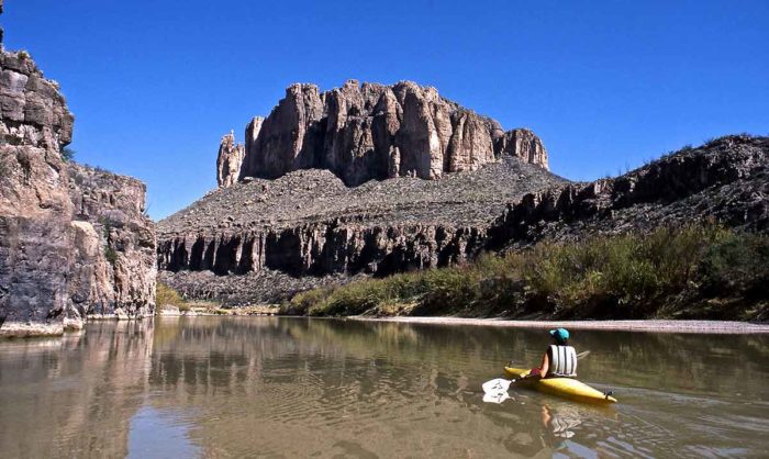
 Later, several large projects were developed, under which dams were built on the Rio Grande:
 The four-lane bridge was built in 1967 and is used for non-commercial traffic to the north.
 The peculiarity of the relief is the combination of the Chicos mountain range and part of the Chihuahua desert, which determines the diversity of flora and fauna.
 Experienced scuba divers can explore underwater caves, but these dives are considered dangerous and require special equipment and serious training and education.
 It is here that you can see the pueblo adobe houses, tourists can visit the modern eco-villages of the Iortship.
/media/img/posts/2014/09/Screen_Shot_2014_09_08_at_1.36.49_PM/original.png) Below, in semi-desert areas, characteristic desert plants grow:
Below, in semi-desert areas, characteristic desert plants grow: Intensive water intake for irrigation of fields makes the river smaller and smaller, in some places it can be forded. Global warming also contributes to the disappearance of the watercourse.
 9Ol000
 The park has a border crossing Boquillas Crossing. It is open from 8 am to 5 pm (November 2 to April 30 daily, except Monday and Tuesday) and from 9am to 6 pm (from May 1 to November 1 on Fridays, Saturdays, Sundays and Mondays). For a list of documents required to cross the border and requirements for persons wishing to cross it, see the US Customs website (link).

 nps.gov/bibe/
 In summer, you need to be careful not to overheat, as the days are quite hot. A wide-brimmed hat will help protect you from the sun.
 Such a subscription can be bought at the entrance to any of the US national parks. It costs $80 and pays off with interest if you visit 4-5 parks.
 gov website) :
 And first thing went on a trip down 30 Mile Road Ross Maxwell Scenic Drive which starts at the Castolon/Santa Elena junction and leads into the desert part of the park.
 On the way to the canyon we stop at Santa Elena Canyon Overlook.
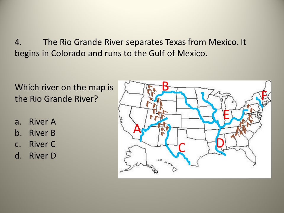 You need to take shoes that are not afraid to get wet and walk on water, as you may have to ford one of the tributaries of the river.
 2 miles, climb – 288 meters. Hiking time is 2.5-3 hours. Starts at Chisos Basin Trailhead next to the lodge. This is one of the most popular trails in the mountain area, and some say in the entire park. The trail descends through the hills and comes to a viewpoint on the Chihuahua Desert below. Along the way – a small waterfall, a variety of flowering plants. Back up. The best views are at sunset or start as early as possible, while it is not very hot.
 The Hot Springs trail is 28 miles, 45 minutes drive.
 2 miles, climb – 69 meters. Located on Boquillas Canyon Spur Road. You need to climb a small hill, and then go down to the river canyon. Most of the haik is along the Rio Grande. Rock formations, unexpected views of the river.
 Our further way lay in San Antonio , the most historical city of Texas – 410 miles (6 hours).
 Although the Rio Grande did not turn out to be a huge river, as the name suggests. Its greatness apparently lies in its significance for history.