Us geographic features: United States (US) geography, maps, climate, environment and terrain from United States (US) |
United States (US) geography, maps, climate, environment and terrain from United States (US) |
Climate:
Mostly temperate, but tropical in Hawaii and Florida, arctic in Alaska, semi-arid in the great plains west of the Mississippi River, and arid in the Great Basin of the southwest; low winter temperatures in the northwest are ameliorated occasionally in January and February by warm chinook winds from the eastern slopes of the Rocky Mountains.
Terrain:
Vast central plain, mountains in the west, hills and low mountains in the east; rugged mountains and broad river valleys in Alaska; rugged, volcanic topography in Hawaii
Natural Resources:
Coal, copper, lead, molybdenum, phosphates, rare earth elements, uranium, bauxite, gold, iron, mercury, nickel, potash, silver, tungsten, zinc, petroleum, natural gas, timber
Note: the United States has the world’s largest coal reserves with 491 billion short tons accounting for 27% of the world’s total
Natural Hazards:
Tsunamis; volcanoes; earthquake activity around the Pacific Basin; hurricanes along the Atlantic and Gulf of Mexico coasts; tornadoes in the Midwest and Southeast; mud slides in California; forest fires in the west; flooding; permafrost in northern Alaska, a major impediment to development
Volcanism: volcanic activity in the Hawaiian Islands, Western Alaska, the Pacific Northwest, and in the Northern Mariana Islands; both Mauna Loa (elevation 4,170 m) in Hawaii and Mount Rainier (elevation 4,392 m) in Washington have been deemed “Decade Volcanoes” by the International Association of Volcanology and Chemistry of the Earth’s Interior, worthy of study due to their explosive history and close proximity to human populations; Pavlof (elevation 2,519 m) is the most active volcano in Alaska’s Aleutian Arc and poses a significant threat to air travel since the area constitutes a major flight path between North America and East Asia; Mount St. Helens (elevation 2,549 m), famous for the devastating 1980 eruption, remains active today; numerous other historically active volcanoes exist, mostly concentrated in the Aleutian arc and Hawaii; they include: in Alaska: Aniakchak, Augustine, Chiginagak, Fourpeaked, Iliamna, Katmai, Kupreanof, Martin, Novarupta, Redoubt, Spurr, Wrangell; in Hawaii: Trident, Ugashik-Peulik, Ukinrek Maars, Veniaminof; in the Northern Mariana Islands: Anatahan; and in the Pacific Northwest: Mount Baker, Mount Hood
Irrigated Land:
102,872 Square Miles
266,440 Square Kilometers
Environmental Issues:
air pollution; large emitter of carbon dioxide from the burning of fossil fuels; water pollution from runoff of pesticides and fertilizers; declining natural freshwater resources in much of the western part of the country require careful management; deforestation; mining; desertification; species conservation; invasive species (the Hawaiian Islands are particularly vulnerable)
Environment – International Agreements:
Party To: Air Pollution, Air Pollution-Nitrogen Oxides, Antarctic-Environmental Protocol, Antarctic-Marine Living Resources, Antarctic Seals, Antarctic Treaty, Climate Change, Desertification, Endangered Species, Environmental Modification, Marine Dumping, Marine Life Conservation, Ozone Layer Protection, Ship Pollution, Tropical Timber 83, Tropical Timber 94, Wetlands, Whaling
signed, but not ratified: Air Pollution-Persistent Organic Pollutants, Air Pollution-Volatile Organic Compounds, Biodiversity, Climate Change-Kyoto Protocol, Hazardous Wastes
Physical Map of the United States
A physical map of the United States that features mountains, landforms, plateaus, lakes, rivers, major cities, and capitals.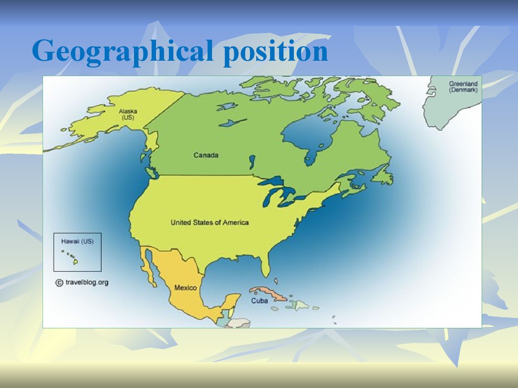 It also includes inset maps for Hawaii and Alaska.
Major Physical Features
Mountain Chains
Rocky Mountains
Appalachian Mountains
Sierra Nevada
Cascade Range
Columbia Mountains
Klamath Mountains
Salmon River Mountains
Black Hills
Adirondack Mountains
Front Range
Ouachita Mountains
Peaks
Trapper Pk.
Borah Pk.
Crazy Pk.
Gannett Pk.
Harney Pk.
White Mountain Pk.
Wheeler Pk.
Uncompahgre Pk.
Longs Pk.
Spruce Knob
Sierra Blanca Pk.
Truchas Pk.
Landmarks
Big Bend
White Sands
Niagara Falls
Grand Canyon
Death Valley (The lowest point in N. America is -86 m)
Deserts
Sonoran Desert
Chihuahuan Desert
Black Rock Desert
Mountains
Mt. Rainier
Mt. Olympus
Mt. Cleveland
Eagle Mt.
Mt. Hood
Mt. Shasta
Slide Mt.
Mt. Katahdin
Mt. Whitney
Mt. Peale
Mt. Elbert
Mt. Rogers
San Gorgonio Mt.
Mt. Baldy
Magazine Mt.
Mt. Mitchell
Plateaus
Columbia Plateau
Colorado Plateau
Ozark Plateau
Edwards Plateau
Cumberland Plateau
Piedmont Allegheny Plateau
Landforms
Superior Upland
Great Basin
Coastal Plain
Mogollon Rim
Llano Estacado
Great Plains
Hatteras Plain
Central Lowland
Central Valley
Major Oceans, Lakes, and Rivers
Rivers
Mississippi River
Rio Grande
Colorado River
Tennessee River
Snake River
Arkansas River
Missouri River
Ohio River
Columbia River
Wabash River
Brazos River
Yellowstone River
Salmon River
Wind River
Minnesota River
Illinois River
Platte River
Republican River
Red River
Canadian River
Pearl River
Altamaha River
Haw River
Conchos River
Hudson River
Gila River
Alabama River
Savannah River
Oceans
North Pacific Ocean
North Atlantic Ocean
Arctic Ocean
Lakes
Finger Lakes
Great Salt Lake
Lake Okeechobee
Great Lakes
Lake Superior
Lake Huron
Lake Ontario
Lake Erie
Lake Michigan
Capes
Cape Cod
Cape Sable
Cape Mendocino
Cape May
Cape Hatteras
Cape Fear
Cape San Blas
Cape Canaveral
Cabo San Lucas
Cape Sable
Water Features
Mississippi Delta
Gulf of Maine
Pamlico Sound
Gulf of Mexico
Straits of Florida
Major Cities
New York
Los Angeles
Vancouver
Chicago
Toronto
San Francisco
Houston
Monterrey
Miami
Seattle
Minneapolis
Detroit
Montréal
St. Louis
Louis
Philadelphia
San Diego
Dallas
New Orleans
Tampa
Sacramento
Denver
Boston
Phoenix
Atlanta
Madison
Lansing
Albany
Concord
Hartford
Providence
Carson City
Lincoln
Springfield
Frankfort
Columbus
Harrisburg
Trenton
Little Rock
Helena
Bismarck
Boise
Pierre
Des Moines
Salt Lake City
Santa Fe
Oklahoma City
Jackson
Nashville
Raleigh
Olympia
Salem
St. Paul
Topeka
Indianapolis
Charleston
Richmond
Montgomery
Columbia
Austin
Baton Rouge
Tallahassee
Jefferson City
Alaska
Cape Hope
Point Barrow
Seward Peninsula
Ogilvie Mts.
Yukon Plateau
Wrangell Mts.
Cassiar Mts.
Kodiak Is.
Alexander Archipelago
Queen Charlotte Is.
Brooks Range
Alaska Peninsula
Alaska Range
North Slope
Chugach Mts.
Mackenzie Mts.
Coast Mountains
Mt. Chamberlin
Mt. Igikpak
Keele Peak
Mt. McKinley
Mt. Logan
Chukchi Sea
Beaufort Sea
Amundsen Gulf
Norton Sound
Bering Strait
Cook Inlet
Bering Sea
Bristol Bay
Gulf of Alaska
Dixon Entrance
Great Bear Lake
Iliamna Lake
Mackenzie Mts
Yukon River
Point Hope
Prudhoe Bay
Barrow
Nome Fairbanks
Dawson City
Fort Good
Hope
Bethel
Anchorage
Whitehorse
Juneau
Cold Bay
Kodiak Sitka
Prince Rupert
Hawaii
Maui Is.
Hawai’i Is.
Moloka’i Is.
Lana’i Is.
O’ahu Is.
Kaua’i Is.
Ni’ihau Is.
Manua Kea
Lihue
Wahiawa
Honolulu
Wailuku
Kailua-Kona
Hilo
geography. Geographical characteristics and features of North America
Home / Regions / North America / Geography of North America
Geography of North America
Click to enlarge North America is also the countries of Central America and the Caribbean, but in our directory they were placed in a separate section for clarity). In addition, North America includes the world’s largest island – Greenland.
Located in the northern and eastern hemisphere, the region is bordered to the north by the Arctic Ocean, to the east by the Atlantic Ocean, to the southeast by the Caribbean Sea and the Gulf of Mexico, and to the west by the Pacific Ocean.
Mountains, foothills, and plains of North America
Source: CIA World Factbook
Alaska Range
These mountains of south-central Alaska extend from the Alaska Peninsula to the border with the Yukon Territory (Canada). Here is the highest point in all of North America – Mount McKinley (height – 6 194 m.).
Coast Range
Mountains along the Pacific coast of California, Oregon, Washington. They also extend along the western border of British Columbia in Canada, and the southern tip of Alaska, all the way to the Kenai Peninsula and Kodiak Island.
Great Plains
The Great Plains of North America descend to the east from the Rocky Mountains, and extend to the border of the Canadian Shield, and the western borders of the Appalachians.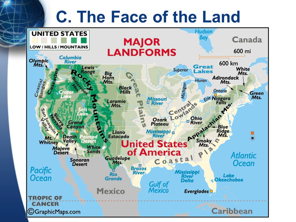 This land is generally flat, with large areas without trees and valleys with shallow rivers. Small hills and mountains are found in the Ozark (Missouri) plateau, as well as in the Boston and Washita mountains northwest of Arkansas and eastern Oklahoma. Sand hills and remnants cover the territories of north-central Nebraska.
Appalachian Mountains
Appalachian Mountains, approximately 2,600 km long, stretch from central Alabama (USA) through the states of New England and the Canadian provinces of New Brunswick, Newfoundland, and Quebec.
Significant Appalachian mountain ranges include: Cumberland (Tennessee), Blue Ridge (Virginia), Allegheny (Pennsylvania), Catskill (New York), Green Mountains (Vermont), White Mountains (New York). Hampshire).
The highest point is Mount Mitchell in North Carolina (height – 2037 m.).
Canadian Shield
Plateau region found in eastern and northern Canada and the Great Lakes region of North America, consisting mainly of uneven and rocky terrain and large areas of coniferous (evergreen) forests. In addition, the northern regions, located along the Arctic Circle, are represented by rocky frozen tundra. The highest elevation, presumably, is 500 meters.
Cascade Mountains
Mountain range extending from northeastern California through Oregon and Washington. Major peaks include Mount Hood, Rainer, and St. Helens.
Continental Divide
In North America, the Western Continental Divide is an imaginary line running through a series of mountain peaks across North America that divides the continent into two major drainage areas.
Atlantic Low
This large area in the southern and southeastern United States extends to the continental shelf, and is generally characterized by plains with forests of various types. Coastal regions contain estuaries and rivers, swamps, swamps, etc.
Rocky Mountains
The Rocky Mountains are approximately 3,000 km long, stretching from the US state of New Mexico, across the western United States, and as far north as British Columbia in Canada.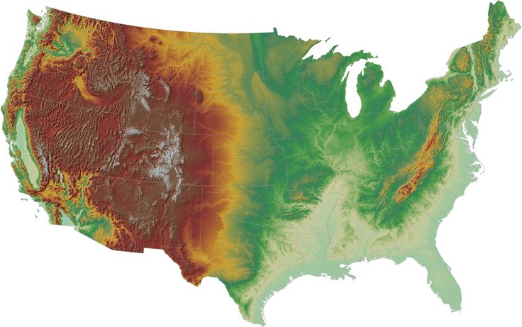
Major mountain ranges in this chain include: Absaroka, Bear River, Beaverhead, Big Belt, Big Horn, Biterroots, Canadian, Clearwater, Columbia, Frant, Guadalupe, Laremy, Lemley, Lewis, Lost River, Medicine Bow, Monashi, Auhi , Purcell, Sacramento, Samon River, San Andres, Sangre de Cristo, Southwatch, Shawshawn, Steens, Stillwater, Swan, Tetons, Unita, Wallowa, Wasatch, Wind River, Wyoming, Zuni.
The highest point in the Rocky Mountains is Mount Elbert, located 15 kilometers from Leadville, Colorado. Its height is 4399 meters.
Sierra Madre
The Sierra Madre includes two large mountain ranges and one smaller one. The Western Sierra Madre runs parallel to the Mexican ocean coast, with some of its peaks exceeding 3,000 meters. The Eastern Sierra Madre runs parallel to the Gulf Coast, with some peaks also exceeding 3,000 meters. The southern Sierra Madre is located in the southern Mexican states of Guerrero and Oaxaca.
Brooks Range
Mountains in northern Alaska. The highest point is Mount Isto (height – 2,760 m.).
Rivers of North America
Source: CIA World Factbook
Hundreds of rivers and their tributaries flow through North America. Some of the largest and most significant of them will be listed and described below.
Brazos
This Texas river rises upstate in Stonewall County and flows south into Brazoria County and on to the Gulf of Mexico. Its length is 1,351 km.
Colorado
Originating in the Rocky Mountains in northern Colorado, this river flows southwest to the Gulf of California. Its length is 2,333 km. Over the centuries, the river has carved many canyons along its meandering path. The most famous of them is the Grand Canyon, in northern Arizona. Along the entire path of the river there are 30 power plants, as well as dozens of dams and reservoirs.
Columbia
This broad, fast-flowing river originates in the Canadian Rockies in southeastern British Columbia, Canada, then flows south through Washington state, then forms a natural border between Washington and Oregon. It ends in the Pacific Ocean, its length is 1,857 km. The development of hydroelectric power in the river basin has brought inexpensive electricity to the people of the Pacific Northwest, but has greatly affected salmon spawning and the migration of native fish.
Mackenzie
This is Canada’s longest river and it divides the Northwest Territories. It flows mainly to the northwest into Mackenzie Bay and the Beaufort Sea. This river of historical significance was discovered by Alexander Mackenzie, and dense green forests grow along its path, and there are dozens of lakes. Its length is 1,800 km. When connected to its tributaries, the Slave, Peace, and Finlay, its total length is 4,240 km, making it the second longest river in North America, behind the Mississippi/Missouri river system (whose length is 6,236 km.) .
Mississippi
This is the main river of North America and the United States, with a length of 3,765 km. It flows from northwestern Minnesota south to the Gulf of Mexico, near the city of New Orleans. It is an important transportation artery, and if connected to its main tributaries (the Missouri and Ohio rivers), it will become the third largest river system in the world, with a length of 6,236 km.
Missouri
This river originates in southern Montana in the Rocky Mountains and flows first north then southeast through the heart of the United States, ending in the Mississippi River, north of St. Louis, Missouri. It is the longest river in the United States (4,203 km).
Ohio
Formed by the confluence of the Allegheny and Monongahila Rivers in Pittsburgh, Pennsylvania, the Ohio River generally flows southwest. It forms a natural border between Ohio and West Virginia, between Ohio and Kentucky, and part of the border with Indiana, Illinois, and Kentucky. It ends in the Mississippi River in Illinois and is 1,569 km long.
St. Lawrence River
This river flows northeast from Lake Ontario and flows into the Gulf of St. Lawrence. It is 1,225 km long and can be used by deep sea vessels between the Atlantic Ocean and the Great Lakes. It includes several artificial canals, castles and dams and is considered one of the most important trade routes on the planet.
Rio Grande
One of the longest rivers in North America (3034 km long), it starts in the San Juan Mountains in southern Colorado, then flows south through New Mexico. It forms a natural boundary between the state of Texas and Mexico as it flows southeast to the Gulf of Mexico. In Mexico, the river is known as the Rio Bravo del Norte. The waters of this river, used by both countries as drinking water, are becoming increasingly polluted as the settlements surrounding the path of the river’s waters grow in size, and dump more and more sewage and pesticides into the water.
Fraser
This river in British Columbia in Canada starts in the Canadian Rockies, then flows in different directions (mainly south), then finally turns west, and ends in the Strait of Georgia, south of Vancouver. Its length is 1,368 km.
Churchill
This river, flowing in central Canada, originates in northwestern Saskatchewan, then flows east into Manitoba, and on to Hudson Bay. It flows through a series of lakes and is known for its fast currents. Its length is 1609km.
Yukon
This river originates in the southwestern Yukon Territory of Canada and then flows northwest across the border into Alaska. This massive river then continues southwest through central Alaska, ending in the Bering Sea. Despite its length (2,035 km.), and the fact that, for the most part, this river is navigable, it freezes from October to mid-June.
Other images of North America
Source: CIA World Factbook
List of UNESCO World Heritage Sites in Russia
Surely you have ever seen majestic mountains and peaceful valleys, meandering rivers and endless forests that took your breath away? There are many such places on Earth. Unique territories that are important to preserve in their original form are included in the World Natural Heritage List. Now it has 203 objects, 11 of which are located in Russia. Only it seems that this is quite a bit: among all countries, Russia ranks fourth in terms of the number of objects after China, America and Australia.
World Heritage Sites include state nature reserves and national parks. Landscapes change from high mountain lakes, glaciers, arctic tundra to alpine meadows, taiga, endless steppes and even volcanoes.
This is not only an incredibly beautiful place, but also home to many species of animals and plants, rare and even endemic – those that are not found anywhere else in the world. One example is the Amur tiger and the Dahurian crane. Some plants on the territory of natural monuments are more than one hundred years old. The age of the cedar in the Teletsk taiga is more than six centuries old.
An object is included in the list if it matches at least one of the following criteria:
(VII) is a natural phenomenon or space of exceptional natural beauty and aesthetic importance.

(VIII) reflects the main stages of the history of the Earth, symbolizes geological processes in the development of the relief or its features
(IX) reflects ecological or biological processes in the evolution of animals, plants and other organisms
(X) includes a significant natural habitat for the conservation of biological diversity and endangered species of exceptional world value
4 out of 11 sites in Russia were selected according to criterion VII: the Komi forests, Lake Baikal, Kamchatka volcanoes and the Putorana Plateau. Therefore, travelers from all over the world seek to see them.
Read the mini-guide to all the UNESCO natural heritage sites in Russia to see them live one day.
1. Komi virgin forests
The largest untouched forests in Europe extend over an area of 32,600 km². This is about 3 km² more than the area of Belgium. The Komi forests are the first Russian site to be included in the UNESCO World Heritage List. Brown bear, sable, elk, more than 200 species of birds, including those listed in the Red Data Book, and valuable fish species such as palia char and Siberian grayling live here.
In the thicket of virgin forests and on the banks of rivers, one can see bizarre stone sculptures, unusual remnants and other forms of weathering, reminiscent of the ruins of castles, or of mythical creatures.
Lush taiga stretches to the Ural Mountains, flowing into the tundra, where there are almost no plants, and crystal rivers descend from the ridges and merge into the Pechora, giving rise to amazing landscapes.
2. Lake Baikal
A slightly smaller area, 31,722 km², is occupied by the deepest lake on the planet. The whole of Malta, even magnified 100 times, would fit on its surface. This is one of the largest World Heritage Sites. The maximum depth of the lake is 1642 meters. This means that if you install the Eiffel Tower at the bottom, and put four more on top, the latter would still not appear out of the water.
The reservoir of the largest lake in Russia is almost 19% of the world’s fresh water. The water in Baikal is so clear that some stones at the bottom are visible even at a depth of 40 meters. In many ways, cleanliness is provided by epishura, a unique crustacean that consumes organic matter. In general, about 2,600 animals live in Baikal, more than half of which are endemic. On the banks of the reservoir there are forests and swamps, glacial lakes, cirques and canyons. There are more than 800 species of higher plants.
A special phenomenon and a real attraction of Baikal is ice. At the end of winter in the bays, its thickness reaches two meters. On different parts of the surface, it freezes in different ways: sometimes it is covered with a web of cracks, sometimes it is dotted with bubbles, it looks like a mirror, sometimes it looks like frosted glass. Ice splashes formed by frozen waves several meters high, and grottoes, which cannot be reached in summer, are striking. On a trip to Lake Baikal in winter, you can go ice skating on a huge lake, raft on an ice floe and fill your camera memory with cool shots.
Baikal is also interesting in summer: you can go on an expedition around this natural monument or have an active holiday with rafting, jeeping and trekking.
See also: Tested on myself: Baikal ice Klyuchevskoy is the highest volcano not only in Russia, but throughout Eurasia (4750 m), Mutnovsky is famous for its smoking fumarole fields, and in the Maly Semyachik crater there is a piercing lake, like a blue eye wide open into the sky. That is why six separate sections of Kamchatka are included in the UNESCO list.
Another unique place is the Uzon caldera. 40,000 years ago, due to several eruptions in a row, a huge volcano collapsed, and a caldera with a diameter of 10 km was formed in its place. It is located on the territory of the Kronotsky Reserve and combines rivers, hot springs, tundra, forests and lakes on the same landscape.
You can see the volcanoes of Kamchatka in summer during trekking or helicopter tours. Want to take cool shots of frozen lava flows, dead forests and ice caves? Go on a photo tour in autumn. You can arrange a trip to the peninsula during the winter holidays. And if you are skiing or snowboarding and you are tired of the standard tracks, try to go down the slopes of the volcano.
See also:
- What is freeride in Kamchatka
- Kamchatka – tested on myself
4. Golden Mountains of Altai
The Altai Nature Reserve and the buffer zone of Lake Teletskoye, the Katunsky Nature Reserve and the buffer zone of Belukha Mountain, as well as the Ukok Plateau have become World Heritage Sites. On their territory there are taiga, steppe, mountain tundra and glaciers, meadows and plateaus. If you want to see all the most picturesque places in one trip to Altai, then choose a car tour. Especially suitable for those who love comfort, because you will spend the night in hotels.
Altai is no less interesting in winter. Going on a snowmobile tour, you will see mountain lakes, snow-covered passes, tracts and cedar forests. After spending the New Year holidays here, recharge your batteries for many months to come. And after making a winter trip to this UNESCO natural site, you will take pictures of the panoramas of the North Chuya Range and see a unique turquoise lake that does not freeze even at very low temperatures.
See also: Tested by myself: Golden Ring of Altai
5. Western Caucasus
The Western Caucasus was included in the UNESCO World Heritage List in 1999. This definition includes the Krasnodar Territory, Adygeya, Karachay-Cherkessia and part of the Main Caucasian Range from Mount Fisht to Elbrus.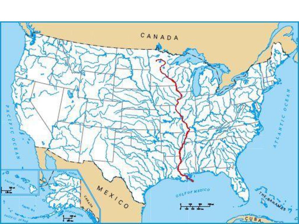 On the territory of the object there are “three-thousand-meter” mountains, bizarre rocks, deep gorges, caves, glaciers and alpine lakes.
Adygea probably has the largest number of natural beauties per square meter. There are only two cities in the republic, and the rest of the territory is mountains and waterfalls, alpine meadows and untouched forests, deep canyons and raging rivers. This makes it possible to engage in various types of outdoor activities in summer, autumn and even winter. Rock climbing and hiking, horseback riding – why not spend the New Year holidays like this?
Dombai and the surroundings of Caucasian Mineralnye Vody have long been known for lakes, waterfalls and springs – they were popular back in the Soviet Union. Unlike Kamchatka and Baikal, everyone can afford to travel to the Caucasus. In addition, summer heat comes here earlier and lasts longer.
See also: Adygea: instructions for use
Here, for example, you can meet both Himalayan and brown bears.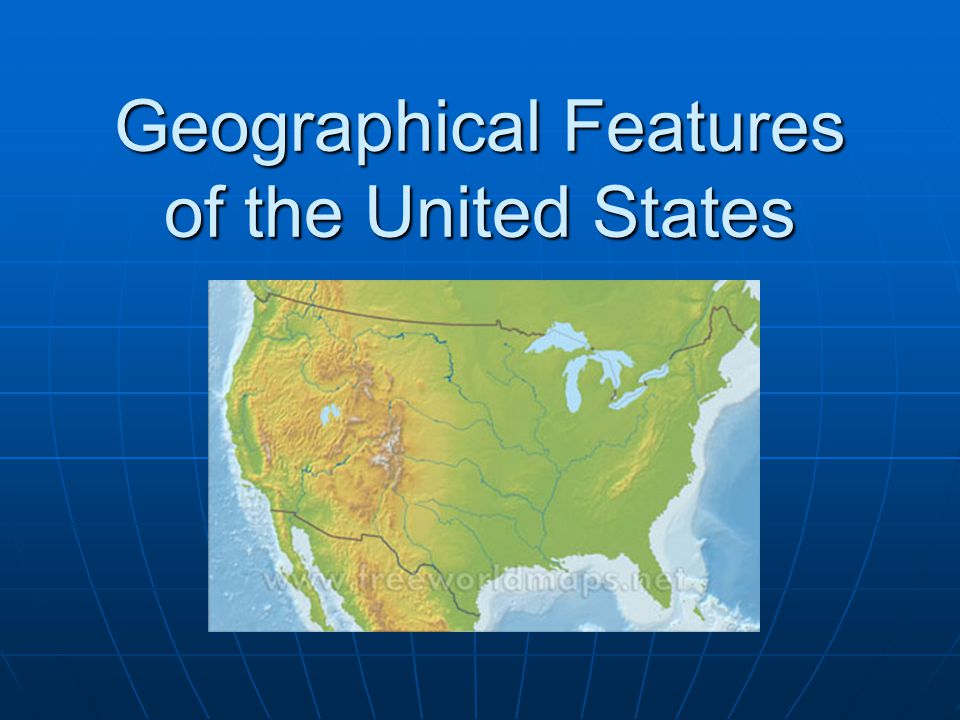 Primorye is a whole world of relics and endemics, where groves of relic yews grow, carpets of Red Book lotuses bloom and rhododendrons bloom – local sakura. Protected bays with white beaches hide starfish and schools of colored fish. At high altitudes, the tundra extends, while in the lowlands the grass grows up to 3.5 meters.
Sikhote-Alin is the birthplace of Amur tigers. Over the past 100 years, their number in the world has decreased by 25 times. At the same time, 95% of the entire population lives in the Far East, and 5% in China. There, killing a tiger is a crime that carries the death penalty. And the Far Eastern leopard remained only in Primorye.
V.K. traveled through the local taiga. Arseniev is a researcher of the Far East. On the expedition, he was with his friend and guide Dersu Uzala, a local hunter. Today you can follow in their footsteps while traveling through Primorye.
See also: Crouching tiger, hidden leopard
On the territory of Mongolia, this lake is the largest, and its Russian part is only 0.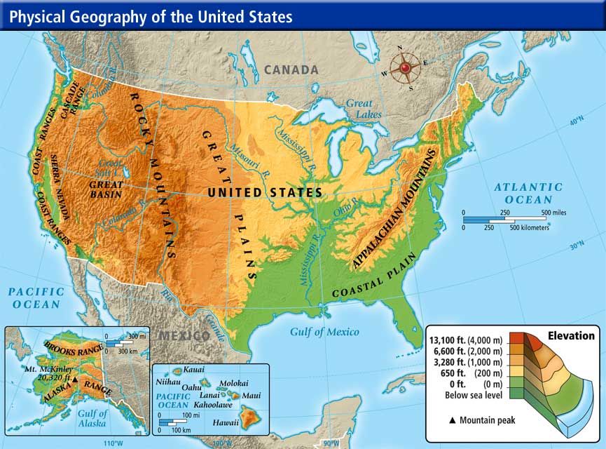 3% of the total area. Here are contrasting landscapes – highlands, mountain taiga massifs, forest-steppe, steppe and semi-desert areas. There is even a real sandy desert. The surroundings of the lake were inhabited several thousand years ago. This is evidenced by petroglyphs on the rocks, stones and burial mounds, of which there are about 40,000 here.
8. Wrangel and Herald Islands
In the very north of Russia, where the Chukchi Sea meets the Arctic Ocean, there are the gloomy and mountainous Wrangel Islands (7.6 thousand km²) and Herald Island (11 km²). In harsh environments where vibrant life seems impossible, there are hundreds of plant species – more than on any other Arctic island. Among the blackening rocks, walruses settled in the largest rookery in the Arctic, and thousands of birds made their nests. Gray whales swim in the local waters during migrations. Vragnel Island is called the “maternity hospital of polar bears” – there are so many of its ancestral lairs here.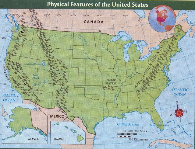 And in Chukchi it is called Umkilir – “the island of polar bears.”
It is worth visiting at least once to see really rare animals. For example, musk oxen, which, like reindeer, survived the late Pleistocene extinction. Their wool is eight times warmer than sheep! Traveling around Chukotka, you can also try whale meat, learn an Eskimo dance and walk along the alley of whale bones.
See also: Sergey Doli’s Journey to Wrangel Island
0002 On the map of Russia, the Putorana Plateau is located just beyond the Arctic Circle, in the geographical center of our country. The web of power lines did not reach here, only satellite phones have a connection, and for many kilometers around there is not a soul. The territory of the plateau has been on the UNESCO list since 2010. It is as if someone had carefully cut off the peaks from the mountains here, and the lakes go hundreds of kilometers long, rather resembling fjords. There are more than 20,000 waterfalls in this region, among which are the highest in Eurasia.
In winter, these waterfalls freeze and turn into giant ice walls that reflect the northern lights. Real magic! You can see amazing landscapes by going on a snowmobile expedition.
In summer you can explore the bottomless canyons and take boat trips on the lakes. Maybe you will even be lucky to catch an amazing natural phenomenon – deer migration. This place has a very special energy. The plateau was formed about 250 million years ago on the site of a volcano, and since then little has changed here. Embark on a journey to experience it for yourself.
See also: Tested on myself: winter on the Putorana Plateau
Tested on myself: Putorana Plateau – 9 discoveries on another planet
UNESCO heritage in 2012. The park consists of two branches: “Pillars” and “Sinsky”.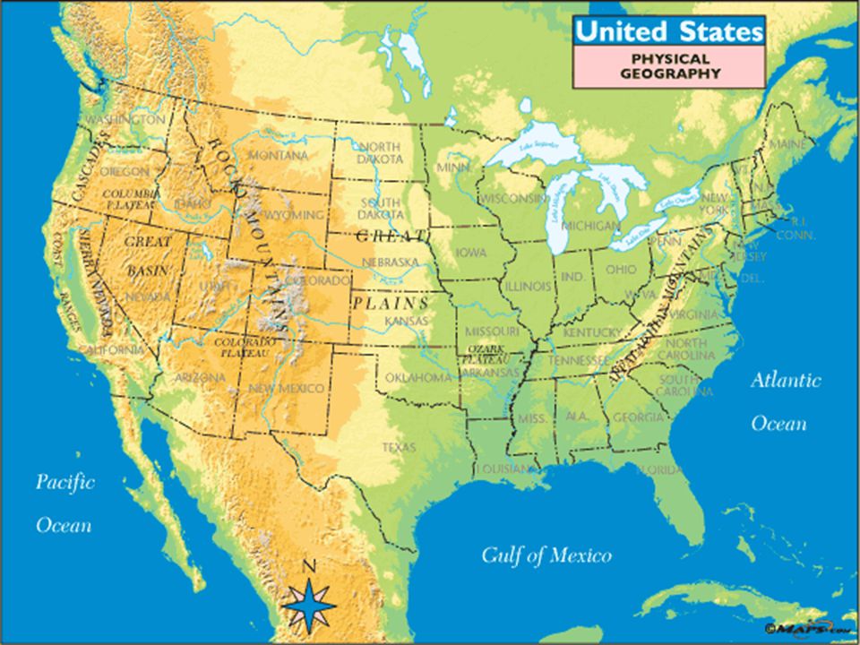 Just imagine: stone towers and arches, bridges and grottoes, animals and birds. And all this was created not by man, but by nature. Such rock formations of various shapes follow in a chain along the course of the Lena River. The forces of water and wind created pillars about 100 meters high (and in some places all 220) several centuries ago.
They cannot be approached by sightseeing bus or car, so those who want to see the bizarre rocks go on a two-week rafting trip. The route also captures the Sinsk Pillars – 37 groups of rocks that precede the mouth of the Sinya River. In winter, you can see this natural monument on an ethnic tour in Yakutia. You will also see special breeds of Yakut horses and cows, ride a dog sled and try traditional Even cuisine .
11. Landscapes of Dauria
This is the only ecoregion in the world where dark coniferous forests turn into temperate continental meadows, a humid climate is replaced by arid.