What city is this zip code: Matching ZIP codes to Cities and Counties
Matching ZIP codes to Cities and Counties
Looking for our list of all us ZIP codes? We offer a complete downloadable list in Excel and CSV format.
Primary, Acceptable, and Unacceptable
When addressing mail, the USPS prefers everyone use the primary city whenever possible.
However, we realize that there are many other uses for this data set so we have included lists of other cities that are recognized by USPS.
Acceptable cities are recognized by the USPS and should not result in delivery delays.
As you will learn below, certain geographic areas are frequently referred to by multiple names.
The boundaries of a ZIP code generally have nothing to do with city limits. ZIP boundaries are set to aid mail delivery.
As a result, the USPS may refer to an area by a name which may be inside an incorporated city’s city limits that uses another name and still have other names that are used in common conversation.
The list of unaccpetable cities may be fine for everyday conversation.
However, using them when addressing mail will likely result in delivery delays.
ZIP Code Boundaries Do Not Match City Limits
One of the most frequent questions we get is related to matching ZIPs to cities.
Remember that the boundaries of a ZIP code generally have nothing to do with city limits. ZIP boundaries are set to aid mail delivery. City limits are not.
Generally, USPS determines a mail route that best suites their needs, they assign a ZIP to that area, and they name the “city” of the ZIP after the post office(s) in that ZIP.
As you can see from the example image, about the only time the city limits and ZIP boundaries match up are across state lines and that isn’t even universally true.
Many ZIPs cross state boundaries.
Think of it this way: if the postal carrier is driving down a road delivering mail and happens to cross the city limits, it makes little sense to have them stop delivering for the rest of the houses on the street simply because the city limits changed.
Instead, they’ll keep delivering along the street to the next intersection or some other boundary that makes more sense to allocating their available resources, i.e. delivery personnel.
ZIP “Cities” Often Aren’t Incorporated Cities
Futher, USPS does not always use the name of the incorporated city in which the ZIP code is located.
The assignment of cities to ZIP codes is more general.
The city is usually the name of the main post office.
The image example of New York, NY illustrates this point. The black outline shows the area of the official city limits.
Every color coded region within is a different ZIP code. ZIPs with the same city according to USPS have the same color.
To avoid overcrowding, only a few labels are shown.
As you can see, the area inside New York city is actually split into many ZIP codes that are each named after different places.
Staten Island, Brooklyn, and Bronx are all famous parts of NYC that can easily be picked out in the example.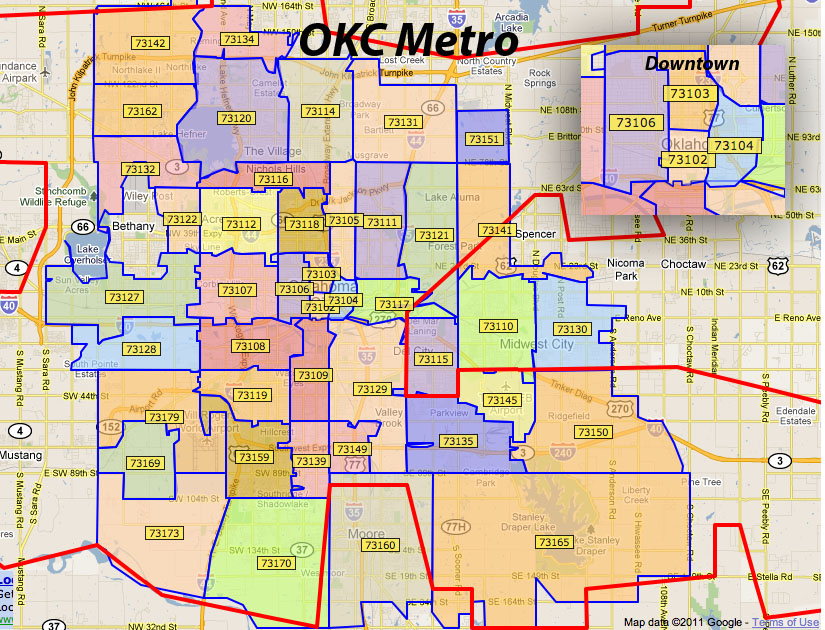 None of them are actually an incorporated city.
However, USPS uses those names to indicate the city for the ZIP codes located in those areas.
Because the area is so densely populated, many different areas within NYC are given names that are not “New York.”
Only a small subset of ZIPs in Manhattan use the designation “New York” even though many others exist within the city limits.
ZIP Codes Include Rural Areas
Official City Limits
Cities According to ZIP/ZCTA Boundaries
Explanation
Remember that people in rural areas outside of city limits still need to receive mail.
So, ZIP codes cover a much larger portion of the land area in the US than city limits.
This coverage is easily seen in the image examples shown for the area around Memphis, TN.
One map shows the color coded areas that make up the official city limits for the various cities in the region.
The second map shows all ZIP codes with the same primary city shaded using the same color.
Notice how many rural areas are grouped with nearby cities because they share delivery resources.
Correctly Matching ZIPs to Cities and Counties
To solve these issues, we have compiled the overlap data between ZIP codes and cities as well as ZIP codes and counties.
We analyzed every block that the Census Bureau assigned within the U.S.
This means that you can determine what percentage of the population of a ZIP code is located within various city limits without complex analysis of tons of addresses, shapes, or areas.
We list the overlap based on area, land area, population, and number of households to suit various use cases.
You get two overlaps as percentages: percentage of the ZIP in an area and the percentage of the area in the ZIP.
Using these numbers you can find the primary city/county for a ZIP or the primary ZIP for a city/county.
To facilitate easier matching, various identifiers of cities and counties are included such as FIPS and ANSI codes.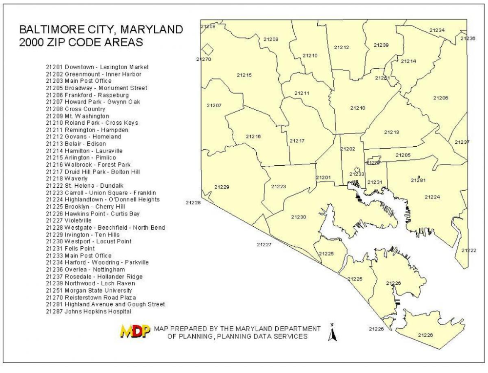
If you are comparing to other data sets with these identifiers, these identifiers avoid complications that arise from matching to cities/counties that are frequently spelled differently.
For instance, DC can be represented as “Washington, DC”, “Washington D.C.”, “District of Columbia”, etc.
However, it will always have an FIPS code of 11.
As another example, St. Louis, MO could be spelled as “St Louis”, “St. Louis”, or “Saint Louis” in various data sets.
However, it will always have a state FIPS of 29 and a place/city FIPS of 65000 which makes the geoid 2965000.
Keep in mind that there may be multiple rows in the data set for a single ZIP – for instance when a ZIP overlaps 2 counties, there will be two rows for that ZIP.
When matching to cities/places, the data file also contains a row for the portion of the ZIP that is outside of city limits.
These rows can be identified because the place_name will be “Outside city limits”, the last 5 digits of the place_geoid will be 99999, and the place_type will be “None”.
Note that not all ZIP codes, cities, or counties will be included in this data file.
Only the ZIPs that are studied by the Census Bureau that are geographically based (approximately 33,000) are included.
Approximately 98% of counties and 95% of cities overlap with a ZIP code and are included.
United States ZIP Code
There are more than 40,000 ZIP codes in the United States. To find a ZIP code, select the state in the list below and you will have access to the list of cities and the map of ZIP codes for the state. Another option is to use the my ZIP code tool which will find your postcode based on your current location.
Choose state to search for ZIP Codes
| State | State Capital | ZIP Range | ZIP Quantity | State founded | ||
|---|---|---|---|---|---|---|
| AL | Alabama | Montgomery | 35004 to 36925 | 838 | December 14, 1819 | |
| AK | Alaska | Juneau | 99501 to 99950 | 274 | January 3, 1959 | |
| AZ | Arizona | Phoenix | 85001 to 86556 | 567 | February 14, 1912 | |
| AR | Arkansas | Little Rock | 71601 to 72959 | 709 | June 15, 1836 | |
| CA | California | Sacramento | 90001 to 96162 | 2653 | September 9, 1850 | |
| CO | Colorado | Denver | 80001 to 81658 | 662 | August 1, 1876 | |
| CT | Connecticut | Hartford | 06001 to 06928 | 438 | January 9, 1788 | |
| DE | Delaware | Dover | 19701 to 19980 | 98 | December 7, 1787 | |
| FL | Florida | Tallahassee | 32003 to 34997 | 1490 | March 3, 1845 | |
| GA | Georgia | Atlanta | 30002 to 39901 | 973 | January 2, 1788 | |
| HI | Hawaii | Honolulu | 96701 to 96898 | 139 | August 21, 1959 | |
| ID | Idaho | Boise | 83201 to 83877 | 325 | July 3, 1890 | |
| IL | Illinois | Springfield | 60001 to 62999 | 1588 | December 3, 1818 | |
| IN | Indiana | Indianapolis | 46001 to 47997 | 987 | December 11, 1816 | |
| IA | Iowa | Des Moines | 50001 to 52809 | 1063 | December 28, 1846 | |
| KS | Kansas | Topeka | 66002 to 67954 | 756 | January 29, 1861 | |
| KY | Kentucky | Frankfort | 40003 to 42788 | 962 | June 1, 1792 | |
| LA | Louisiana | Baton Rouge | 70001 to 71497 | 725 | April 30, 1812 | |
| ME | Maine | Augusta | 03901 to 04992 | 488 | March 15, 1820 | |
| MD | Maryland | Annapolis | 20588 to 21930 | 622 | April 28, 1788 | |
| MA | Massachusetts | Boston | 01001 to 05544 | 703 | February 6, 1788 | |
| MI | Michigan | Lansing | 48001 to 49971 | 1170 | January 26, 1837 | |
| MN | Minnesota | Saint Paul | 55001 to 56763 | 1031 | May 11, 1858 | |
| MS | Mississippi | Jackson | 38601 to 39776 | 533 | December 10, 1817 | |
| MO | Missouri | Jefferson City | 63001 to 65899 | 1171 | August 10, 1821 | |
| MT | Montana | Helena | 59001 to 59937 | 405 | November 8, 1889 | |
| NE | Nebraska | Lincoln | 68001 to 69367 | 620 | March 1, 1867 | |
| NV | Nevada | Carson City | 88901 to 89883 | 254 | October 31, 1864 | |
| NH | New Hampshire | Concord | 03031 to 03897 | 284 | June 21, 1788 | |
| NJ | New Jersey | Trenton | 07001 to 08989 | 731 | December 18, 1787 | |
| NM | New Mexico | Santa Fe | 87001 to 88439 | 426 | January 6, 1912 | |
| NY | New York | Albany | 00501 to 14925 | 2208 | July 26, 1788 | |
| NC | North Carolina | Raleigh | 27006 to 28909 | 1090 | November 21, 1789 | |
| ND | North Dakota | Bismarck | 58001 to 58856 | 407 | November 2, 1889 | |
| OH | Ohio | Columbus | 43001 to 45999 | 1447 | March 1, 1803 | |
| OK | Oklahoma | Oklahoma City | 73001 to 74966 | 776 | November 16, 1907 | |
| OR | Oregon | Salem | 97001 to 97920 | 486 | February 14, 1859 | |
| PA | Pennsylvania | Harrisburg | 15001 to 19640 | 2213 | December 12, 1787 | |
| RI | Rhode Island | Providence | 02801 to 02940 | 91 | May 19, 1790 | |
| SC | South Carolina | Columbia | 29001 to 29945 | 539 | May 23, 1788 | |
| SD | South Dakota | Pierre | 57001 to 57799 | 394 | November 2, 1889 | |
| TN | Tennessee | Nashville | 37010 to 38589 | 796 | June 1, 1796 | |
| TX | Texas | Austin | 73301 to 88595 | 2655 | December 29, 1845 | |
| UT | Utah | Salt Lake City | 84001 to 84791 | 347 | January 4, 1896 | |
| VT | Vermont | Montpelier | 05001 to 05907 | 309 | March 4, 1791 | |
| VA | Virginia | Richmond | 20101 to 24658 | 1241 | June 25, 1788 | |
| WA | Washington | Olympia | 98001 to 99403 | 733 | November 11, 1889 | |
| WV | West Virginia | Charleston | 24701 to 26886 | 856 | June 20, 1863 | |
| WI | Wisconsin | Madison | 53001 to 54990 | 898 | May 29, 1848 | |
| WY | Wyoming | Cheyenne | 82001 to 83414 | 195 | July 10, 1890 |
Other territories
- American Samoa
- District of Columbia
- Guam
- Northern Mariana Islands
- Puerto Rico
- United States Virgin Islands
Postal Code USA
The initial numbers according to each state of the United States. Example: In Florida, zip codes start with 32, 33, or 34.
The postal code in the United States
ZIP Codes are a system of postal codes used by the United States Postal Service since 1963. The term ZIP, an acronym for Zone Improvement Plan, was chosen to suggest that the mail travels more efficiently, and therefore more quickly (zipping along), when senders use the code in the postal address. The basic format consists of five numerical digits. An extended ZIP+4 code, introduced in 1983, includes the five digits of the ZIP Code, a hyphen, and four additional digits that determine a more specific location within a given ZIP Code.
Search index by address. Instantly.
It would seem that the dynamics and innovations of the modern world have forced it out of everyday life forever. Obviously it has become redundant. Absolutely. Numerous private transport companies do an excellent job even without it with the delivery of boxes, parcels, transfers and letters. And he became an invisible part of the old order, which only a few civil servants and municipal officials know about. No, your grandparents remember him for sure! Learned? Yes, that’s it, the zip code!
Postal code, or a few words of history
In the former USSR , it was not difficult to find the postal code . It was enough to come to the post office and use the huge, weighing about 2 kg, catalog of indexes. And it was even easier to ask a certain index from the operator or postman. Many of these sequences of letters and numbers (at that time!) They remembered by heart! What then became the indices of Russia and neighboring republics for millions of inhabitants? Powerful confidence that the letter will definitely find the addressee. It’s quick and easy too!
Communication by writing in those days was a matter of… ordinary and customary. And the introduction of the index into everyday life made it possible to facilitate the sorting of correspondence many times over. This makes it easier even now, when the machines are doing it!
Indices of Moscow and other cities came in handy in previous years, everyone needs them now. Without an index, the post office will not accept a letter, parcel or parcel, they will not be able to subscribe to a newspaper or magazine. Post offices offer dozens of services, and the zip code is an integral part of paperwork.
Fast and correct, or zip code to
Do you still like to write letters, just like your great-grandmothers? Do you know that sending a parcel costs a penny compared to the current prices for services from private companies? Do you make all payments at post offices and use bank services there? Then you understand the whole need for an index!
But, you see, there are frequent cases when it is desirable to find out the index at in advance. And what could be better than preparing a package, a package or a letter at home, saving yourself from having to fill out forms on the territory of the post office? At home, and even in comfortable conditions find out postcode along street is now possible!
Now it’s easy to find zip code at with our help! Our portal provides this opportunity to everyone, freeing you from the need to leave your home earlier in order to find out this sequence in the mail.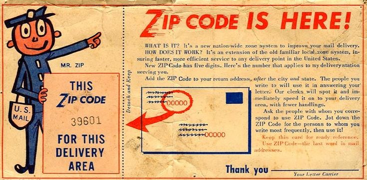 An easy form to fill out will ask you to enter the city, street name and house. And now, the treasured numbers are in front of you! All that’s left is to write it down!
An interesting fact: those organizations and individuals who receive huge volumes of correspondence are assigned individual indexes. The Finnish Joulupukki, for example, as well as the Canadian Santa Claus, have their own. By the way, you can write to the latter. He will definitely answer! And don’t forget the index – SANTA CLAUS!
If you notice a typo or inaccuracy on the site, select it |
Postal code is important!
How many people wonder what is a postal code and what is it for? This digital cipher is most often used automatically by most people when sending parcels and letters, when making numerous purchases on the Internet. Its importance is often only realized when a long-awaited package is lost due to a misspelled index or an important letter is delayed for too long.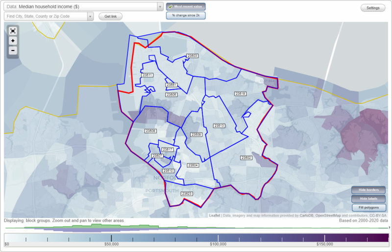
What is it and what is it for?
A postal code is a special combination of numbers established by the law of the Russian Federation, which is indicated on a letter, postcard, parcel or order form. It optimizes postal work: minimizing manual labor, increasing sorting efficiency, speeding up delivery, reducing the risk of errors when moving parcels and letters, and increasing the likelihood that the postal item will receive the correct addressee.
Indexes are written in special angular digits, this format is easier to read by computers. For the convenience of the sender, letters and letterheads are marked with patterns of writing numbers, as well as a form of thin dotted lines. Therefore, to fill in this column, special skills are not needed, accuracy and care are enough. It must be remembered that an error or lack of an index can lead to the loss of the shipment or its severe delay. Numbers can be written in ink of any color, except for green, red and yellow.
History
At all times people exchanged messages. Life sometimes depended on the speed and accuracy of information transfer. Beacons, swift-footed messengers, dogs, birds, passing caravans and ships were used. The Persians lined up thousands of people, placing them within earshot. With the help of roll call, messages were transmitted over long distances. Carrier pigeons with a phenomenal ability to find their home were especially accurate.
An evolutionary leap forward was the introduction of the telegraph in the first half of the 19th century. But he still could not cope with the information flow of rapidly developing humanity. Postal services could not cope with it either, they needed obvious improvements. The invention of the postal code helped to cope with the growing volume of letters and parcels. This elegant solution streamlined the work of mail, and eventually played a role in its automation.
Indexing in Russia
Postal indexing first appeared in the USSR in 1932.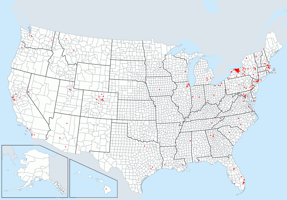 Experimental use of the index began in Soviet Ukraine and continued successfully until 1939, when the World War broke out. The indexes were canceled, apparently for national security reasons.
For the second time they began to be used throughout the entire Soviet Union. In 1971, a global indexation of the entire country was carried out. Numbers were assigned to each post office. Since then, on every parcel, greeting card or letter, the sender was required to indicate a digital index. This was done largely due to the fact that postal services began to use cutting-edge machines for processing items at that time.
How is it deciphered?
In the form in which the index is now used, it was approved in 1998. The postal division in our country corresponds to the administrative one. Today, the Russian postal code is a natural sequence of six digits, in the AAABBB format. AAA is a numerical code assigned to cities of republican, regional or regional significance. Large subjects of the federation and metropolitan areas have several codes.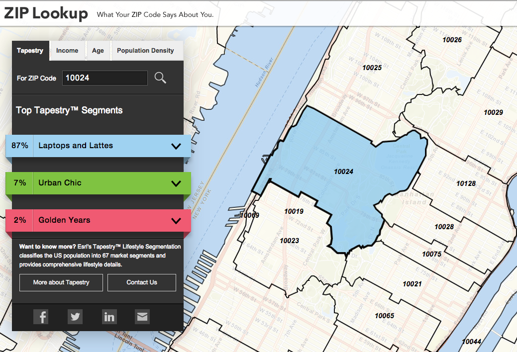 BBB is a numeric code that is assigned to each post office in a particular city.
For illustration. The following information is encrypted in the index 414042: 414 – Astrakhan city code, 042 – post office No. 42, which is located on Bumazhnikov Avenue and serves houses in the district. Other examples: 685007, 685 – code of Magadan, 007 – post office No. 7, serving houses on Ammonalnaya Street; 241027, 241 – code of Bryansk, 027 – post office serving buildings on K. Marx Square.
How can I find out the zip code?
In this age of the developed Internet, this is easy to do. There are three common ways to determine a postal code.
- First. Call or go to the post office. This method is suitable if you need to find out the index of a certain branch, which is located nearby. However, at the post office, employees will give information about any address, because they have the appropriate directories.
- Second. Use the help program. A convenient and detailed program is 2GIS.