Zip code plus 4 digit: Address Verification APIs
ZIP plus 4 plus 2 equals ZIP plus 6
Most of us know about ZIP+4 but to the average user of the United States Postal Service, ZIP+6 is unfamiliar. Join me, as we explore ZIP Codes, ZIP plus 4 and ZIP plus 6.
What is a ZIP Code?
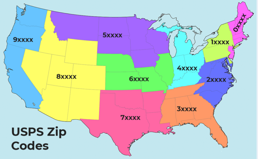
Although familiar to all of us in the U.S., the five-digit ZIP Code has only been around since 1963. ZIP Codes are numbered with the first digit representing a group of U.S. states, the second and third digits together representing a region in that group (or perhaps a large city), and the fourth and fifth digits representing a group of delivery addresses within that region.
What that boils down to, essentially, is that a single five-digit ZIP Code can represent a large number of actual addresses. So, 20 years later, the USPS introduced an expanded ZIP Code system that it called ZIP Plus 4.
What is ZIP Plus 4?
ZIP Plus 4 uses the basic five-digit code plus four additional digits to identify a geographic segment within the five-digit delivery area, such as a city block, a group of apartments, an individual high-volume receiver of mail or any other unit that could use an extra identifier to aid in efficient mail sorting and delivery.
The implementation of ZIP Plus 4 adds an extra level of precision that makes delivery easier, and very large organizations often have multiple ZIP Plus 4 codes assigned to the same address. One such example is California Polytechnic State University, in San Luis Obispo.
The street address for Cal Poly is 1 Grand Avenue, San Luis Obispo, CA 93407. Within the university, however, different departments or offices have their own ZIP Plus 4 Code. For example:
- Executive Assistant to President, 1 Grand Avenue, San Luis Obispo, CA 93407-0002
- University Police, 1 Grand Avenue, San Luis Obispo, CA 93407-0140
- Multicultural Engineering Program, 1 Grand Avenue, San Luis Obispo, CA 93407-0206
As a mail sender, chances are that all you’re going to put on the address is the five-digit ZIP Code and the mail will still reach it’s intended destination. So why bother with ZIP Plus 4?
What are the benefits of ZIP Plus 4?
If you’re sending large amounts of mail, using the ZIP+4 rather than just the five-digit ZIP Code can save you money. The caveat is that you need to use the right ZIP+4 – one that has been verified within the last 12 months.
Marketers can use ZIP+4 to better segment their target customers, because the granularity of ZIP+4 resolves down to a small handful of households. And the difference between households in different ZIP+4 Codes can be substantial. In some rural areas, for example, high-income neighborhoods with college-educated households and high employment can border low-income neighborhoods with high unemployment. If you’re marketing a luxury brand, guess where you’re better off sending your mailings?
But what if you want to achieve even tighter segmentation? What if you’re only interested in high-income households with two college-educated adults, no children, and a home value of over $500,000? As it happens, you’re in luck.
What is ZIP+4+2, or ZIP plus 6?
Where ZIP+4 takes you down to a few households, ZIP+6 takes you down to the actual delivery point. What do we mean by that? Let’s have an example…
The ZIP Code for the whole of Anytown is 12345. There’s a street with 40 houses called Mixed Drive. Addresses 1 through 20 have a ZIP+4 Code of 12345-6789, but houses numbered 8 through 16 are multi-family homes, each containing two households with the same street address.
Number 12, Mixed Drive is owned by the Moneybagges. They live in one side, and rent the other half to the Clampits.
Both the Moneybagges and the Clampits have the same ZIP Plus 4, so a segment containing that ZIP Plus 4 would include two very different demographics.
But the ZIP plus 6 is different for each household, and lets you separate the Moneybagges and the Clampits into different segments, along with other households with the same demographics. A much better option if you’re selling a high-value investment portfolio.
How do I find a ZIP Plus 6?
There are only a few address verification tools that can work down to ZIP Plus 6, and the fastest and most accurate is DataMatch Enterprise Address Verification.
With DataMatch Enterprise Address Verification, you can load thousands of addresses and standardize, verify and geocode to ZIP Plus 6 with ease. Being CASS™ and PAVE™ Gold certified to ensure the most accurate information across the board. It also works with the LACSLink® system to convert rural addresses to city style addresses to ensure delivery, and to stay updated with city-style addresses that may have changed or been renumbered.
If you need address verification down to the ZIP+4 or ZIP+6 level, contact us today to see the power of DataMatch Enterprise Address Verification.
latitude longitude – US ZIP Codes +4 By State or County- Shapefile (or table/dbf)
The ZipPlus4 information seems to be available in the (old) Tiger/Line 2000 data. e.g. ftp://ftp2.census.gov/geo/tiger/tgrcd108/FL/tgr12099.zip for Palm Beach County, FL.
According to gdal driver documentation,
Feature Representation Following is a list of feature types, and
their relationship to the TIGER/Line product.CompleteChain
A CompleteChain is a polyline with an associated TLID (TIGER/Line ID).
The CompleteChain features are established from a type 1 record
(Complete Chain Basic Data Record), and if available it’s associated
type 3 record (Complete Chain Geographic Entity Codes). As well, any
type 2 records (Complete Chain Shape Coordinates) available are used
to fill in intermediate shape points on the arc.…
ZipPlus4
These features are derived from type Z (ZIP+4 Codes) records.
ZipPlus4 features have a many to one relationship with CompleteChain
features.

However, the linked Tiger/Line 2000 data is in report type (.RT) files format, not in current GIS format.
Here are some example output for running ogrinfo TGR12099.RT1 ZipPlus4:
OGRFeature(ZipPlus4):50424
  MODULE (String) = TGR12099
  TLID (Integer) = 115356454
  RTSQ (Integer) = 0
  ZIP4L (Integer) = 3366
  ZIP4R (Integer) = 3367
OGRFeature(ZipPlus4):50425
  MODULE (String) = TGR12099
  TLID (Integer) = 115356457
  RTSQ (Integer) = 0
  ZIP4L (Integer) = 6048
  ZIP4R (Integer) = 6049
OGRFeature(ZipPlus4):50426
  MODULE (String) = TGR12099
  TLID (Integer) = 115356460
  RTSQ (Integer) = 0
  ZIP4L (Integer) = 2680
  ZIP4R (Integer) = 5151
OGRFeature(ZipPlus4):50427
  MODULE (String) = TGR12099
  TLID (Integer) = 115356485
  RTSQ (Integer) = 0
  ZIP4L (Integer) = 0
  ZIP4R (Integer) = 0
(Note: the TLID represents “complete chains” or arcs in the network). The complete chains are topologically correct according to the meta data:
- Complete chains must begin and end at nodes.
- Complete chains must connect to each other at nodes.
- Complete chains do not extend through nodes.
- Left and right GT-polygons are defined for each complete chain element and are consistent throughout the extract process.
There is an GIS.SE question
(Anyone who has the ESRI Census 2000 Tiger/Line data?), which has an answer describing a script for converting the .RT files to shapefiles. I haven’t tested it myself, but the code may be relevant.
Also, USPS really defines the ZIP(+4) codes etc. and may change it over time, so the Tiger/Line 2000 from census data may be outdated. Also, I am not an expert with Tiger data. You might want to check with the US Census/Tiger-line people to see if the ZipPlus4 is available in the current tiger-line files in GIS format.
Postcode 5: 09724 – APO, AE (Armed Forces)
You are here
home
»
All other territories and foreign countries
»
APO
Postal code 09724 is the postal code for APO, AE. In addition to the basic information, it also lists the full zip code and the address of the zip code 09724. Moreover, there is additional information related to the zip code 09724. For example, the nearest zip code is next to the zip code 09724, etc.
Postcode 09724 Main information
The main information of the postal index 09724 is as follows, including: country, district, city, FIPS, etc. Armed Forces
What is zip code plus 4 for zip code 09724? See below for details. nine0005
09724 ZIP+4 Code List
What are the 4 digit extensions of the zip code 09724? The zip code 09724 has many plus 4 codes, and each plus 4 code corresponds to one or more addresses. Below we list all +4 zip codes and their addresses in zip code 09724. You can find the 9 digit zip code by full address.
| Index 5 Plus 4 | Address |
|---|---|
| 09724-0001 | |
| 09724-0002 | PSC 81 BOX 100 (From 100 To 199), APO, AE |
| 09724-0003 | PSC 81 BOX 200 (From 200 To 299), APO, AE |
| 09724-0004 | PSC 81 BOX 300 (From 300 To 364), APO, AE |
| 09724-6001 | UNIT 36001, APO, AE |
| 09724-9998 | PSC 81, APO, AE |
How do I write a US envelope?
 org/Answer”>
First, you need to fill in the recipient’s postal information in the center of the envelope. The first line is the recipient’s name, the second line is the mailing address with detailed house number, and the last line is the city, state abbreviation, and zip code.
Second, write the sender’s information in the top left corner of the envelope. If your mail cannot be delivered, it will be returned to the sender’s address.
Finally, don’t forget to stick the stamp in the upper right corner. Otherwise, the letter will not go into the delivery process. nine0005
Here is an example of an envelope below.
What does each digit of the zip code 09724 mean?
The first digit denotes the national territory, which ranges from zero for the northeast to nine for the far west.
Numbers 2-3 indicate the object of the section center in this region.
The last two digits indicate small post offices or postal zones.

Random ZIP address 09724
Zip code 09724 has 9 real random addresses, you can click the picture below to get random addresses in zip code 09724.
Index 5: 09724 – APO
Comment
Zip Code: 47804, TERRE HAUTE, IN
ZIP Code 47804 is located in TERRE HAUTE, Indiana. Details of state, county, city, longitude, latitude, sample envelope, and population are provided below.
Postal Code 47804 Information
Country:
U.S. – United States
State:
IN – Indiana
County FIPS:
18167
County:
CountyFIPS: 18167 – VIGO
City:
TERRE HAUTE
Area Code:
812 / 930
City Type ?In many cases, a ZIP Code can have multiple “names”, meaning cities, towns, or subdivisions, in its boundaries. However, it will ALWAYS have exactly 1 “default” name.
D – Default – This is the “preferred” name – by the USPS – for a city. Each ZIP Code has one – and only one – “default” name. In most cases, this is what people who live in that area call the city as well.
A – Acceptable – This name can be used for mailing purposes. Often times alternative names are large neighborhoods or sections of the city/town. In some cases a ZIP Code may have several “acceptable” names which is used to group towns under one ZIP Code.
N – Not Acceptable – A “not acceptable” name is, in many cases, a nickname that residents give that location. According to the USPS, you should NOT send mail to that ZIP Code using the “not acceptable” name when mailing.:D (Default)
Postcode:
47804
❓What does D (Default) mean? This is the “preferred” name – USPS – for the city. Each zip code has one and only one “default” name. In most cases, this is what people living in the area also refer to as a city.
 Each ZIP Code has one – and only one – “default” name. In most cases, this is what people who live in that area call the city as well.
 Postal Code 47804 Plus 4
Postcode 5 plus 4 is an extension of the 5 digit postal code. It can be used to determine a more detailed location. The last four digits indicate a segment or one side of the street or an apartment. You can find the zip code +4 and the corresponding zip code address 47804 below. nine0005
Envelope example
This is an example of a US mail envelope. You can use a 5 digit zip code or a detailed 9 digit zip code to copy mail in the following address format.
47804 Basic value
What does each digit of zip code 47804 mean? The first digit denotes the national territory, which ranges from zero for the northeast to nine for the far west. 2-3 digits – this is the object code of the sectional center in this region. The last two digits indicate smaller post offices or postal zones. nine0005
Internet map
This is the address of TERRE HAUTE, Indiana, United States online map. You can use the button in the map to move, pantograph. This map information is for reference only.
hospital
This is the zip code 47804 – a list of hospital pages. His detailed hospital name, street, city, state, zip code, phone number are listed below.
| Name | Address | City |
|---|
