Aves de puerto rico fotos: aves autoctonas de Puerto Rico datos y fotos
:: Muscovy Duck (Pato Criollo) :: | :: White-cheeked Pintail (Pato Quijada Colorada) :: | :: Boba Parda (Brown Booby) :: | Brown Pelican (Pelicano Pardo) | :: Magnificent Frigatebird (Tijereta) :: |
:: Great Egret (Garza Real) :: | :: Flamenco (Flamingo) :: | :: Red-tailed Hawk (Guaraguao Colirrojo) :: | :: American Kestrel (Falcon Comun) :: | :: Wilson’s Plover (Chorlitejo piquigrueso) :: |
:: Killdeer (Chorlito Sabanero) :: | :: American Oystercatcher (Ostrero) :: | :: Black-necked Stilt (Viuda) :: | :: Greater Yellowlegs (Playero Guinella Mayor) :: | :: Willet (Playero Aliblanco) :: |
:: Lesser Yellowlegs (Playero Guinella Menor) :: | :: Laughing Gull (Gaviota Gallega) :: | Royal Tern (Charran Real) | White-winged Dove (Tortola Aliblanca) | Zenaida Dove (Trtola Cardosantera) |
:: Common Ground-Dove (Rolita) :: | :: Puerto Rican Lizard-Cuckoo (Pjaro Bobo Mayor) [ENDEMIC] :: | :: Smooth-billed (Ani Garrapatero) :: | :: Antillean Nighthawk (Querequeque) :: | :: Antillean Mango (Mango Antillano) :: |
:: Green Mango (Zumbador Verde) [ENDEMIC] :: | :: Antillean crested hummingbird (Zumbadorcito Crestado) :: | :: Puerto Rican Emerald (Zumbadorcito de Puerto Rico) [ENDEMIC] :: | :: Puerto Rican Tody (San Pedrito) [ENDEMIC] :: | :: Puerto Rican Woodpecker (Carpintero de Puerto Rico) [ENDEMIC] :: |
:: Puerto Rican flycatcher (Ju ) [ENDEMIC] :: | :: Gray Kingbird (Pitirre) :: | :: Lesser Antillean Pewee (Bobito) :: | Caribbean Martin (Golondrina de Iglesias) | :: Red-legged Thrush (Zorzal Patirrojo) :: |
:: Northern Mockingbird (Ruiseor) :: | :: Pearly-eyed Thrasher (Zorzal Pardo) :: | :: Yellow Warbler (Canario de Mangle) :: | Black-throated Blue Warbler (Reinita Azul) | Adelaide’s Warbler (Reinita Mariposera) [ENDEMIC] |
:: Elfin-woods Warbler (Reinita de Bosque Enano) [ENDEMIC] :: | :: Bananaquit (Reinita Comun) :: | :: Puerto Rican Tanager (Llorosa) [ENDEMIC] :: | :: Puerto Rican Spindalis (Reina Mora) [ENDEMIC] :: | Yellow-faced Grassquit (Gorrin Barba Amarilla) |
:: Black-faced Grassquit (Gorrin Negro) :: | :: Shiny Cowbird (Tordo Lustroso) :: | :: Greater Antillean Grackle (Mozambique) :: | :: Troupial (Turpial) :: | :: Antillean Euphonia (Jilguero) :: |
:: Orange Bishop (Obispo Anaranjado) :: | Scaly-breasted Munia (Gorrion Canela) | :: Pin-tailed Whydah (Viuda Colicinta) :: |
|
 youtube.com/embed/5YZFHU9dfR8″ frameborder=”0″ allow=”autoplay; encrypted-media” allowfullscreen=””> youtube.com/embed/5YZFHU9dfR8″ frameborder=”0″ allow=”autoplay; encrypted-media” allowfullscreen=””>
 youtube.com/embed/88ic_IBTCl8″ frameborder=”0″ allow=”autoplay; encrypted-media” allowfullscreen=””> youtube.com/embed/88ic_IBTCl8″ frameborder=”0″ allow=”autoplay; encrypted-media” allowfullscreen=””>
Otras Aves
Tomado de Documentos:
Vinda collicinat
ANIMALES
ANIMALES-(En
LOS MAMFEROS MARINOS
LAS DIEZ NUEVAS
PARA MAYOR INFORMACION
|
 Est
Est

 La espalda contiene gran cantidad de
 El perodo de encubacin es de 19
 El San Pedrito tiene un tamao aproximado de 8

 (9-10pulgs). Su peso promedio es de 54.6

 (4 pulgs). Su plumaje es negro
 Las
Las
 Pero las partes inferiores son


 dando origen a la celebre frase
 La pigmentacin
 Su dieta consiste

°HOTEL BOHO BEACH CLUB BOQUERON 2* (Puerto Rico) – from 12518 RUB
Very good1515 reviews10
Hotel Boho Beach Club – Boqueron
18. 0268031299825,
-67.168798148632
Bokeron,
Puerto Rico
12518RRUB
36 photo
36 photo
36 photo
36 photo
36 photo
address
Carr. 101 km 18.1,
Boqueron,
puerto rico,
00622,
Cabo Rojo Municipality
Show Map
Description
Featuring an outdoor pool, a nightclub and a golf course, Western Bay Boqueron Beach Hotel is a 2-star property offering air-conditioned rooms with city views. The center of Boqueron is 1 km away, while Paradise Scuba and Snorkeling Center is 4.6 km from the hotel.
Location
Near the hotel there is a train station and Poblado de Boqueron. This hotel is located a short distance from several noted attractions including Refugio de Vida Silvestre de Boqueron.
Rooms
Rooms at this hotel provide cable TV, free Wi-Fi and cable channels. Rooms come with private bathrooms.
Meals
Continental breakfast is served at the bar. The on-site restaurant serves Mexican cuisine. Restaurant “Los Roques Bar &” offers a wide range of dishes and is located about 100 meters from the hotel.
Internet
Free Wi-Fi is available in public areas.
Parking
Free private parking is available on site.
Number of rooms: 75.
Former name: western bay boqueron beach hotel
– Hide
Amenities
Most Popular Amenities
Free WiFi
parking
Luggage storage
24 hour service
Food/ Drinks
Restaurant
Swimming pool
Air conditioner
General
- Free Wi-Fi
- Parking lot
- Food/ Drinks
- Pool
- Lift
- Air conditioner
Food
- Restaurant
Leisure
- Pool
Amenities in the room
- Air conditioning
Media
- TV
- Telephone
Show all amenitiesHide list of amenities
Important Information
Check-infrom 15:00-23:59FREECheck-outuntil 12:00FREE
Extra bedsOne child0 – 12 yearsExisting bedsFREENo extra beds available in a room.
Pets Pets are not allowed.
+ More- Hide
Rooms & Availability
King Room
Beds to choose from:
King-size bed
Room size:
20 m²
Max:
2 guests
-
Shower
-
Air conditioner
Room Details
Queen Room
Beds to choose from:
2 king beds
Room size:
20 m²
Max:
2 guests
-
Balcony
-
Air conditioner
 org/LocationFeatureSpecification”>
Shower
Details of the number
Location
Carr. 101 km 18.1,
Boqueron,
puerto rico,
00622,
Cabo Rojo Municipality
- Famous places of the city
- Nearby
- Restaurants
Area
Poblado de Boqueron
1.2
km
Beach
National Park Balneario Bokeron
770 m
PR-10,0003
PuERTO RICO Adventure Water Sports
770 m
770 m
TANGA BEACH
TANGAA BEACH
Refugio de Vida Silvestre de Boqueron
1. 2
2
km
58 Calle Jose de Diego
Club Nautico Boqueron
1.2
km
Rte 101 Km 1.1
Refugio de Boqueron
1.2
km
Beach
Boqueron Beach
1.9
km
Bay
Bahia de Boqueron
2.4
km
Hwy 301 Km 1.1
Refugio de Vida Silvestre Iris L. Alameda Martinez de Boqueron
2.1
km
PR-301
Refugio de Aves
2.7
Km
Road 301 Km 11
Salt Flats and Wildlife Refuge
3.1
km
Cabo Rojo
Guaniquilla Tunnel
3.4
km
00623
Cueva Del Pirata Cofresi
3.6
km
Beach
Eden
3.6
km
Laguna Guaniquilla
3.6
km
Punta Guaniquilla
3.6
km
Islas Rocosas
3.6
km
Carr. 307 km. 4.8 int
Buje Beach
4.2
km
Guaniquilla
3.9km
Beach
Playa Bue
4.6
km
Paradise Scuba and Snorkeling Center
4. 6
6
km
Museum
Museo de los Proceres
6.2
km
Playa Bokeron
560 m
Restaurant
Pika-Pika Restaurant
80 m
Restaurant
World Cup Bar
260 m
Pelican’s Booquerón
0003
Reviews
7.0
Very Good15 reviews
FAQ
What airport is Western Bay Boqueron Beach Hotel located near?
Western Bay Boqueron Beach Hotel is located at a distance of 30 km from the airport Eugenio Maria de Ostos.
How far is Western Bay Boqueron Beach Hotel from the city center?
The distance between Western Bay Boqueron Beach Hotel and the city center is 1 km.
Are there restaurants near Western Bay Boqueron Beach Hotel?
Near Western Bay Boqueron Beach Hotel there is Los Roques Bar & Restaurant.
How much does it cost to stay at Western Bay Boqueron Beach Hotel?
A room at Western Bay Boqueron Beach Hotel starts from $204.
What rooms are available at Western Bay Boqueron Beach?
Western Bay Boqueron Beach offers you to choose between Queen Room and King Room.
Address
Carr. 101 km 18.1,
Boqueron,
puerto rico,
00622,
Cabo Rojo Municipality
Show map
Important information
Check-infrom 15:00-23:59FREECheck-outuntil 12:00FREE
Extra bedsOne child 0 – 12 years oldExisting beds are NOT FREEExisting beds are not available in a room.
Pets Pets are not allowed.
+ More- Hide
Transport
+ More- Hide
Need a transfer?
You can book your transfer after you have completed your booking at the hotel.
Tip: Consider free cancellation options. This will allow you to remain flexible should you need to cancel your trip due to the spread of COVID-19.
Thank you
nochi.com uses cookies that are strictly necessary for its functioning. We do not collect analytical and marketing cookies.OK
Which ocean does the Caribbean Sea belong to? Caribbean
CARIBBEAN SEA, a semi-enclosed marginal sea in the western part of the tropical zone of the Atlantic Ocean. In the west and south it is bounded by the mainland coasts of Central and South America, in the north and east by the ridge of the Greater Antilles (Cuba, Haiti, Puerto Rico) and the Windward Islands from the Lesser Antilles group. It is connected by the Yucatan Strait with the Gulf of Mexico, by numerous straits in the archipelagos of the Greater and Lesser Antilles – with the Atlantic Ocean, the Panama Canal – with the Pacific Ocean. The area is 2777 thousand km 2, the volume is 6745 thousand km 3. Maximum depth 7090 m (Caiman trench).
The coasts of Central America are low-lying, wooded, those of South America are mostly high, steep, with separate low areas covered with mangroves. Most of the islands have mountainous and steep coasts. The western and partially southwestern coasts of the sea are bordered by reefs. The main large bays are located in the western and southern parts of the sea: the Honduran, Mosquitos, Darien, Venezuelan Gulf with Lake Maracaibo, Paria. Of the large islands – Jamaica; many small islands, most of them in the western and southeastern parts of the sea.
The shelf is well expressed only off the coast of Honduras, Nicaragua and Venezuela (100-240 km), the continental slope is steep, on average about 17°, in some parts of the slope a steepness of up to 45° is noted. On the bottom strongly dissected by underwater ridges, deep basins stand out: Yucatan (4800 m), Colombian (4259 m), Venezuelan (5420 m), Grenada (4120 m). In the north of the Caribbean Sea, from west to east, along the southern foot of the underwater ridge of the same name, the Cayman Trench stretches. Most of the submarine ridges (Aves, Beata, Marcelino Sill, etc.) are apparently submerged island arcs. Bottom sediments are mainly represented by calcareous foraminiferal silts. Turbidity flows are an important factor in the formation of sediments for the flat relief of the basins; the most powerful precipitations were found in the north of the Venezuelan basin (up to 12 km).
The climate is maritime, warm, with little seasonal variability, determined by the location of the Caribbean Sea in the zone of trade wind circulation of the atmosphere. Average air temperatures in February are 24-27 °C, in August 27-30 °C. The amount of precipitation increases from east to west from 500 to 2000 mm per year. The largest average monthly precipitation falls in summer off the coast of Panama (up to 400 mm), the smallest – in winter off the coast of Cuba (about 20 mm).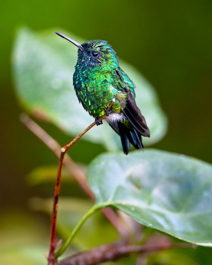 Northeast trade winds prevail over the sea with speeds of 5-7 m/s. Storm conditions are usually associated with tropical hurricanes, in which wind speeds reach 40-60 m/s. Hurricanes cross the Caribbean Sea in the western and northwestern directions at a speed of 10-20 km / h with an average frequency of 3 times a year (in some years more than 10).
Water exchange with the Atlantic Ocean is carried out mainly through deep straits: Windward, Sombrero, Dominica, etc.; with the Gulf of Mexico – through the Yucatan. Excitement is predominantly east and northeast, on average 3-4, rarely 5 points. The magnitude of annual level fluctuations is small and usually ranges from 8 to 30 cm. Short-term level fluctuations are observed during the passage of tropical hurricanes. The tides are irregular semi-diurnal, off the coast of Venezuela – irregular diurnal, magnitude up to 1 m.
The circulation of water is determined by the branches of the Antilles Current and the Guiana Current entering the Caribbean Sea through the northern and eastern interisland straits. These waters spread in a westerly direction called the Caribbean Current. In the eastern part of the sea, the current moves in two streams at a distance of 200-300 km from each other. At about 80° west longitude, both streams merge into one. The current velocity in the western part of the sea reaches 70 cm/s. Off the coasts of Cuba and Jamaica, the current forms several anticyclonic eddies; cyclonic eddies are observed along the coasts of Venezuela, Panama, and Costa Rica. The waters of the Caribbean Current through the Yucatan Strait are carried out into the Gulf of Mexico. In the strait, the highest speeds of surface currents from the mainland coast are up to 150 cm/s.
The surface water temperature varies throughout the year from 26°C in winter to 29°C in summer. Deep-water basins are filled with Atlantic waters with a temperature of about 4.3°C. The average salinity of water on the surface is from 35.5 to 36.5‰. By the end of the summer season, due to the abundance of precipitation and fresh river runoff, salinity decreases by 0. 5-1.0‰, its lowest values (33-34‰) near the islands of Trinidad and Tobago are explained by the large fresh runoff of the Orinoco River. The highest salinity of surface waters is in a narrow strip off the coast of South America and the coasts of Haiti and Cuba (over 36‰).
There are about 800 species of fish in the Caribbean, more than half of which are edible. Of the commercial fish, the most important are representatives of the families of snappers, serranids, crucians, several types of mullets, slabs, as well as sardinella, horse mackerel, mackerel, tarpon, anchovies. Fish of the open ocean are widespread – tuna, marlin, sailboats, common dormice, sharks.
The Caribbean coast is known for its beautiful beaches, it is the largest recreational area with numerous resorts. Lively shipping; passes the sea route through the Panama Canal, connecting the Atlantic and Pacific Oceans. Main ports: Santiago de Cuba (Cuba), Santo Domingo (Dominican Republic), Maracaibo (Venezuela), Barranquilla and Cartagena (Colombia), Colon (Panama).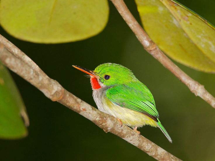
Lit.: Zalogin B. S., Kosarev A. N. Morya. M., 1999.M.G. Deev.
Caribbean Sea Tropical sea included in the Atlantic Ocean basin.
The Caribbean Sea, located between the two Americas, has a long history. Here, luxurious nature and excellent conditions for the development of tourism.
Origin
Science has not exactly determined the ancient age of the sea. It is believed that it began with a small reservoir, which in the Cretaceous period acquired the features of the modern sea.
The rising waters connected it to the Atlantic Ocean. It received its modern name from the Caribs, who displaced after the first millennium AD. Indians of the Antilles. Therefore, the Europeans, who discovered the sea in the middle of the last millennium, named it after this people.
Historical events
In the Middle Ages, the first Spanish settlement was founded in what is now Haiti.
Then Cuba and Hispaniola were conquered. The local Indians became slaves.
Later, Mexico was conquered and colonized. The British appeared
French, Dutch and Danish colonies. Mining was organized
gold and silver, the production of dyes, tobacco and sugar. For this from
Africa brought slaves.
Caribbean. about Haiti photo
Active trade with the mother countries caused
XVII century the emergence of piracy, which reached its peak in 1700-1730
years. Pirates hunted in this sea until the beginning of the 19th century. From now on
the process of decolonization begins, which ended in the twentieth century. On site
colonies formed independent states.
Dominant role in
the region began to play the United States.
At the beginning of the 21st century, the Association of Caribbean States recognized the sea as
a common heritage and a priceless asset that defines cooperation in
tourism, trade, transport and the fight against natural disasters.
Currents
The sea is characterized by several currents. So, from the southeast, currents drive cold water to the northwest at depths from 500 to 3000 m. Warmer subtropical currents go from above and continue to move, created by winds in a westerly direction.
Bypassing the coast of Central America, these waters enter the bay near the Mexican coast, raising its level above the Atlantic Ocean.
It is characteristic that if it usually flows at a speed of up to 2.8 km/h, then at the entrance to the strait near the Yucatan Peninsula it reaches 6 km/h.
The result is a pressure called hydrostatic. It is believed that it is he who makes the Gulf Stream move. From the south side of the sea, for almost a whole year, there is a circular rotation of water.
Which rivers flow into
The largest river in the region is the Columbian Magdalena, 1,500 kilometers long. In the same country, Atrato, Leon and Turbo flow into the sea. The Dike, Sinu, Catatumbo and Chama rivers flow into Lake Maracaibo connected to the sea.
Several rivers (Belen, Krikamola, Teribe, etc.) flow into the sea from the North American continent. Through Nicaragua, the Bambana, Indio, Coco, Kurinuas, Kukalaya, Prinsapolka, Rio Escondido and others flow into the sea.
From the territories of Honduras, Guatemala and Belize, the sea receives the waters of ten rivers of these countries. Rivers flow on the largest islands of the sea:
in Haiti – Yaque del Sur and Artibonite;
in Cuba, Cauto and Sasa;
in Jamaica, Milk River and Black River.
Relief
There are several significant depths in the sea, called basins, ranging in depth from 4120 to 7680 m.
Among them:
- Venezuelan (5420m)
- Grenadian (4120m)
- Kaimanova (7090m)
- Columbian (4532m)
- Yucatan (5055m)
They are separated by underwater ridges and straits. The highest of these ranges is off the coast of Venezuela. From its top to the surface of the sea over 2100 m. Straits have a depth of more than one and a half kilometers. In the eastern part of the sea within there is a deep-water passage Anegada, reaching a depth of 2350 m.
corals of the Caribbean Sea photo
Deep-sea bottom of the Caribbean Sea – calcareous or low manganese silt. In shallow water, sand or coral thickets.
Cities
There are dozens of cities on the North American and South American coasts and islands. Most of them have a long history associated with colonization. Thus, the Colombian port of Cartagena, conveniently located at the exit from the Gulf of Darien, was one of the key ports of the sea. It retained this meaning to this day.
Havana photo
Venezuelan Cumana was a stronghold of the Spanish colonizers who explored the mainland.
Founded in 1511, Havana turned from a once small settlement into a powerful fortress. Today it is the capital of the Republic of Cuba.
Santo Domingo photo
Today’s capital of the Dominican Republic, Santo Domingo had the status of the most beautiful city in the New World. Today it is one of the centers of Caribbean tourism. Modern port cities have become Costa Rican Lemon, Colombian Barranquilla, Maracaibo in Venezuela, Port-au-Prince in Haiti, Cienfuegos in Cuba. Many coastal cities are centers of tourism.
Flora and fauna
The rich and diverse animal world is represented here by hundreds of species of fish and birds, and many mammals. There are only four species of local sharks, which include:
bull sharks
tiger sharks
silky sharks
sharks living in Caribbean reefs.
shark in the Caribbean Sea photo
There are such fish as:
flying fish
and angel fish
sea Devil,
parrot fish
and butterfly fish
tarpon,
moray eel.
Commercial marine animals are sardines, lobsters and tuna. Divers and fishermen are attracted by marlins and barracudas.
Among mammals, dolphins, sperm whales, humpback whales, as well as manatees, called American, and groups of seals live here. On the islands you can meet different crocodiles and turtles, rare species of amphibians.
underwater world of the Caribbean Sea photo
Of the 600 species of birds, many are not found elsewhere. Toucans, parrots and other land birds live in the forests. Above the water you can see phaetons and frigates.
Vegetation of the Caribbean Sea, mostly tropical, here you can see fields of underwater macroalgae, there are several dozen species of them. Near corals, the plant world is more diverse: sea rupee, tortoiseshell alassia, cymodocean algae. Coastal mangroves attract many marine life.
the beauty of the Caribbean Sea photo
Characteristics
The sea has an area of more than 2.7 million square meters. km, average depth 1225m, maximum depth 7686m. It washes the shores of such continental countries: Venezuela and Honduras, Colombia and Costa Rica, Mexico and Nicaragua, Panama
and Cuba, Haiti and Jamaica.
Fifty islands also include small island countries. The islands, called the Lesser Antilles, are located in the eastern part of the sea.
turtle in the Caribbean photo
The South Antilles are scattered along the South American coast. Several archipelagos and many small islands are located on the western side of the sea.
The salinity of the water is about 35 ppm.
Climate
The climate here is tropical with a significant amount of precipitation depending on the region and season. It is affected by the circulation of air currents, the average speed of which can reach 30 km per hour. And there are also winds with a speed of 120 km / h, which causes hurricanes and storms. Such cataclysms occur in the northern part of the sea. They can destroy houses, ruin crops, take people’s lives.
The average monthly temperature varies between 21-29degrees of heat. About 500mm falls in the east, about 2000mm in the west.
- the largest coral barrier reef in the northern hemisphere is off the coast of Belize
- one third of the sea’s reefs have been destroyed or are in serious danger as a result of human activities
- Diving and fishing, important for tourism, annually bring up to 4 billion dollars to the Caribbean countries
- Coffee, bananas, sugar, rum, bauxite, oil, nickel produced in the countries of the region are exported mainly to the USA and Canada
- on the islands of the sea the number of people employed in the tourism sector, the volume of investment in it is two times higher than the world average
Port Royal was the largest English colony and pirate capital in the region. In 1692, it was almost completely destroyed by an earthquake and tsunami.
 In 1692, it was almost completely destroyed by an earthquake and tsunami.
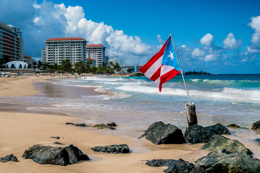
Jamaica, Cuba, Dominican Republic, Barbados, Puerto Rico – all these and many other well-known countries are located on the islands of the Caribbean and are known under the common historical name of the West Indies.
Surely, some tourists who want to relax in one of these countries have a question – where are the Caribbean Islands
? Washed by the waters of the Atlantic Ocean and the Caribbean Sea, they are located between North and South America. Discovered by Christopher Columbus in the 15th century, they number about seven thousand island land areas. There are 13 states on their territory. The Caribbean Sea washes not only the islands in it, but also the shores of South, Central and North America, so countries that have a Caribbean coast are also considered the Caribbean.
All the islands of the Caribbean are grouped into three large groups – the Bahamas, Lesser and Greater Antilles.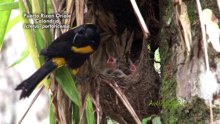 Each has its own geographical feature and, accordingly, relief. The Lesser Antilles, having an arched shape, stretch throughout the northern part of the archipelago. On their territory there are 8 Caribbean countries, among them – Barbados, Trinidad and Tobago, Dominica, Saint Lucia.
Greater Antilles is the place most visited by tourists. The territory of the Greater Antilles includes Cuba, Jamaica, Haiti, the Cayman Islands and Puerto Rico. These countries are loved by tourists because they have a mild tropical climate, a little humid. Evergreen forests, numerous rivers, endless beaches – all this is conducive to a good rest.
The Bahamas is a large archipelago with about 700 small islands in its territory. A large number of coral reefs, snow-white sands and coconut palms, tropical forests and the warm current of the Gulf Stream – all this cannot leave indifferent lovers of southern relaxation. In addition, for those who know where the Caribbean Islands are located and, accordingly, their origin, it is the Bahamas that reveals its underwater deep secrets. In addition to the fashionable resorts on the islands of Abaco and Eleuthera, the Bahamas are rich in nature, historical sites and friendly people.
The Caribbean is an oasis in the middle of the Atlantic Ocean. For outdoor enthusiasts, there are many geographical advantages here – from good wind conditions for sailing, to endless reef labyrinths with amazing underwater inhabitants. For a relaxing holiday – quiet sea lagoons framed by tropical forests make a vacation on the islands worthy of subsequent repetitions.
Caribbean Sea (Caribbean Sea) is located in the west of the Atlantic Ocean near the equator. With its tropical climate, numerous sandy beaches, crystal clear waters, renowned resorts and scenic spots, the Caribbean is a popular tourist destination. Cruise routes of well-known travel companies pass through the Caribbean region. The rich underwater world attracts thousands of diving enthusiasts. Mostly Caribbean resorts are visited by residents of the USA, Canada, Brazil.
Caribbean Islands Antilles and Bahamas include several large islands: Cuba, Haiti, Jamaica, Puerto Rico. Here are the Virgin Islands, the Cayman Islands.
The climate of the region is determined by the trade winds and the tropical region of the Atlantic Ocean. The average temperature during the year practically does not change and is +23 … +28 degrees. The Caribbean region is less affected by tropical hurricanes than the Gulf of Mexico and the Eastern Pacific
Flora and fauna The warm climate, coral reefs and clear water have created a rich underwater world of the sea. About 500 different species of fish live here, such as goliath fish, angel fish and parrot fish, moray eels and several types of sharks. There are whales, sperm whales and dolphins in the waters of the sea. The entire coastal area is covered with tropical forests with lush vegetation and a riot of colors
The Caribbean Sea region is a favorite vacation spot for many oligarchs from different countries.