Camuy puerto rico: Camuy | Discover Puerto Rico
Camuy, Puerto Rico
(kahm-WEE)
Camuy is known as “La Ciudad Romántica” (romantic city) and
“La Ciudad del Sol Taíno” (city of the Taino sun). The town was
founded in 1807, when it was disassociated from Arecibo by Petrolina Matos.
It is said that Camuy derives its name from a
word used by the Indians “camuy”, which means sun, at the same time
others think that it was the name that the Indians gave to the river that
crossed this region.
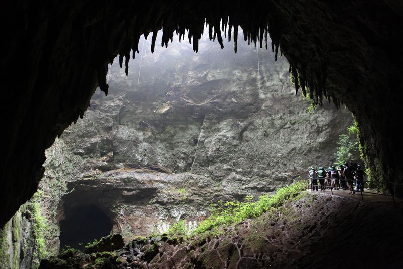
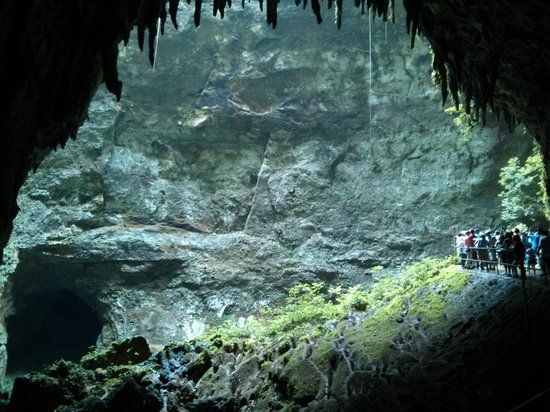
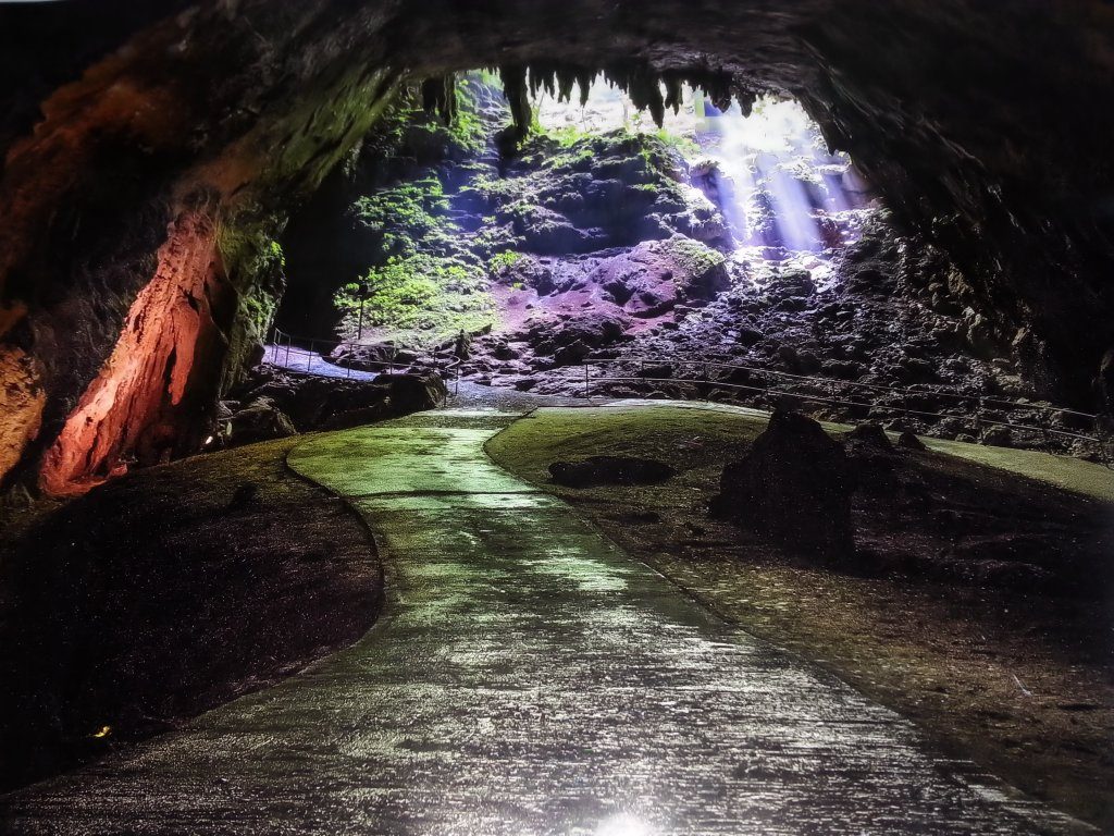
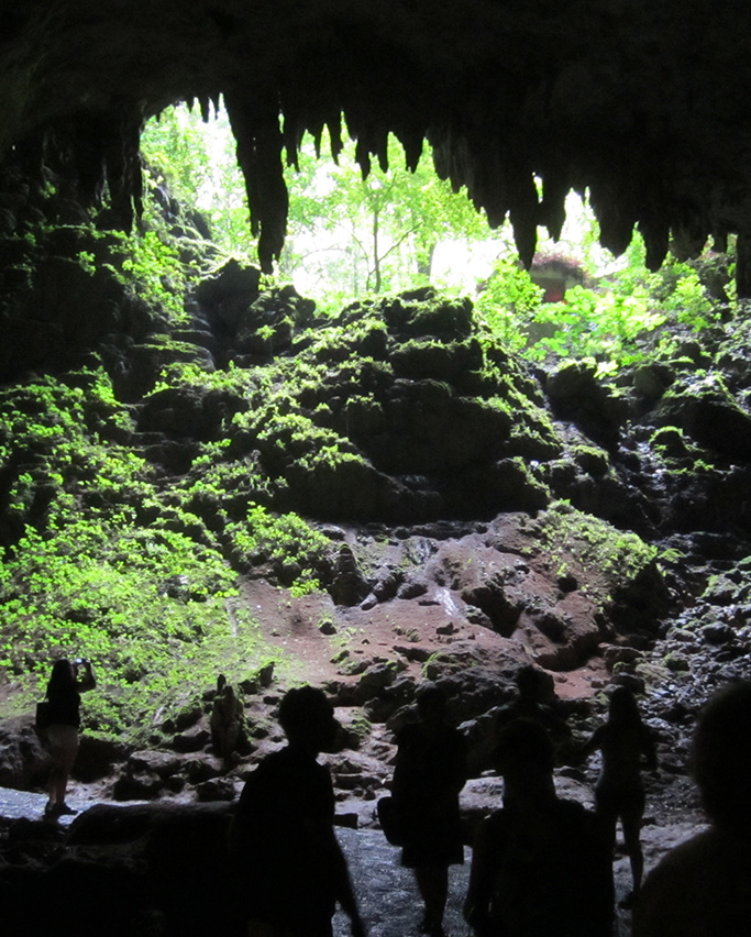
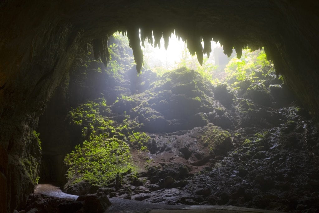
Rio Camuy Cave Park
If you take only one sightseeing trip from San Juan, this should be
it. From Arecibo, on the north shore, go southwest along Route 129 to the
Río Camuy Cave Park. This incredible 268-acre park is the site of
the great subterranean caverns carved out by the Camuy River over one
million years ago. The impeccably maintained trails gently descend 200
feet through a fern filled ravine to the yawning, cathedral-like caverns.
The caves are home to a unique species of fish that is totally blind.
To visit this pristine site is to be transported to another, hidden
world. Rio Camuy Cave Park is the third-largest cave system in the world.
Sixteen entranced have been found and 11 kilometers (7 miles) of passages
explored so far. One special attraction is the Cueva Clara, which
measures 695 feet (210m) in length.
The park is equipped with picnic
areas, walking trails, food facilities, and exhibition hall and a souvenir
shop, making it the perfect place to spend a day. Reservations are
essential, as this place is understandably popular. Open Wednesdays
through Sundays and holidays; 8am to 4pm. For information
call: (787) 898-3100 or (787) 763-0568.
If you are looking for an architecture delight, Iglesia La Piedra, also known as the Stone Church was
built in 1912 by locals with unworked limestone rocks. This unique small church was declared a historic monument by the
Puerto Rican Culture Institute in 1990.
Another place worth to mention is the Guajataca Lake, a reservoir created by the Puerto Rico
Electric Power Authority in 1929.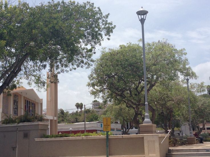 It supplies water San Sebastian, Camuy, Isabela and Quebradillas. The dam lies
across the Guajataca River to form the reservoir that can hold roughly 11 billion gallons of water. Located on Route 119, (787) 280-0430.
Additional Places and Sights
Other places worth exploring include:
- Hacienda Morell
- Paseo Tablado del Río Camuy (Boardwalk)
- Camuy History Museum
- Peñon Brussi Beach
Geography
Camuy territory is mostly flat because the city it is located on
the Valley of Quebradillas, bordering the Atlantic Ocean,
north of Lares; east of Quebradillas; and west of Hatillo. Its rivers are:
Cibao and Camuy.
Camuy is made up of 12 barrios (wards/districts):
- Abra Honda
- Camuy Arriba
- Ciénagas
- Cibao
- Membrillo
- Piedra
- Gorda
- Pueblo Puente
- Puertos
- Quebrada
- Santiago
- Yeguada
- Zanja
Climate
Camuy annual precipitation is 51 inches, and its average temperature is 78°F.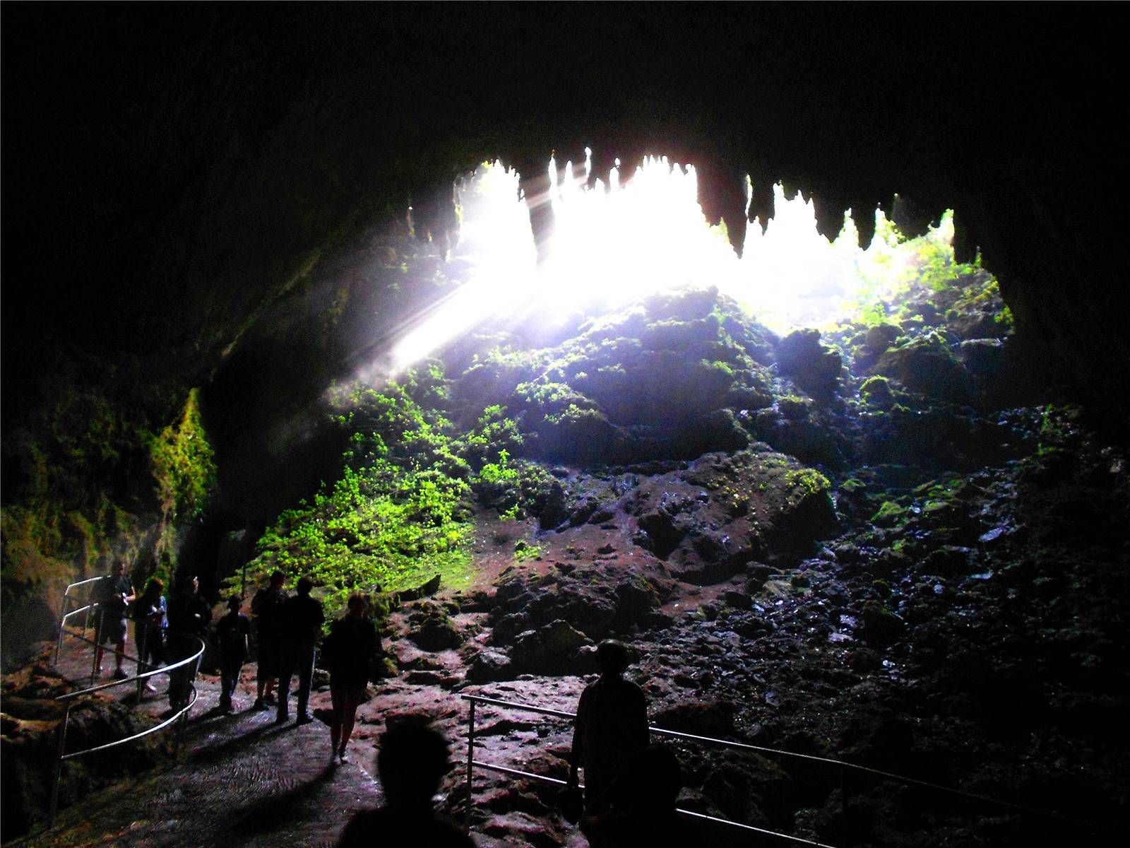
Precipitation is the lowest in March, with an average of 2.83 inches. Most precipitation falls in November, with an average of 5.9 inches.
July is the hottest month of the year, and February the coolest.
10-Day Forecast
Rio Camuy Cave Park
Restaurants
- Chilangos Mexican Grill (Mexican), (787) 262-4774
- El Fogon de Abuela (Puerto Rican), (787) 262-0781
- Palace China (Chinese), (787) 262-1392
- Sandwichera El Boricua (Deli/Sandwich), (787) 262-0576
Festivals and Events
- Carnaval Camuyano – February
- Feria de la Cultura – September
- Festival Playero Pena Brusi – July
- Fiestas Patronales de San Jose – May
Every year, Camuy celebrates a patron saint festival. The festivities include dances, food, parades and religious processions.
(787) 898-2160 - Velorio de los Reyes – January
Symbols
Demographics *
Population
32,827
Puerto Rico: 3,285,874
Land Area: 46.35 sq mi
Density: 670.2 per sq mi
Median Age: 43.3
Sex: 52% female
Economics **
Per capita income
$11,339
Puerto Rico: $21,058
Median household income: $18,571
Puerto Rico: $21,058
Persons below poverty line: 45.6%
Housing, families and educational attainment *
Number of households
11,349
Housing units density:
311.3 (2013)
Persons per household: 2.73
High school grad or higher: 72.5%
Marital status: 47% married
* U.S. Census Bureau 2020 data, unless otherwise noted – Source: Quick Facts Puerto Rico.
** U.S. Census Bureau 2016-2020
Map References
Coordinates: 18.4839° N, 66.8450° W
Zip Code: 627
Driving Distance from San Juan: 63.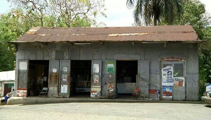 1 miles
Driving Time: 1 hour, 30 minutes
Camuy – Travel guide at Wikivoyage
Camuy – Romantic City – is a city east of Aguadilla and west of Arecibo on Puerto Rico’s north coast.
- San Juan: Luis Muñoz Marín International Airport
- Aguadilla: Rafael Hernández Airport
- Ponce: Mercedita Airport
By car[edit]
From Luis Muñoz Marín Airport near San Juan, take PR-2 west. The ride is about 90 minutes long.
Get around[edit]
Map of Camuy
- 18.484597-66.8466321 Camuy Pueblo (downtown Camuy). See the historic Roman Catholic church, Spanish-style recreational plaza, and the municipal buildings surrounded by streets and shops.
You can drive around the pueblo or park your car and walk around the square and into the plaza. The Spanish law, which regulated life in Puerto Rico in the early 19th century, stated the plaza’s purpose was for celebrations and festivities. (updated Apr 2022) - 18.325556-66.8380562 Camuy Caverns (Parque Nacional de las Cavernas del Río Camuy) (the main entrance to the park is in Quebrada). Part of a large network of natural limestone caves and underground waterways carved out by the third-largest underground river in the worPd, the Río Camuy (Camuy River)
- Camuy River Boardwalk
- Camuy City Square
- Manuel Canelas Museum
- Old Camuyan Casino
- Stone Church “Iglesia de Piedra”
 (updated Apr 2022)
- Los Amadores Beach
- Peñón Brussi Public Beach
” La Balseada del Río Camuy” (participants travel down river on makeshift crafts.) Annual event celebrated during spring.
” El Mondongazo” traditional food and “mondongo” (cow tripe cooked puertorican stile) are offered during this weekend festival at the end of summer (yearly event)
” El Velorio De Los Reyes” this festivity takes place every 5th of January to celebrate “Three Kings Day” at the town ‘s main square.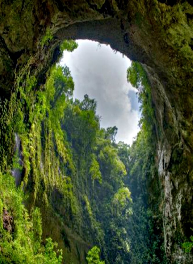 Enjoy traditional music. Kiosks around the square offer food and drinks. Local artisans offer their renditions of the “Three Kings” made out of native woods.
There are stores along the streets of the city center. Another shopping experience can be found in Plaza del Norte in Hatillo.
- Lune Du Soleil Spa & Wellness Center This full service spa located on Rt # 2 offers massages, skin, hair and nail care. Their service is as good as any other place found in the big cities. The prices are reasonable and the staff speaks English.
There are many places along Rt#2 to enjoy traditional puertorican food, international food or sea food with local flair. Many people speak English and will be glad to give you directions. Try “El Fogon de Abuela” by the shore close to Penon Amador Beach.
You can try Iguana’s Bar & Grill on Rt #2. Travel farther west (also on RT #2) to nearby Parador Guajataca in Quebradillas for Karaoke Night on weekends.
You can stay in “La Rosa del Mar” Hotel or “Punta Maracayo Resort” in nearby Hatillo (10 minutes east of Camuy by Rt #2).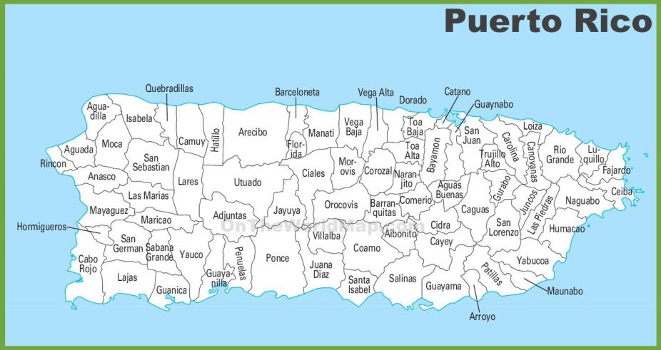 Both places are new (built after 2000) and offer good accommodations at a good price.
Go next[edit]
| This city travel guide to Camuy is an outline and needs more content. It has a template, but there is not enough information present. Please plunge forward and help it grow! |
Camui on the map, Puerto Rico. Exact time, nearest cities
Content
- Location
- Coordinates
- Population
- Local time
- Sunrise and sunset
- Surrounding cities
- Distance to the capital
Where is Camui located
The exact location is Camui, Camui, Puerto Rico, marked with a red marker on the map.
Coordinates
Camui, Puerto Rico coordinates in decimal format: latitude – 18.483833, longitude -66.8448994. When converted to degrees, minutes, seconds, Kamui has the following coordinates: 18°29′1. 8 north latitude and -66°50′41.64 east longitude.
Population
Camui, Camui, Puerto Rico, according to our records the population is – 4,240 inhabitants, which is approximately 0.1% of the total population of the country (Puerto Rico).
Comparison of the population on the graph:
Exact time
The time zone for this location Kamui is UTC -4 America/Puerto_Rico. The exact time is Wednesday, November 11, 2022, 09:51.
Sunrise and sunset
Kamui, sunrise and sunset data for the date – Wednesday 11/23/2022.
| Voskhod | Sunset | Day (duration) |
|---|---|---|
| 06:41 +1 minute | 17:46 -0 minutes | 11 hours 6 minutes. -1 minute |
You can control the scale of the map using the auxiliary tools to find out exactly where Kamui is located. When you change the scale of the map, the width of the ruler (in kilometers and miles) also changes.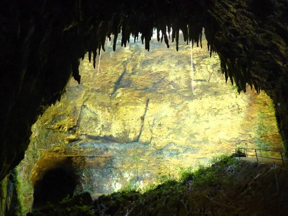
Nearest cities
Largest cities nearby:
- Ponce – 58 km
- Bayamon (United States) – 70 km
- Bayamon – 72 km
- Carolina – 94 km
- Punta Cana (Dominican Republic) – 164 km
- La Romana (Dominican Republic) – 223 km
- San Pedro de Macoris (Dominican Republic) – 257 km
- Santo Domingo (Dominican Republic) – 326 km
- San Cristobal (Dominican Republic) – 342 km
- San Francisco de Macoris (Dominican Republic) – 367 km
- La Vega (Dominican Republic) – 393 km
- Santiago (Dominican Republic) – 416 km
- Puerto Plata (Dominican Republic) – 425 km
- Cap-Haitien (Haiti) – 575 km
- Port-au-Prince (Haiti) – 575 km
- Carrefour (Haiti) – 583 km
- Leogane (Haiti) – 606 km
- Punto Fijo (Venezuela) – 831 km
- Coro (Venezuela) – 842 km
Distance to neighboring capitals:
- St. Thomas (US Virgin Islands) – 200 km
- Road Town (British Virgin Islands) – 234 km
- Santo Domingo (Dominican Republic) – 328 km
- Port-au-Prince (Haiti) – 575 km
– Juan) is approximately – 78 km.
 The 10 best hotels near
Rio Camui Cave Park in Atillo, Puerto Rico
Enter your dates and choose from 88 hotels and accommodations
Please enter a direction.
+
Check-in
+
Departure
Number of rooms and guests
2 adults
·
without children
·
1 number
I travel for work
Number of stars
5 stars
4 stars
3 stars
2 stars
1 star
Review score
Excellent: 9+
Very good: 8+
Good: 7+
Fairly good: 6+
Our recommendations
Lowest price at the beginning
Number of stars and price
Rating + number of reviews
Hotel Hacienda Agroturistico Vista Hermosa
 org/PostalAddress”>
Hotel in Camuy
(0.7 miles from Rio Camui Cave Park)
Hacienda Agroturistico Vista Hermosa is located in Camui. It offers a shared lounge, a garden and a terrace. Private parking is available at an additional cost.
Expand
Collapse
7.8
Good
79 reviews
Price from
€ 127
per night
Check Availability
Cavernas Guest House
Quebrada (0.8 miles from Rio Camui Cave Park)
Offering a restaurant, Cavernas Guest House is located in Quebrada. It offers free Wi-Fi and free private parking.
Expand
Collapse
8.6
Fantastic
5 reviews
Price from
€87
per night
Check Availability
Apartment Utuado
Utuado (15.8 miles from Rio Camui Cave Park)
Located in Utuado in the Puerto Rico Central region, Utuado has a balcony and river views.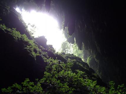 This apartment is 44 km from Ponce.
Expand
Collapse
9.6
Superb
13 reviews
Price from
€166
per night
Check Availability
Casa de Campo Rio Arriba
Arecibo (16.7 km from Rio Camui Cave Park)
Situated in Arecibo in the North Puerto Rico region, Casa de Campo Rio Arriba features a balcony and garden views. The apartment is 41 km from Isabela.
Expand
Collapse
9.5
Superb
37 reviews
Price from
€160
per night
Check Availability
Jardin del Mar Guesthouse
Hatillo (15.5 km from Rio Camui Cave Park)
Jardin del Mar is set in Hatillo, less than 1 km from Sardinera Beach and 23 km from Arecibo Observatory. It offers air-conditioned rooms with a private bathroom.
Expand
Collapse
8.6
Fantastic
34 reviews
Price from
€102
per night
Check Availability
Family Guest House
Quebradillas (18.8 miles from Rio Camui Cave Park)
Featuring a garden and a terrace, this guest house is located in Keboradlas. All rooms have a kitchenette, a flat-screen TV with satellite channels and a private bathroom.
Expand
Collapse
9.7
Superb
61 reviews
Price from
€ 94
per night
Check Availability
See more properties near Rio Camui Cave Park
No. 1
Booked hotel near Rio Kamui Cave Park
8.1
Very well
345 reviews
No. 2
Booked hotel near Rio Camui Cave Park
8.1
Very well
1,123 reviews
No. 3
Booked hotel near Rio Kamui Cave Park
7. 7
7
Good
1,005 reviews
No. 4
Booked hotel near Rio Kamui Cave Park
6.9
Review score
392 reviews
No. 5
Booked hotel near Rio Kamui Cave Park
7.2
Good
1 853 reviews
No. 6
Booked hotel near Rio Kamui Cave Park
8.6
amazing
435 reviews
No. 7
Booked hotel near Rio Kamui Cave Park
9.2
Perfect
620 reviews
No. 8
Booked hotel near Rio Kamui Cave Park
9.1
Perfect
102 reviews
No. 9
Booked hotel near Rio Camui Cave Park
9.0
Perfect
118 reviews
No. 10
Booked hotel near Rio Kamui Cave Park
9.3
Perfect
100 reviews
Excellent location
Set in Isabela, within a few steps of Jobos Beach and 2.3 km of Montones Beach, Bella Surf Inn offers accommodation with a terrace and free WiFi as well as free private parking for guests who drive.
The place is excellent if you want to explore the surroundings and get to know better the coast of.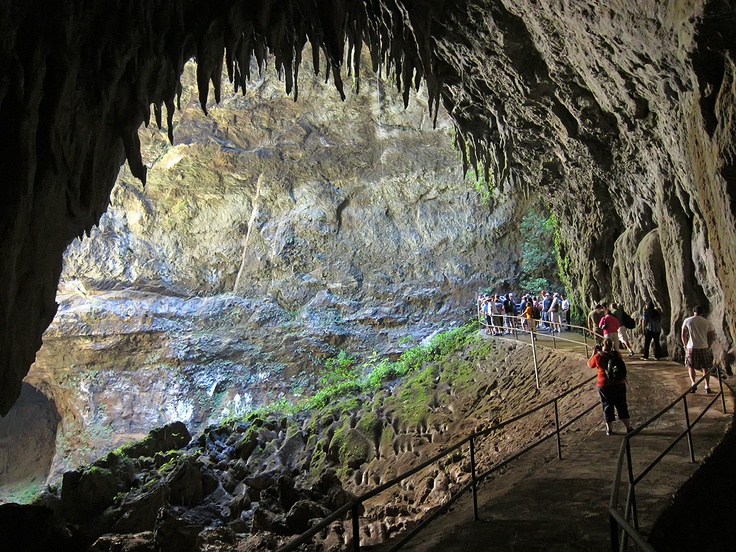 ..
..
Expand
Collapse
From € 113 per night
9.3
Perfect
100 reviews
Excellent location
Located in Utuado, Casa Grande Mountain Retreat has a restaurant, garden and terrace. Each hotel room has a balcony.
Casa Grande Mountain Retreat was fantastic, very special and peaceful place, the staff is great,…
Expand
Collapse
From € 169 per night
9.1
Perfect
102 reviews
Excellent location
The Royal Isabela is located in Puerto Rico’s Isabela, on the beautiful Caribbean coast. It offers spacious cottages with great sea views and free Wi-Fi.
Beautiful Views and great accommodations.
Expand
Collapse
From € 737 per night
9.1
Perfect
59 reviews
Excellent location
Featuring a garden, Hacienda Juanita is located in Maricao. It offers an outdoor pool, free Wi-Fi and free private parking.