Cidra puerto rico: Cidra | Discover Puerto Rico
Cidra
Cidra, Puerto Rico
Founded in 1809, Cidra is known as the «town of eternal spring» because of its cool temperatures. It is also known as the «town of the plain pigeon» because of the abundance of the endangered Puerto Rican plain pigeon (Columba inornata wetmorei), the only pigeon on the island that has blue eyes. This bird is larger than the common pigeon, has gray feathers and the wing coverts are edged in white. Its feet are reddish and its bill is black. It is often confused with the white-tipped dove, the white-winged dove and the zenaida dove.
Residents of Cidra, known as cidreños, numbered 42,753 persons, according to the 2000 U.S. Census. This municipality, located in the east-central region of the island, borders the municipalities of Comerio and Aguas Buenas on the north and Cayey on the south, Aibonito lies to the west and Caguas to the east. Cidra covers an area of 93.6 square kilometers (36.1 square miles). The territory is organized into thirteen sectors: Arenas, Bayamón, Beatriz, Ceiba, Cidra Pueblo, Honduras, Monte Llano, Rabanal, Rincón, Río Abajo, Salto, Sud and Toíta.
Geography
The municipality of Cidra is located on a plateau surrounded by mountains and streams in the northeast part of the island. Because of its location in the mountainous region, Cidra enjoys a subtropical climate with moderate temperatures.
The municipality’s terrain has been classified based on its slopes into categories of flat, semi-flat, moderate and steep. The steep terrain covers a total of 8,233 cuerdas while less steep areas cover 6,473 cuerdas. Another 2,708 cuerdas are considered flat or semi-flat, mostly along the length of La Plata River.
Elevations in the municipality range between 656 to 2,296 feet (200 and 700 meters). The highest points are the Almirante and Viento Caliente peaks 2,198 feet (669.950 meters), located in the Rabanal and Honduras sectors, and the Plana and Gordo peaks 2,165 feet (659.892 meters), which are located in the Honduras sector. The lowest point is near the Cidra dam.
The soil of Cidra originated as cretaceous rocks of volcanic and igneous formation and includes eight different groups and 12 series of soil.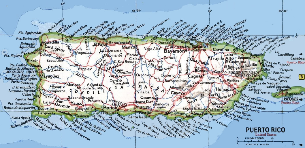
Cidra has four rivers, ten streams and a manmade lake. Its rivers are: La Plata, Clavijo, Bayamón, and Arroyata. The most important streams are Galindo, Caña, Bocana, Del Blanco, La Catalina, Ceiba, Pueblo Viejo, Solano, Prieta and Quebradillas. Lake Cidra is 300 cuerdas in size and has a capacity of 1.8 billion gallons of water. It supplies water to San Juan, Cataño, Río Piedras and other towns.
Growing citron (cidra, in Spanish) trees to sell the fruit for export was common in this region. From there came the municipality’s name, «Cidra Ridge.» Originally, it was a sector of the municipality of Cayey de Muesas.
Although there is no documentary proof, it is believed that a Catalan with the last name of Frujols built a chapel high in the mountains of Cidra around 1795, and within a few years a small hamlet had formed around it.
In 1807, a group of residents in the settlement and its surrounding areas authorized Victoriano de Rivera to ask the governor for authorization to found a town and an independent parish.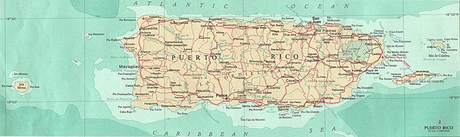
In 1809, Bibiana Vázquez, a landowner, donated the land needed for founding the town. After that, Governor Salvador Meléndez granted the residents’ petition. Meléndez designated Victoriano de Rivera to direct the town, but he fell ill shortly thereafter and was replaced by Wenceslao Vázquez.
By 1810, a wood church had been built and dedicated to San Juan Nepomuceno. It had a parish priest, a sacristan and a caretaker. On November 23, 1818, Cidra was elevated to the level of an independent parish. The same year, construction of the city hall began.
By 1822, Cidra had two private schools, but there were no public schools. Two years later, the Royal Road connected the town with Caguas.
In 1838, the municipality was organized into ten sectors: Arenas, Beatriz, Cidra Pueblo, Montellano (as it was written in that era), Rabanal, Río Abajo, Honduras, Rincón, Bayamón and Honduras. In 1868, the population surpassed 5,000 residents, including nearly two hundred immigrants from Spain, several French and Italians, and 195 slaves.
At the end of the 19th century, public education was still practically nonexistent. The government provided just one teacher for the entire zone. Because of the scarcity of schools on the island, more advanced students often taught the others.
Cidra residents have various popular legends about the horse that gallops in the night, about nocturnal horsemen who ride through the town, and the old woman who appears in the church or the old man at the entrance to the cemetery who asks for a ride and then disappears.
Popular personalities include don Nano with his coconut candies, doña Coca and her rice pasteles and don Vale with his coconut horchata.
Symbols
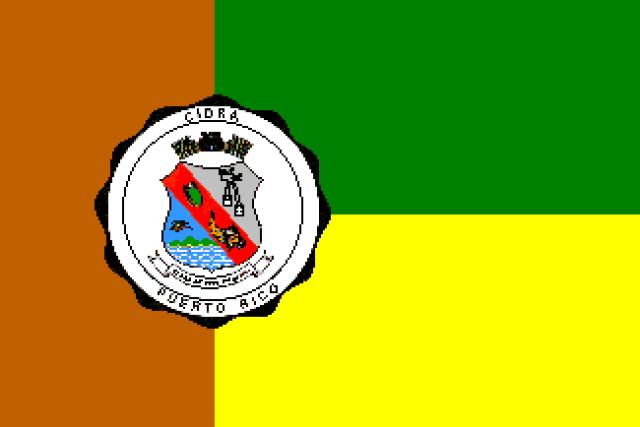
Flag
The flag has one vertical and two horizontal bands. The upper band is green, the lower is gold, and the vertical is brown. The green evokes the landscape that is spring-like throughout the year. The gold symbolizes the richness of the region’s fruits and waterways and the spirituality of the area and its residents. The brown alludes to the Virgin del Carmen, the patron saint of Cidra, and the Puerto Rican plain pigeon, a species found nowhere else in the world and that is most abundant in this municipality.
The municipal coat of arms appears on the flag where the three bands of color meet.
Coat of Arms
The coat of arms was created by J.J. Santa-Pinter. The red flag that cross the seal diagonally represents the name of the municipality and symbolizes the patriotism of the population and their daily struggles, as well as the martyrdom of Juan Nepomuceno, the original patron saint. A citron fruit and a gold cornucopia with fruits appear on the red band and allude to Cidra’s history as one of the largest fruit producers on the island.
In the upper right portion is a scapular that symbolizes devotion to the Virgin del Carmen, the town’s patron saint, and a black miter that represents Saint Juan Nepomuceno. In the lower left, on a blue background, is a plain pigeon flying over a mountain with three peaks, which indicates the geographic location of the municipality in the island’s central mountain range.
Places of Interest
• Ceiba Tree
• Lake Cidra
• Del Carmen Parish
• Las Hamacas Bridge
• Iberia Theater
Illustrious Citizens
Luis López Santos- athlete – baseball
Nicolás Ortiz Colón- writer
Víctor Serrano- writer)
Myrna Vázquez Díaz- actress
Pedro Vázquez Urbina- writer
Viviana Vázquez- granted land for the construction of the town of Cidra
Events
• Plains Pigeon Festival – November
• Patron Saint Festival – July
• Myrna Vázquez Díaz Week – February
Text taken from enciclopediapr.org
Video
Ayúdenos a describir todo lo que su municipio ofrece a las Industrías del Turismo y Negocios.
Favor enviar sus textos, fotografías y videos a:
Cidra, Puerto Rico Territory | Current Weather Forecasts, Live Radar Maps & News
Cidra, Puerto Rico Territory | Current Weather Forecasts, Live Radar Maps & News | WeatherBug
GroundTruth
- Sign In
- Press
- Education
- Feedback
- Careers
Settings
Locale ({{ $root.
 SelectedLocaleLanguage | uppercase }})
 SelectedLocaleLanguage | uppercase }})
 -
Now -
Hourly -
10 Day
Live Radar
Weather Details
Forecast
}
Featured Videos
Air Quality
Latest Weather News
Today’s National Outlook
Allergies & Pollen
Cold & Flu
Snow & Ski
Fire Center
Unavailable
Traffic Cameras
Weather Cameras
90,000 weather forecast for 3 days of cider, Puerto-rico
| Temperature, ° C | Atmospheric phenomena | are felt | UV-index | precipitation, mm | Dav.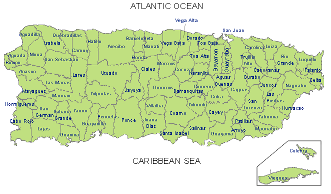 , mm , mm | moisture., % | Wind, m/s | Night | +16 +18 | Igated | +15 | 0 | 0.1 | 764 | 900 | 6.7 SSV | ||||||||||||
|---|---|---|---|---|---|---|---|---|---|---|---|---|---|---|---|---|---|---|---|---|---|---|---|---|---|---|---|---|
| Morning | +20 | Rain | 8 | 7.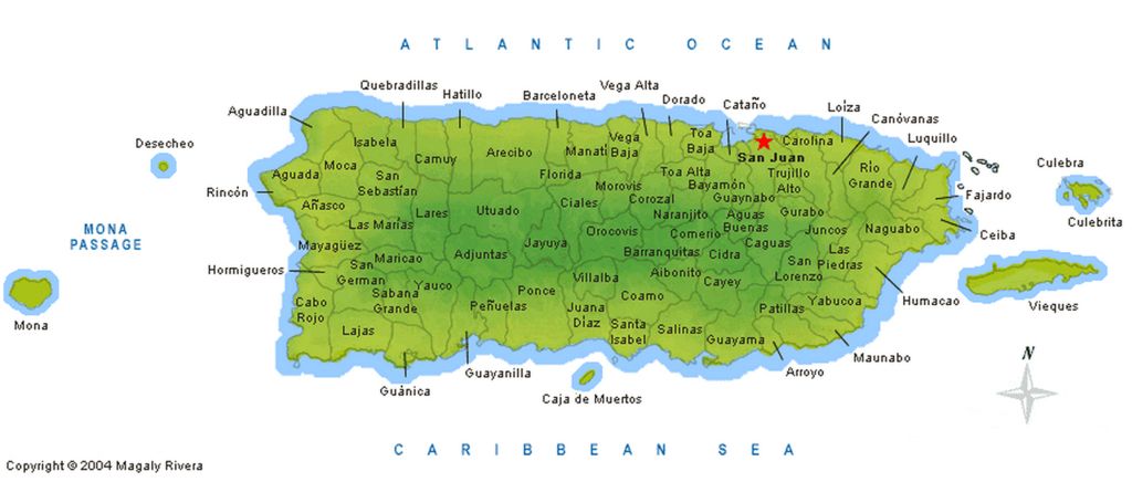 9 SV 9 SV | ||||||||||||||||||||||||
| Day | +21 +23 | Weak rain | +18 | 1.3 | 764 | 72 VSV VSV10 | moisture., % | wind, m/s | ||||||||||||||||||||
| Night | +16 +18 | +15 | 0 | 764 | 764 | 764 | 764 | 764 | 764 | 764 | 764 | 764 | 764 | 764 | 764 | 764 | 764 | 764 | 764 | 764 | 764 | 764 | 764 | 764 | 764 | 764 6.5 VSV | ||
| +18 +20 | +17 | 7 | 0 | 765 | 82 | 8.0 VVV0 9000 9000 9000 9000 9000 9000 9000 9000 9000 9000 9000 9000 | +21 +23 | Horm Rights | +19 | 9 | 0.7 | 764 | 69 | 8.1 VSV | +1 | +1 | +19003 +19003 +19003 +19003 +19031 +19003 +19003 +19003 +19003 +19003 +19003 +19003 +19003 +19003 +19003 +19003 +19003 +19003 +19003 +19003 +19AVER | +16 | 0 | 0 | 764 | 89 | 6.6 VSV | |||||
 Воздух прогреется до +19°C. Ветер восточно-северо-восточный, 8.0 м/с. Влажность воздуха 82%. Давление 765 мм”> Morning
030
Horoscope for the week
Sidra, Puerto Rico
On forecast
on our website you will always be able to find an accurate forecast for 3 days, long-term forecast for 10 days, long-term forecast for 10 days, long-term forecast for 10 days, long-term forecast for 10 days, long-term forecast for 10 days, long-term forecast for 10 days as well as a detailed hourly weather forecast. The accuracy of the weather forecast for 3 days is 80-90%. Data provided by NOAA, ECMWF, OpenWeatherMap. Any use of data from this site constitutes your full acceptance of the terms of the user agreement.
Sidra on the map, Puerto Rico. Exact time, nearest cities
Content
- Location
- Coordinates
- Population
- Local time
- Sunrise and sunset
- Surrounding cities
- Distance to the capital
Where is Sidra
The exact location is Sidra, Sidra, Puerto Rico, marked with a red marker on the map.
Coordinates
Sidra, Puerto Rico coordinates in decimal format: latitude – 18.1757914, longitude -66.1612779. When converted to degrees, minutes, seconds, Sidra has the following coordinates: 18°10′32.85 north latitude and -66°9′40.6 east longitude.
Population
Sidra, Sidra, Puerto Rico, according to our records the population is – 5,067 inhabitants, which is approximately 0.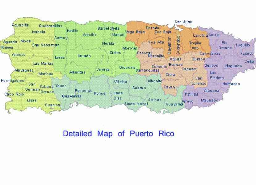 2% of the total population of the country (Puerto Rico).
Comparison of the population on the graph:
Exact time
The time zone for this location is UTC -4 America/Puerto_Rico. The exact time is Thursday, February 2, 2023, 03:49.
Sunrise and sunset
Sidra, sunrise and sunset data for the date – Thursday 02/09/2023.
| Voskhod | Sunset | Day (duration) |
|---|---|---|
| 06:57 -0 minutes | 18:20 +1 minute | 11 hours 24 minutes. +1 minute |
You can control the scale of the map using the auxiliary tools to find out exactly where Sidra is located. When you change the scale of the map, the width of the ruler (in kilometers and miles) also changes.
Nearest cities
Largest cities nearby:
- Bayamon (United States) – 20 km
- Bayamon – 21 km
- Carolina – 31 km
- Ponce – 51 km
- Punta Cana (Dominican Republic) – 239 km
- La Romana (Dominican Republic) – 296 km
- San Pedro de Macoris (Dominican Republic) – 331 km
- Santo Domingo (Dominican Republic) – 399 km
- San Cristobal (Dominican Republic) – 414 km
- San Francisco de Macoris (Dominican Republic) – 444 km
- La Vega (Dominican Republic) – 470 km
- Santiago (Dominican Republic) – 494 km
- Puerto Plata (Dominican Republic) – 503 km
- Port-au-Prince (Haiti) – 648 km
- Cap-Haitien (Haiti) – 652 km
- Carrefour (Haiti) – 656 km
- Leogane (Haiti) – 679 km
- Punto Fijo (Venezuela) – 837 km
- Coro (Venezuela) – 841 km
Distance to neighboring capitals:
- St.