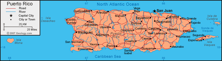
Puerto rico hidrografia: La hidrografía de puerto rico
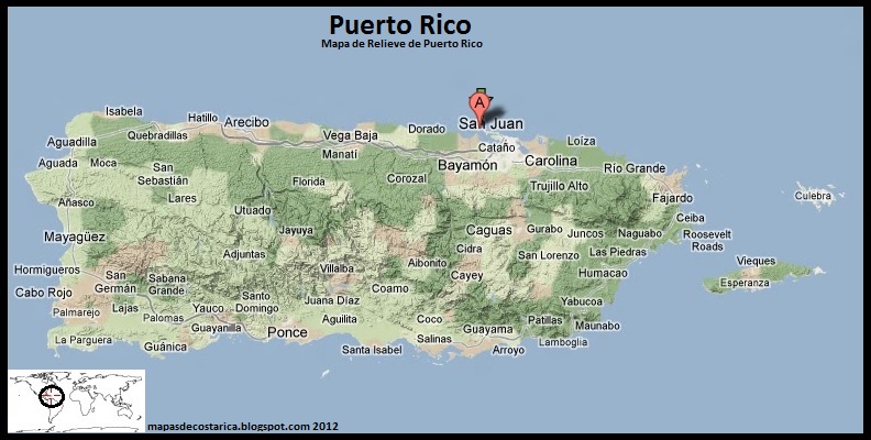
Pueblos de Puerto Rico – Hidrografía
Resumen hidrográfico de los ríos de Puerto Rico *
* Organizados geográficamente por su desembocadura
Los ríos de Puerto Rico se abastecen de las lluvias que caen sobre las Cordillera Central y las sierras de Luquillo y Cayey. Desembocan por los cuatro costados de la isla y visitan prácticamente todos los pueblos. Algunos de estos ríos llegan a sumirse en cavernas como es el caso del Río Camuy. Otros contribuyen al sistema lagos artificiales que suple agua potable a la población. Ningún río de Puerto Rico es navegable y actualmente no son explotados en la pesca comercial. Existen docenas de ríos y afluentes que se entrelazan por la isla pero aquí mencionaremos los mas relevantes a este trabajo.
A) RIO GUAJATACA – Nace en Lares y mide cerca de 25 millas de longitud. Este río fue muy apreciado por los indios tainos. Desemboca en el Océano Atlántico entre Aguadilla e Isabela.
B) RIO CAMUY – Se origina en las montañas de Lares y muere en el pueblo de Camuy. Corre por 30 kilómetros de los cuales viaja por debajo de la tierra en las Cavernas de Camuy. Este río cruza por los pueblos de Utuado, Lares, Hatillo y Camuy.
C) RIO GRANDE DE ARECIBO – El Río Grande de Arecibo es la unión del Río Vacas y el Río Cidra en el pueblo de Adjuntas. Corre por 33 millas hasta la Bahía de Arecibo. Este río pasa por los pueblos de Adjuntas, Utuado y Arecibo. El Río Grande de Arecibo participa del lago Adjuntas y el Lago Dos Bocas.
D) RIO GRANDE DE MANATI – Conocido entre los taínos como el Río Manatuabón. Nace en Barranquitas y corre por los pueblos de Barranquitas, Naranjito, Corozal, Morovis, Orocovis, Ciales, Barceloneta y Manatí. Su longitud es de 25 millas y muere por las costas de Manatí.
E) RIO CIBUCO – Se origina en Corozal y tiene una longitud de 22 millas. Fue famoso entre los Colónizadores por su explotación minera. Este río visita los pueblos de Corozal, Vega Alta y Vega Baja desembocando entre estos últimos dos pueblos.
F) RIO GRANDE DE LA PLATA – Este es el río más largo de Puerto Rico y su nombre en taino era Toa que significa madre. Nace en el Cerro La Santa de Cayey y corre por 60 millas. Desemboca en Dorado no sin antes pasar por Comerío, Toa Alta y Toa Baja. Los lagos Carite y La Plata pertenecen a este río.
G) RIO DE BAYAMON – Surge en el municipio de Cidra y corre por 25 millas. Este Río desemboca en la Bahía de San Juan y recorre por Cidra, Guaynabo, Toa Baja, Bayamón y Cataño. El Lago de Cidra y la Represa de San Juan son parte de este río.
H) RIO GRANDE DE LOIZA – Nace en la Sierra de Cayey y atraviesa 40 millas de longitud antes de morir en Loiza. Cruza San Lorenzo, Caguas, Gurabo, Trujillo Alto, Carolina, Canóvanas y Loíza Aldea. Parte de este río es el Lago Loíza (Carraizo) localizado entre los municipios de Trujillo Alto, Caguas y Gurabo.
I) RIO ESPIRITU SANTO – Nace en la Sierra de Luquillo y corre por 12 millas. Es uno de los ríos más hermosos de la isla y es parte de la reserva natural del Yunque.
J) RIO MAMEYES – Tiene su origen en la Reserva Forestal de Luquillo y se extiende por 10 millas. Cruza por los pueblos de Río Grande y Luquillo.
K) RIO FAJARDO – Nace en Ceiba y muere en Fajardo después de correr 15 millas. Desemboca en la sonda de Vieques.
L) RIO DAGUAO – Nace en la municipalidad de Ceiba y tiene una longitud aproximada de 7 millas. El Daguao desemboca entre los pueblos de Ceiba y Naguabo.
M) RIO BLANCO – Este río nace de la unión del Río Cubuy, el Río Icacos y el Río Prieto en la Reserva Forestal de Luquillo. Corre por 9 millas y desemboca en la municipalidad de Naguabo.
N) RIO HUMACAO – Nace el Río Humacao en la municipalidad de Las Piedras y recorre 16 millas antes de salir al mar por el municipio de Humacao.
O) RIO MAUNABO – El Río Maunabo le da nombre a este pueblo de la costa sureste y corre por los pueblos de Patillas y Maunabo. Su longitud estimada es de 10 millas
P) RIO COAMO y RIO DESCALABRADO – El Río Coamo nace en Coamo y corre por unas 19 millas hasta llegar a Santa Isabel.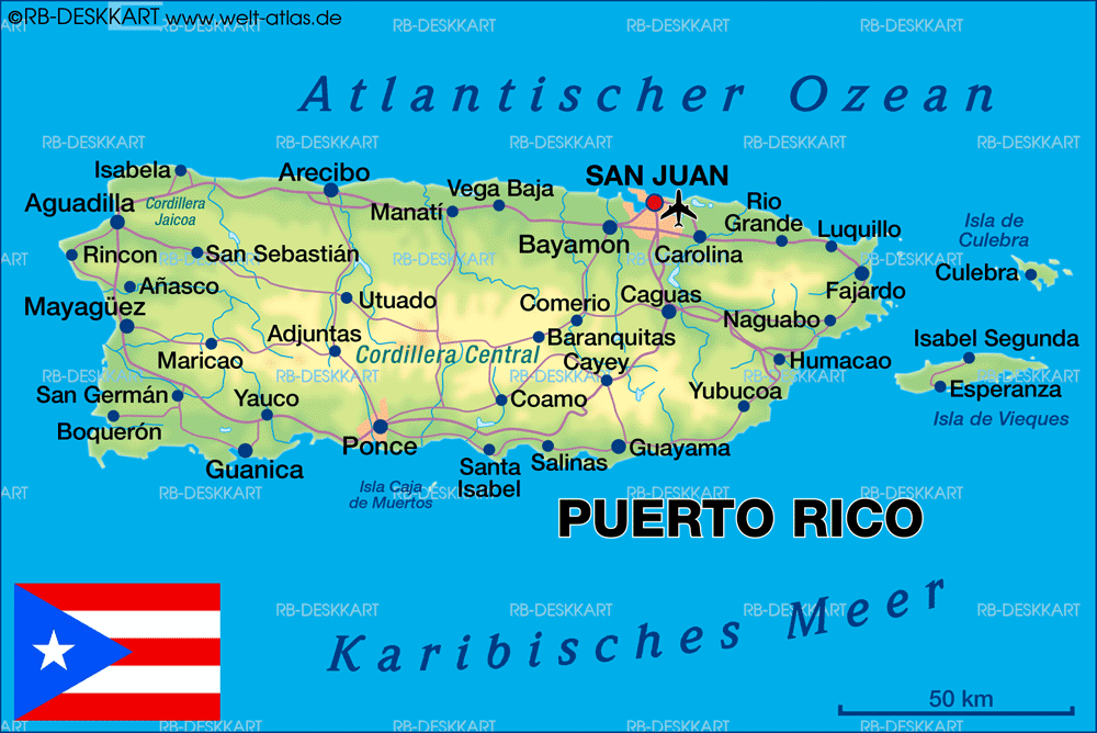 El Río Descalabrado nace en Coamo y corre por los pueblos de Coamo, Santa Isabel y Juana Díaz. Estos ríos tienen una longitud aproximada de15 y desembocan en el Mar Caribe.
Q) RIO CAÑAS, RIO JACAGUAS, RIO INABON y RIO BUCANA – Corren norte a sur con longitudes de 10 a 20 millas. Esta serie de ríos cruzan los pueblos de Juana Díaz, Villalba y Ponce.
R) RIO PORTUGUES, RIO MATILDE, RIO TALLABOA y RIO MACANA – Esta es una serie de ríos sureños que corren de norte a sur con longitudes menores a las veinte millas. En su trayecto visitan mayormente a los pueblos de Adjuntas, Ponce, Peñuelas y Guayanilla.
S) RIO GUAYANILLA, RIO YAUCO y RIO LOCO – Estos ríos del suroeste de la isla, nacen en la cordillera central y corren los pueblos de Yauco y Guayanilla. Estos eran los ríos principales del yucayeque de Guanía donde reinaba Agüeybaná el Grande.
T) RIO GUANAJIBO – Este río nace en la cordillera central y recorre 24 millas hasta el hasta llegar al Pasaje de Mona al oeste de Puerto Rico. En su trayecto pasa por los pueblos de Sabana Grande, San Germán, Hormigueros, Cabo Rojo y Mayagüez.
U) RIO YAGUEZ – El Río Yagüez nace en las montañas Urayoán entre Las Marías y Maricao. Tiene una longitud de 13 Millas y muere en el pueblo de Mayagüez. La represa de Mayagüez es parte de este río. Los mayagüezanos alegan que Cristóbal Colón desembarco en la boca del Yagüez cuando descubrió a Puerto Rico.
V) RIO GRANDE DE AÑASCO – Se origina de la unión de los ríos Blanco y Prieto en el municipio de Lares. Este río cruza por Adjuntas, Lares, Las Marías, San Sebastián, Añasco y Mayagüez. Su longitud aproximada es de 40 millas y desemboca por el Canal de la Mona.
Rios de Puerto Rico (hidrografía)
Map Quiz: Rios de Puerto Rico (hidrografía)
Educaplay uses its own and third-party cookies for anonymous analytical purposes, save the preferences you select, personalize the advertising you see based on your browsing habits and for the general operation of the page.
You can accept all cookies by clicking the “Accept” button or configure or reject their use by clicking the “Set up” button.
You can obtain more information and reconfigure your preferences at any time in the Cookies policy
If you are under 14 years old, ask your parent or guardian to read this message before continuing.
SCORM download
To be used in an LMS (Moodle, Blackboard…)
- SCORM 1.2
- SCORM 2004
Regular download
To be published on a website or blog.
The download of activities is an exclusive feature for Premium Academic users or higher.
Get your Premium license now and start inserting the Educaplay activities in your LMS, web or blog.
Get Premium Academic
If you wish, you can download a demo activity here and test its integration:
- Download SCORM 1.2 activity demo
- Download SCORM 2004 activity demo
- Download activity demo without SCORM
Duplicate this activity and share your own version to check the results of your players.
Share
copied
Insert
copied
You have exceeded the maximum number of activities that can be shared in Google Classroom for your account type.
If you want to continue inserting activities in Google Classroom, purchase a Premium Academic or higher account now and enjoy unlimited insertions.
Get Premium Academic
You have exceeded the maximum number of activities that can be shared in Microsoft Teams for your account type.
If you want to continue inserting activities in Microsoft Teams, purchase a Premium Academic or higher account now and enjoy unlimited insertions.
Get Premium Academic
1
00:34
time
100
score
2
00:57
time
100
score
3
Kari
03:16
time
100
score
4
00:35
time
90
score
5
Jo
00:44
time
80
score
6
00:46
time
60
score
Do you want to stay in the Top 10 of this activity? Log in to identify yourself.
Create your own free activity from our activity creator
Create map quiz
Compete against your friends to see who gets the best score in this activity
Create challenge
Ocean – Wikipedia
This term has other meanings, see Ocean (disambiguation).
Ocean (ancient Greek Ὠκεανός, on behalf of the ancient Greek deity Ocean) is the largest water body that forms part of the World Ocean, located among the continents, has a water circulation system and other specific features. The ocean is in constant interaction with the atmosphere and the earth’s crust.
Ocean division options
The surface area of the World Ocean, which includes oceans and seas, is about 71% of the Earth’s surface (about 361 million km²) [1] . The relief of the bottom of the oceans of the Earth as a whole is complex and diverse.
They also speak of oceans in relation to other planets and their satellites, for example, the ocean of Europa.
The science that studies the oceans is called oceanology; fauna and flora of the ocean is studied by a branch of biology called ocean biology.
Contents
- 1 Antique value
- 2 Modern definition of oceans
- 2.1 Overview of the oceans
- 3 Ocean formation
- 4 Bathymetric position
- 5 Ocean and atmosphere
- 6 Ocean and climate
- 7 Chemical composition
- 8 Flora and fauna
- 9 Extraterrestrial oceans
- 10 The ocean in literature
- 11 See also
- 12 Notes
- 13 Literature
- 14 Links
Ancient meaningEdit
In ancient Rome, the word Oceanus denoted the waters that washed the known world from the west, that is, the open Atlantic Ocean. In this case, expressions Oceanus Germanicus (“German Ocean”) or Oceanus Septentrionalis (“Northern Ocean”) denoted the North Sea, and Oceanus Britannicus (“British Ocean”) the English Channel.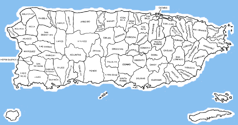
Modern definition of the oceansEdit
See also: Pacific Ocean, Atlantic Ocean, Indian Ocean, Arctic Ocean, Southern Ocean, and Oceanology
World Ocean – global volume of sea water, the main part of the hydrosphere, which is 94.1% of its entire area, a continuous, but not continuous water shell of the Earth, surrounding the continents and islands and characterized by a common salt composition. Continents and large archipelagos divide the world’s oceans into parts (oceans). Large regions of the oceans are known as seas, bays, straits, etc.
Some sources divided the World Ocean into four parts, others into five parts [2] . From 1937 to 1953, five oceans were distinguished: the Pacific, Atlantic, Indian, Arctic and Southern (or Southern Arctic) oceans. The term “Southern Ocean” appeared many times in the 18th century, when a systematic study of the region began. In the publications of the International Hydrographic Organization, the Southern Ocean was separated from the Atlantic, Indian and Pacific into 1937 year. There was a rationale for this: in its southern part, the boundaries between the three oceans are very arbitrary, at the same time, the waters adjacent to Antarctica have their own specifics, and are also united by the Antarctic circumpolar current. However, later the separation of a separate Southern Ocean was abandoned [3] . In 2000, the International Hydrographic Organization adopted a division into five oceans, but this decision has not yet been ratified and therefore only 4 oceans legally remain [4] .
| Ocean | Area, million km² | Volume, million km³ | Average depth, m | Maximum depth, m | Seas |
|---|---|---|---|---|---|
| Atlantic | 91.6 | 329.7 | 3600 | 8742 (Puerto Rico Trench) | Baltic, Northern, Mediterranean, Black, Sargasso, Caribbean, Adriatic, Azov, Balearic, Ionian, Irish, Marble, Tyrrhenian, Aegean; Bay of Biscay, Gulf of Guinea, Gulf of Mexico nine0106 |
| Indian | 73. 556 556 | 292.1 | 3890 | 7725 (Zonda Trench) | Andaman, Arabian, Red, Laccadive, Timorese; Bay of Bengal, Great Australian Bight, Persian Gulf |
| Arctic | 14.75 | 18.1 | 1225 | 5527 (in the Greenland Sea) | Norwegian, Barents, White, Kara, Laptev, East Siberian, Chukchi, Greenland, Beaufort, Baffin, Lincoln; Hudson Bay nine0106 |
| Quiet | 169.2 | 710 | 4280 | 11022 (Marian Trench) | Bering, Okhotsk, Japanese, East China, Yellow, South China, Javanese, Sulawesi, Sulu, Philippine, Arafura, Coral, Fiji, Tasmanovo |
| South | 20.327 | 72.37 | 3270 | 8264 (South Sandwich Trench) | Lazarev Sea, Riiser-Larsen Sea, Cosmonauts Sea, Commonwealth Sea, Davis Sea, Mawson Sea, D’Urville Sea, Catfish Sea, Ross Sea, Amundsen Sea, Bellingshausen Sea, Scotia Sea, Weddell Sea nine0106 |
Brief description of the oceansEdit
Pacific
Pacific Ocean (or Great ) is the largest ocean in terms of area and depth on Earth. It is located between the continents of Eurasia and Australia in the west, North and South America in the east, Antarctica in the south. In the north, through the Bering Strait, it communicates with the waters of the Arctic, and in the south – with the Atlantic and Indian Oceans. Occupying 49.5% of the surface of the World Ocean and containing 53% of the volume of water in the World Ocean, the Pacific Ocean extends approximately 15.8 thousand km from north to south and 195000 km from east to west. The international date line runs through the Pacific Ocean along the 180th meridian. The study and development of the Pacific Ocean began long before the appearance of a written history of mankind. Junks, catamarans and simple rafts were used to navigate the ocean. The expedition of 1947 on a raft of balsa logs “Kon-Tiki” under the leadership of the Norwegian Thor Heyerdahl proved the possibility of crossing the Pacific Ocean in a westerly direction from central South America to the islands of Polynesia.
 Chinese junks made trips along the ocean coast to the Indian Ocean (for example, Zheng He’s seven voyages in 1405-1433) [5] . At present, the coast and islands of the Pacific Ocean are developed and populated extremely unevenly. The largest centers of industrial development are the US coast (from the Los Angeles region to the San Francisco region), the coast of Japan and South Korea. The role of the ocean in the economic life of Australia and New Zealand is significant [6] .
Atlantic
Atlantic Ocean – the second largest ocean of the Earth after the Pacific Ocean, the name comes from the name of the titan Atlas (Atlanta) in Greek mythology or from the legendary island of Atlantis. It extends from subarctic latitudes all the way to Antarctica [7] . The border with the Indian Ocean runs along the meridian of Cape Agulhas (20°E to the coast of Antarctica (Dronning Maud Land) [8] .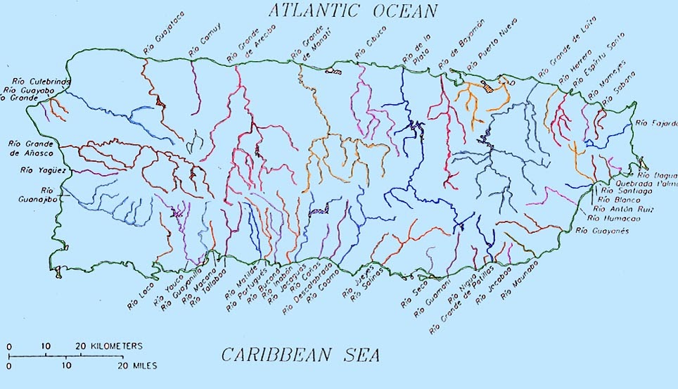 The border with the Pacific Ocean is drawn from Cape Horn along the meridian 68°04’W or along the shortest distance from South America to the Antarctic Peninsula through the Drake Passage, from Oste Island to Cape Sternek.The border with the Arctic Ocean passes through the eastern entrance of the Hudson Strait, then through the Davis Strait and along the coast of Greenland Island to Cape Brewster, through the Denmark Strait to Cape Reidinupur on the island of Iceland, along its coast to Cape Gerpir, then to the Faroe Islands, then to the Shetland Islands and along 61 ° north latitude to the coast of the Scandinavian Peninsula [9] . The area of the seas, bays and straits of the Atlantic Ocean is 14.69 million km² (16% of the total ocean area), the volume is 29.47 million km³ (8.9%). The area is 91.6 million km², of which about a quarter is inland seas. The area of coastal seas is small and does not exceed 1% of the total water area. The volume of water is 329.7 million km³, which is equal to 25% of the volume of the oceans.
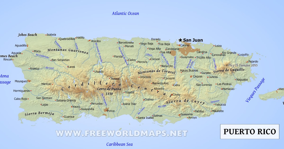 The average depth is 3736 m, the greatest is 8742 m (Puerto Rico Trench). The average annual salinity of the ocean waters is about 35 ‰. The Atlantic Ocean has a strongly indented coastline with a pronounced division into regional water areas: seas and bays.
nine0003
Indian Ocean
The Indian Ocean is the third largest ocean on Earth, covering about 20% of its water surface. The Indian Ocean is mainly located south of the Tropic of Cancer between Eurasia in the north, Africa in the west, Australia in the east and Antarctica in the south [7] . Its area is 76.17 million km², volume – 282.65 million km³. In the north it washes Asia, in the west – the Arabian Peninsula and Africa, in the east – Indo-China, the Sunda Islands and Australia; in the south it borders on the Southern Ocean. The border with the Atlantic Ocean runs along the 20 ° meridian of east longitude; from the Pacific – along the 147 ° meridian of east longitude.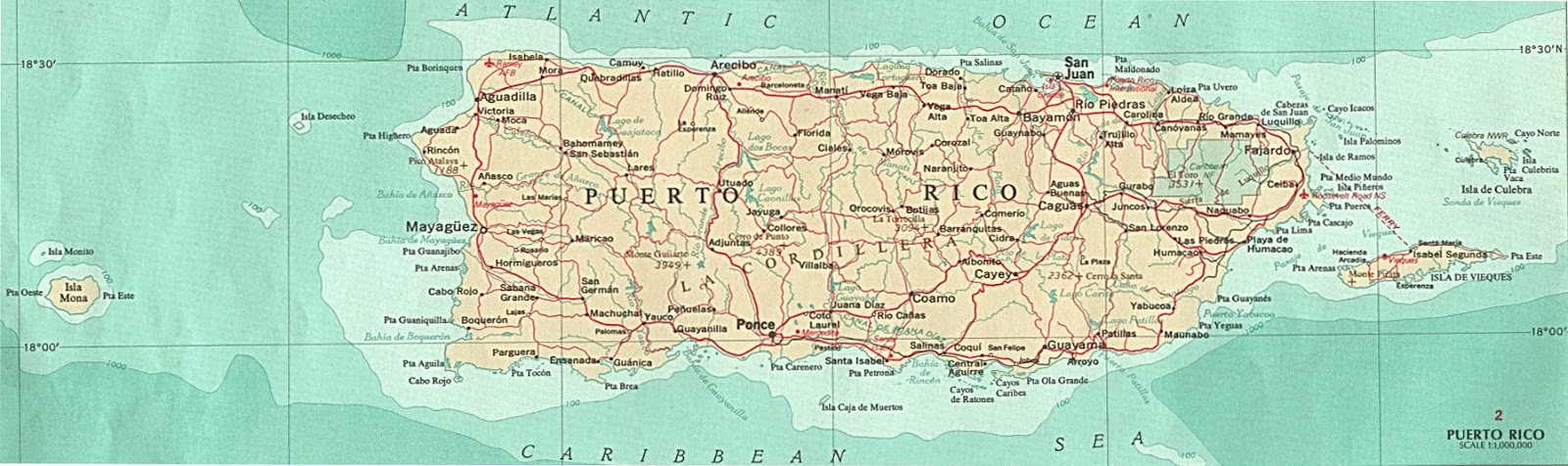 The northernmost point of the Indian Ocean is located at approximately 30° north latitude in the Persian Gulf. The width of the Indian Ocean is approximately 10,000 km between the southern points of Australia and Africa.
nine0003
Arctic Ocean: 1 – North Pole; 2 – North magnetic pole; 3 – North geomagnetic pole; 4 – North Pole of Inaccessibility
Southern Ocean
The Arctic Ocean (Eng. Arctic Ocean, Dan. Ishavet, Norwegian and Nynorsk Nordishavet) is the smallest ocean on Earth, located between Eurasia and North America. The area is 14.75 million km², that is, a little more than 4% of the total area of the World Ocean, the volume of water is 18.07 million km³. The Arctic Ocean is the shallowest of all oceans, with an average depth of 1,225 m (greatest depth of 5,527 m in the Greenland Sea) [10] .
Southern Ocean is the southernmost ocean on Earth. Surrounds Antarctica, area 20.327 million km², average depth 3270 m, water volume 72.37 million km³. The greatest depth in the South Sandwich Trench is 8264 m. The Southern Ocean is washed in the north by the Indian Ocean, the southeast by the Pacific Ocean, and in the northwest by the Atlantic Ocean. The coldest ocean, the average temperature is -12 ° C.
Formation of the oceans0011 [11]
that the ocean appeared 3.5 billion years ago as a result of degassing of magma and subsequent condensation of atmospheric vapors. Most of the modern ocean basins arose in the last 250 million years as a result of the splitting of the ancient supercontinent and the divergence to the sides (the so-called spreading) of the lithospheric plates. The exception is the Pacific Ocean, which is a dwindling remnant of the ancient ocean of Panthalassa [11] .
Bathymetric positionEdit
According to the bathymetric position and the nature of the relief on the ocean floor, several of the following steps are distinguished:
- shelf – depth up to 200-500 m;
- continental slope – depth up to 3500 m;
- Ocean bed – depth up to 6000 m;
- Deep sea trenches – depths below 6000 m.

Ocean and atmosphereEdit
Ocean and atmosphere are fluids. The properties of these environments determine the habitat of organisms. Currents in the atmosphere affect the general circulation of water in the oceans, and the properties of ocean waters depend on the composition and temperature of the air. In turn, the ocean determines the main properties of the atmosphere and is a source of energy for many processes occurring in the atmosphere. The circulation of water in the ocean is affected by winds, the rotation of the Earth, as well as land barriers.
nine0003
The ocean heats up more slowly in summer and cools more slowly in winter. This allows you to smooth out temperature fluctuations on land adjacent to the ocean.
The atmosphere receives from the ocean a significant part of the heat coming to it and almost all of the water vapor. The vapor rises and condenses to form clouds that are carried by the winds and fall as rain or snow on land. Only the surface waters of the ocean participate in heat and moisture exchange. Internal ones (about 95%) do not participate in the exchange [11] . During evaporation, a separation occurs according to the chemical composition: salts remain in the ocean, and the steam is almost free of them. Subsequent precipitation forms the main source of fresh water.
Chemical composition. There is a constant renewal of mineral deposits, by falling or bringing to the bottom of various sediments and solutions from the earth’s crust.
nine0003
The average salinity of sea water is 35 ‰ [11] . The salty taste of water is given by the 3.5% of dissolved minerals contained in it – these are mainly sodium and chlorine compounds.
Due to the fact that the water in the ocean is constantly mixed by waves and currents, its composition is almost the same in all parts of the ocean.
Additional information: Flora and Fauna
The Pacific Ocean accounts for more than 50% of the total biomass of the world’s oceans. Life in the ocean is abundant and varied, especially in the tropical and subtropical zones between the coasts of Asia and Australia, where vast areas are occupied by coral reefs and mangroves. The phytoplankton of the Pacific Ocean mainly consists of microscopic unicellular algae, numbering about 1300 species. Fucus, large green and especially well-known red algae are especially common in the tropics, which, along with coral polyps, are reef-forming organisms [12] .
The flora of the Atlantic is distinguished by species diversity. The water column is dominated by phytoplankton, consisting of dinoflagellates and diatoms. At the height of their seasonal bloom, the sea off the coast of Florida turns bright red, and a liter of sea water contains tens of millions of single-celled plants. The bottom flora is represented by brown (fucus, kelp), green, red algae and some vascular plants. In the mouths of the rivers, sea zoster, or eelgrass, grows, and in the tropics, green (caulerpa, wallonia) and brown (sargasso) algae predominate. The southern part of the ocean is characterized by brown algae (fucus, forestia, electus). The fauna is distinguished by a large – about a hundred – number of bipolar species that live only in cold and temperate zones and are absent in the tropics. First of all, these are large sea animals (whales, seals, fur seals) and ocean birds. Sea urchins, coral polyps, sharks, parrot fish and surgeon fish live in tropical latitudes. Dolphins are often found in the waters of the Atlantic. Cheerful intellectuals of the animal world willingly accompany large and small vessels – sometimes, unfortunately, falling under the ruthless blades of propellers. The native inhabitants of the Atlantic are the African manatee and the largest mammal on the planet, the blue whale.
nine0003
The flora and fauna of the Indian Ocean are extremely diverse. The tropical region stands out for its abundance of plankton. The unicellular alga Trichodesmium (a type of Cyanobacterium) is especially abundant, due to which the surface layer of water becomes very cloudy and changes its color. The plankton of the Indian Ocean is distinguished by a large number of night-luminous organisms: peridine, some species of jellyfish, ctenophores, and tunicates. Brightly colored siphonophores, including poisonous physalia, are abundant. In temperate and arctic waters, the main representatives of plankton are copepods, euphuazids, and diatoms. The most numerous fish of the Indian Ocean are dolphins, tuna, notothenia and various sharks. From reptiles there are several species of giant sea turtles, sea snakes, from mammals – cetaceans (toothless and blue whales, sperm whales, dolphins), seals, sea elephants. Most cetaceans live in temperate and polar regions, where, due to the intensive mixing of waters, favorable conditions arise for the development of planktonic organisms. The flora of the Indian Ocean is represented by brown algae (Sargasso, Turbinarium) and green algae (Caulerna). The calcareous algae of lithotamnia and chalimed also flourish, which, together with corals, participate in the construction of reef structures. Typical for the coastal zone of the Indian Ocean is a phytocenosis formed by mangroves. For temperate and Antarctic waters, the most characteristic are red and brown algae, mainly from the groups of fucus and kelp, porphyry, and helidium.
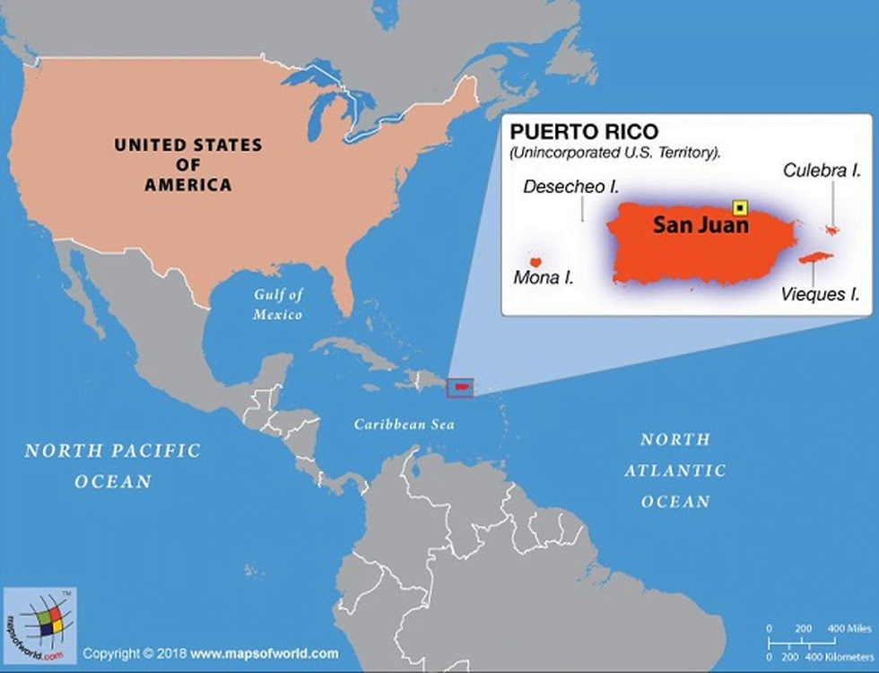 In the subpolar regions of the southern hemisphere there are giant macrocystis [13] .
The reason for the poverty of the organic world of the Arctic Ocean is the harsh climatic conditions. The only exceptions are the North European Basin, the Barents and White Seas with their extremely rich flora and fauna. The flora of the ocean is represented mainly by kelp, fucus, anfeltia, and in the White Sea – also zostera. The bottom fauna of the seas of the eastern Arctic is extremely poor, especially in the central part of the Arctic Basin. There are more than 150 species of fish in the Arctic Ocean, among them a large number of commercial fish (herring, cod, salmon, scorpion fish, flounder and others). Seabirds in the Arctic lead a predominantly colonial lifestyle and live on the shores. Mammals are represented by seals, walruses, beluga whales, whales (mainly minke and bowhead whales), and narwhals. Lemmings are found on the islands, arctic foxes and reindeer come along the ice bridges. The polar bear, whose life is mainly associated with drifting, pack ice or coastal fast ice, should also be considered a representative of the ocean fauna. Most animals and birds all year round (and some only in winter) are white or very light in color [14] [15] .
Extraterrestrial oceansEdit
The world ocean is not the largest in the solar system: in addition to it, there are a number of subglacial oceans in icy moons and dwarf planets. Some of these oceans (the oceans of the Galilean satellites Europa, Ganymede and Callisto and some dwarf planets) are several times larger than the World Ocean in volume, and in some (the oceans of Europa and Enceladus) the existence of extraterrestrial life is potentially possible. In the foreseeable future, all these oceans are unattainable for mankind, since to get into them it is necessary to melt tens of kilometers of ice on an extraterrestrial body.
nine0003
Even larger liquid oceans may exist on the ice giants Uranus and Neptune.
In other star systems, there are also oceanic planets completely covered with ice or, if the planet falls into the habitable zone, with liquid water.
If humanity is destined to become a space species, these oceans could become the main source of sustaining life beyond Earth.
The ocean in literature Selected novels and short stories. nine0024
- Wiktionary meanings
- Wikiquote citations
- Wikimedia Commons media files
- Oceans
- Ancient Oceans
- Sea water
- Mainland
- Ocean pollution
- Planet-ocean
- World Oceans Day
- Ocean Planet (film)
nine0023 World Ocean (mythology)
- Retrieved 13 March 2012. Archived from the original on 19 May 2012.
- ↑ Tomilin A.N. How people settle in the oceans of the Earth. – L .: Children’s literature. – 1985. – 157 p.
- ↑ Limits of Oceans and Seas, 3rd edition. International Hydrographic Organization, 1953 (undefined) . Retrieved 21 August 2010. Archived from the original on 8 October 2011. nine0343
- ↑ About.com:Geography: The Fifth Ocean (undefined) . Retrieved 27 July 2009. Archived February 2, 2012.
- ↑ Serebryakov V. V. Geography of sea routes. – M. : Transport, 1981. – S. 9-30.
- ↑ Kaplin P. A., Leontiev O. K., Lukyanova S. A., Nikiforov L. G. Berega. – M. : Thought, 1991. – S. 355-356.
- ↑ 1 2 Ryabchikov, 1988, p. 527-530.
- ↑ Great Russian Encyclopedia. T.11. – M. : Great Russian Encyclopedia, 2008. – S. 228.
- ↑ Great Russian Encyclopedia. T. 2. – M. : Great Russian Encyclopedia, 2005. – S. 445.
- ↑ Ryabchikov, 1988, p. 546-551.
- ↑ 1 2 3 4 Edited by prof. A.P. Gorkina. ocean // Geography. Modern illustrated encyclopedia. — M.: Rosmen (Russian) . — 2006.
- ↑ Ryabchikov, 1988, p. 521-526.
- ↑ Ryabchikov, 1988, p. 530-535.
- ↑ Ryabchikov, 1988, p. 551-558.
- ↑ Animals of the Arctic and Subarctic (indefinite) . Third planet. Retrieved 17 January 2012. Archived 2 February 2012. nine0343
 – L .: Children’s literature. – 1985. – 157 p.
 – S. 228.
- Physical geography of continents and oceans / Ed. ed. A. M. Ryabchikova. – M. : Higher School, 1988.
- Lebedev VL, Aizatullin TA, Khailov KM Ocean as a dynamical system. – L. : Gidrometeoizdat, 1974. – 208 p. — 13,000 copies.

- Oceans and seas Archived May 19, 2012. .
- P. Yu. Plechov Origin of the Ocean Archival copy of November 6, 2011 at the Wayback Machine. nine0024
US states | US Encyclopedia
US states map
US state map made up of state flags
The United States of America is a federal state with fifty states as subjects. US states
share sovereignty with the federal government of the United States, delegating to it a number of stipulated by the Constitution
US functions (defense, foreign relations and others). At the same time, the states remain independent in many
critical issues such as crime control, education, health and
transport. nine0003
Each of the states is governed by the same scheme of separation of powers (legislative, executive and judicial) as
federal government of the United States. The legislatures of the forty-nine states are,
like the US Congress, from two chambers (the exception is Nebraska, where
legislators have only one chamber). The head of state executive power is the governor.
| State | Full name | Designation | Founded | Capital |
|---|---|---|---|---|
| Idaho | State of Idaho | ID | July 3, 1890 | Boise |
| Iowa | State of Iowa | IA | December 28, 1846 | Des Moines |
| Alabama | State of Alabama | AL | December 14, 1819 | Montgomery |
| Alaska | State of Alaska | AK | January 3, 1959 | |
| Arizona | State of Arizona | AZ | February 14, 1912 | Phoenix |
| Arkansas | State of Arkansas | AR | June 15, 1836 | Little Rock |
| Wyoming | State of Wyoming | WY | July 10, 1890 | Cheyenne |
| Washington | State of Washington | WA | November 11, 1889 | Olympia |
| Vermont | State of Vermont | VT | March 4, 1791 | Montpelier |
| Virginia | Commonwealth of Virginia | VA | June 25, 1788 | Richmond |
| Wisconsin | State of Wisconsin | WI | May 29, 1848 | Madison |
| Hawaii | State of Hawaii | HI | August 21, 1959 | Honolulu |
| Delaware | State of Delaware | DE | December 7, 1787 | Dover |
| Georgia | State of Georgia | GA | January 2, 1788 | Atlanta |
| West Virginia | WV | June 20, 1863 | Charleston | |
| Illinois | State of Illinois | IL | December 3, 1818 | Springfield |
| Indiana | State of Indiana | IN | December 11, 1816 | Indianapolis |
| California | State of California | CA | September 9, 1850 | Sacramento |
| Kansas | State of Kansas | KS | January 29, 1861 | Topeka |
| Kentucky | Commonwealth of Kentucky | KY | June 1, 1792 | Frankfort |
| Colorado | State of Colorado | CO | August 1, 1876 | Denver |
| Connecticut | State of Connecticut | CT | January 9, 1788 | Hartford |
| Louisiana | State of Louisiana | LA | April 30, 1812 | Baton Rouge |
| Massachusetts | Commonwealth of Massachusetts | MA | February 6, 1788 | Boston |
| Minnesota | State of Minnesota | MN | May 11, 1858 | Saint Paul |
| Mississippi | State of Mississippi | MS | December 10, 1817 | Jackson |
| Missouri | State of Missouri | MO | August 10, 1821 | Jefferson City |
| Michigan | State of Michigan | MI | January 26, 1837 | Lansing |
| Montana | State of Montana | MT | Helena | |
| Maine | State of Maine | ME | March 15, 1820 | Augusta |
| Maryland | State of Maryland | MD | April 28, 1788 | Annapolis |
| Nebraska | State of Nebraska | NE | Lincoln | |
| Nevada | State of Nevada | N. V. V. | October 31, 1864 | Carson City |
| New Hampshire | State of New Hampshire | NH | June 21, 1788 | Concord |
| New Jersey | State of New Jersey | December 18, 1787 | Trenton | |
| New York | State of New York | NY | July 26, 1788 | Albany |
| New Mexico | State of New Mexico | NM | January 6, 1912 | Santa Fe |
| Ohio | State of Ohio | March 1, 1803 | Columbus | |
| Oklahoma | State of Oklahoma | OK | November 16, 1907 | Oklahoma City |
| Oregon | State of Oregon | OR | February 14, 1859 | Salem |
| Pennsylvania | Commonwealth of Pennsylvania | PA | December 12, 1787 | Harrisburg |
| Rhode Island | State of Rhode Island | RI | May 29, 1790 | Providence |
| North Dakota | State of North Dakota | ND | November 2, 1889 | Bismarck |
| North Carolina | State of North Carolina | NC | November 21, 1789 | Roles |
| Tennessee | State of Tennessee | TN | June 1, 1796 | Nashville |
| Texas | State of Texas | TX | December 29, 1845 | Austin |
| Florida | State of Florida | FL | March 3, 1845 | Tallahassee |
| South Dakota | State of South Dakota | SD | November 2, 1889 | Pierre |
| South Carolina | State of South Carolina | SC | May 23, 1788 | Columbia |
| Utah | State of Utah | UT | January 4, 1896 | Salt Lake City |
In the New York State Legislature
, the US Congress can admit new states to the state, the last to enter today
the US state of Hawaii (in 1959). Currently the most likely candidate for status
the 51st state of the US is Puerto Rico. The US Constitution does not say anything about whether a particular state has
the right to secede from the United States. In 1861, such a decision of the southern states led to a civil war, so the US Supreme Court
declared secession attempts illegal. nine0003
state
Colorado – “State of Colorado”), four US states are called “commonwealths” ( commonwealth ,
e.g. Commonwealth of Kentucky – “Commonwealth of Kentucky”). This situation has developed historically and no
There are no legal differences between states with different names.
States in the USA, in turn, are divided into districts (counties), city-counties (a city that has the status of a district) and independent
cities (cities that do not belong to any district). The District of Columbia has a special status, in which it is located
Washington DC is the capital of the United States of America.