Tres picachos puerto rico: Best trails in Tres Picachos State Forest
The Most Challenging Hikes in Puerto Rico
The Lluberas trail is the longest trail in the Dry Forest at nearly 10 miles round trip and has several side trails.
Prepare to get sweaty and enjoy some of the best views the island has to offer.
Push your limits and be handsomely rewarded.
The best part of a challenging hike, the type that requires ropes, trekking poles, hours of walking, and more water and snacks than you think you’ll need, is that when you reach the peak, the beach, the bottom of the canyon, the payoff is that much sweeter for your extraordinary effort. Puerto Rico has several such hikes, each with radically different conditions and requirements.
Get your gear together, make sure you’re physically fit, and don’t forget your camera.
Tres Picachos
Jayuya
The municipality of Jayuya in the island’s Cordillera Central (central mountain range) has several imposing peaks, including Cerro Punta, the highest point in Puerto Rico. But for a challenging hike, head to Los Tres Picachos, a three-peaked, 3,953 ft mountain with an ascent so steep, there are ropes tied to the trees to help hikers go up. The view from the top is breathtaking and the adventure of climbing will make it even more meaningful.
Ascent and descent take around two and a half hours each way and require hikers to be in excellent physical condition. Long pants, hiking shoes, and a windbreaker are recommended, as well as enough food and water for the long hike. Be aware that rain can cause mudslides around the trail.
El Yunque is the quintessential stop for nature lovers and hiking aficionados.
El Toro Trail at El Yunque
Río Grande
After Hurricane María, only a handful of trails are open in El Yunque National Forest and one of them is El Toro, which takes you to the highest point of the rainforest. The trail is muddy, parts of it are unkempt and require climbing over rocks and trees, but for the most part, it’s a smooth trail with a steep descent upon reaching El Toro Peak. The forest landscape changes from tabonuco trees to sierra palms to stunted trees near the top, which is what they call the “cloud forest.” Wear long pants and long sleeves that are breathable in heat and humidity, shoes with great traction, and bring plenty of food and water. Since the canopy is still filling out, sunscreen is also a good idea.
El Toro Trail used to connect with the Trade Winds trail but this one is still closed to the public. Since El Toro is more remote than the more “mainstream” El Yunque trails, please be sure to stay on the trail itself and not wander off.
Cañón San Cristóbal
Barranquitas/Aibonito
Cañón San Cristóbal is a 5.6-mile canyon created by tectonic movements which essentially split open the central mountain range. The Usabón river crosses the bottom of the canyon which also contains natural swimming holes and some of the most impressive waterfalls in Puerto Rico. This is a hike that requires a guide and safety equipment because both descending and ascending are incredibly steep and tricky. Several companies like Go Hiking Puerto Rico and Para La Naturaleza, the nonprofit conservation organization that acquired the canyon and gave it protected status, organize excursions of different difficulty levels, some just hiking, others with rappelling included.
From the rainforest to dry forest, the Island’s landscape is rich in diversity.
Ballena and Lluberas Trails at the Guánica Dry Forest
Guánica
This is probably the “easiest” of the challenging hikes since the ascent and descent are doable even for the average hiker. What will test you is the heat. You’ll be crossing a subtropical dry forest with desert-like conditions and the length of the hike will take you into the hottest parts of the day.
The Ballena trail reaches Ballena beach at the bottom of the Bosque Seco de Guánica and you can continue your hike along the beach to the mangrove area at the end. But eventually you need to come back up the mountain. The Lluberas trail is the longest trail in the Dry Forest at nearly 10 miles round trip and has several side trails, some reach the beach at the bottom of the mountain and one called Cueva reaches several limestone caves.
To enter the reserve, visit the ranger station (located at the top of the mountain) where you check in and receive a map. The ranger is happy to recommend trails depending on how long you want to be out. Bring plenty of water and food, clothes that breathe but will protect you from the sun, sturdy shoes, and insect repellent.
This forest is best visited during the “winter” months; during the summer the heat rises substantially and can be dangerous.
The name of the mountain itself is Cerro de los Cielos but the trail gets its name from the solitary mango tree at the top which is visible from the highway
Árbol Solitario
Salinas
Árbol Solitario, the lonely tree, is a famous trail locally, despite the steep, more than 90-minutes and nearly 2,000-foot ascent.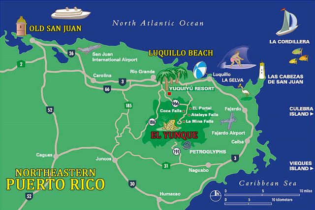 But it’s all worth it for the panoramic view of the mountains stretching all the way to the Caribbean Sea. The name of the mountain itself is Cerro de los Cielos but the trail gets its name from the solitary mango tree at the top which is visible from the highway. The tree has two swings attached to its branches and further down the trail there are also flagpoles with tattered remains of several flags. All of these are prime photo opportunities.
The trail became somewhat infamous in 2016 because people used to park on the highway emergency ramp (which is illegal) for a shorter route up to the tree. Many ended up getting lost on the way up causing a huge headache for the local police. To reach the “official” trailhead, you need to get off the PR-52 highway to the PR-1 road in the direction of Cayey, there is a parking lot at Hacienda Los Maldonado. From there you can head up the mountain.
View Places Mentioned on a Map
Share this
Tags
Things to Do
Outdoors
Hiking
Recommended Articles
See All Articles
Hiking Trails in Puerto Rico
Boasting the only tropical rainforest in the United States National Forest System, a stunning dry forest, and other geological wonders, it’s no surprise that Puerto Rico is a popular destination for hikers and nature lovers.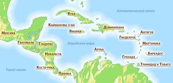 Hiking in Puerto Rico is full of surprises, from unique wildlife and a wide variety of plants to breathtaking views you won’t find anywhere else.
You can find amazing hiking trails all over the island, from the popular rainforest trails at El Yunque to challenging hikes at Tres Picachos. Whether you’re looking for a relaxing nature walk or an adventure, Puerto Rico has a hiking trail for you. This list includes trails for all levels of hikers and in different regions of the island. Pack your hiking gear and get ready for a memorable experience!
El Yunque is one of the top attractions visitors want to explore on a trip to Puerto Rico, and for good reason. This highly biodiverse forest is full of amazing things to discover, including natural pools and waterfalls, beautiful wildlife, and at least 240 different species of plants. Adventures abound in this unique rainforest, and there are hiking trails for all types of travelers.
Book El Yunque Hiking Tour
Book El Yunque Hiking Tour
Caimitillo Trail
Distance: 0. 4 miles
Difficulty: Easy
If you’re visiting El Yunque with the whole family, Caimitillo Trail is a perfect way to discover the rainforest on a relaxing walk that everyone can enjoy. It features rich foliage and opportunities to spot wildlife as you stroll along comfortable pathways, and you can find some great picnic spots to enjoy the atmosphere and rest. This short trail also leads to other, more challenging trails, so it’s a great starting point.
Angelito Trail
Distance: 0.7 miles
Difficulty: Easy
Although Angelito Trail isn’t on the forest map for El Yunque, it’s a great hike that takes you to a refreshing swimming spot. This easy nature trail is perfect for observing wildlife and enjoying the rainforest with the whole family. The vegetation is different from what you might see higher up in the forest, and it includes breadfruit trees and philodendrons. The short trail ends at Las Damas pool in the Mameyes River, which has crystal-clear waters and a rope swing. For an extra special experience, enjoy the hike at night and discover the nocturnal wildlife on the tour below.
Book Angelito Tour
Book Angelito Tour
El Toro Wilderness Trail
Distance: 2.3 miles (or up to 12.5 miles when all sections are open)
Difficulty: Challenging
This trail can get challenging, but the effort takes you to the highest peak in the Luquillo Mountains, El Toro Peak. This is one of the best hikes in Puerto Rico and one that hiking enthusiasts should definitely add to their bucket list. It can get a bit muddy and has some unkempt areas, but for the most part, it’s a smooth trail with a steep climb. One of the best features is you can see the trees change as you reach the top, where only a “cloud forest” of stunted trees can grow. While this trail used to connect to the Trade Wind Trail, that section is currently closed to the public.
Charco Azul Trail – Carite State Forest
Distance: 0..jpg) 8 miles
8 miles
Difficulty: Easy
Just an hour outside of San Juan, you can find this tranquil trail near San Lorenzo on the east of the island. Charco Azul Trail is perfect for families, beginners, and anyone who wants to enjoy a leisurely walk ending at a beautiful swimming spot. The trail is paved all the way, featuring small bridges that cross over rivers. The best is saved for last — the stunning Charco Azul is a beautiful blue lake where you can take a refreshing swim at the end of your hike. The area has breathtaking views and plenty to explore, including caves and rock formations. Just remember to use caution, as the pools are deep and there are slippery cliffs.
Ballena Trail – Guánica Dry Forest
Distance: 2.4 miles
Difficulty: Easy but hot
Located on the south side of the island, the Guánica Dry Forest has an arid climate with desert-like conditions. Its features are almost the complete opposite of El Yunque — you can find cacti and other similar plants in this subtropical dry forest. Ballena Trail leads to Ballena Beach, known for its mangrove area, and you can also find limestone caves to explore. This slightly uphill hike is not technically challenging, but the heat can make the conditions difficult. It’s best to visit during the winter months and avoid the hottest times of the day.
Interpretive Trail – Guajataca Forest
Distance: 2 miles
Difficulty: Medium
Located in Isabela, the Guajataca Forest is a must-visit if you’d like to explore the karst region of Puerto Rico. The forest has 25 miles of trails, but the Interpretive Trail is one of the most popular. Starting by the Information Center, it takes you in a circle, and you can see birds and butterflies along the way. You can also take a quick detour to see the Observation Tower. Although the trail is relatively short and easy, it has some steep sections — including the steps up to the observation tower — that make it a bit more challenging.
Guajataca Forest Reserve – Puerto Rico
Árbol Solitario – Salinas
Distance: 1 mile
Difficulty: Challenging
At the top of Cerro de los Cielos stands a lonely mango tree that attracts countless hikers who want to enjoy the stunning views from the peak. Located between Cayey and Salinas, the peak that Árbol Solitario calls home offers beautiful landscapes everywhere you look, from the local towns and mountains to the Caribbean Sea. The tree has two swings for iconic photo opportunities. While some hikers used to take a shortcut to the trail by parking on a highway emergency ramp, this is illegal, so be sure to follow the official trail, which begins off of highway PR-1. The hike is steep and challenging, but the views at the top are worth it.
Tres Picachos – Jayuya
Distance: 2.8 miles
Difficulty: Challenging
If you’re looking for a mountain hike with plenty of opportunities for wildlife sightings, Tres Picachos is a great option. This three-peaked mountain located in the Cordillera Central in Jayuya offers an adventurous hike and amazing views that you’ll never forget. The hike poses a challenge, with a steep ascent that is aided in part by ropes tied to the trees. The trail can get a bit muddy if it rains, so be sure to wear appropriate hiking attire, and bring plenty of water and snacks.
The beauty of Puerto Rico is best experienced on a hike, allowing you to connect with nature and experience the beauty of the island. Choose your hike based on your experience and how much you want to challenge yourself. No matter which trails you decide to visit, you’re sure to enjoy a memorable day in nature. For the most challenging hikes, it’s always a good idea to hike with an experienced guide. Now get out there and get to know the best of Puerto Rico!
Puerto Rico list
Tazi is a state of origin in the Commonwealth of Puerto Rico.
STRACTION
- 1 DRZHAVNI Gori in Poerto RIKO
- 2 VITESCHECE
- 3 Belezhs
- 4 Pretens
- 5 VRIZHOTA RIKOTA. Follow Poerzhavni in Poerto Rico
[Belezka 1]
Not. nine Land Procurement: As of August 2013, the Government of Puerto Rico is pursuing the current plan for the purchase of land with a target increase in inventory for the state land.  As a result, on the subject, give for the area, give a table in the basin, tryabva, and all will be accepted as an approximation. If so, measure per land in Puerto Rico sada dadeni at cuerdas (one cuerda ce equal to 0.97 acres) and kato taquiva, preprate the size meter on the burn in the daly sa conversion to acre, for yes it will support all the similar measurements in the tazi article. nine Bosque de Puerto Rico: Bosque Estatal de Vega. PR dRNA. Jojas de Nuestro Ambiente. Publication # P-033. October 2008. Visited on August 20, 2013.
foreign injection
- Puerto Rico Department of Natural and Environmental Resources (Spanish)
Morilito – Wikipedia
Morilito is a small uninhabited island off the coast of Puerto Rico. The island is protected from Reserva Natural Caja de Muertos natural reserve for rodnia and costenurka traffic.
[1] Close to Caja de Muertos, Gatas, Ratones, Cardona, Isla del Frio, and Isla de Jueyes, Morrillito is one of seven islands, assigned to the community of Ponce. [2] [3] School
- 1 Location
- 2 Geography and climate
- 3 Nature Reserve
- 4 VITE OSCOSE0012
Location
Island, erroneously called a cay (or, key), namir se 8.4 km south of the continental part of Puerto Rica and part of Bario Playa [4] [5] branch from Ponce, Puerto Rico, community. Namira is 180 meters from the southwestern point on Caja de Muertos Island and is about 0.015 square miles (0.04 km 2 ). The island is connected with Caja de Muertos from the shore to the tiles of the water from the dalbochin about 5.49 meters. [6] Namira is at 17.88417 geographic width and -66.53361 geographic length. [7] Dalzhinata mu e 0.5 kilometers to the northeast and southwest.
[8] Geography and climate
Island small 31-foot flat island, located 200 yards from the southwest edge of Caja de Muertos and, seen from a distance, Morrillito Forest can be 170-foot strjmen khulm (named Cerro Morrillo, Morilo Gil ) in the southwestern region of Caya de Muertos. nine0025 [9] [10] The climate is dry and the island supports a dry mountain.
Natural reserve
Zaedno with Caja de Muertos (0.59 square miles) (1.54 km 2 ) and Berberia Key (0.12 square miles) (0.30 km.) 2 ), Morrillito Caja de Muertos Natural Reserve . The island was designated as a natural reserve in 1980, a trace of the kato in Puerto Rico crossed from the Sveta for planning to Puerto Rico, some of the sightings of the preporkata, set out from the Programat for the coastal zone for the transition to the islands in protectiondiva zone Ottogawa islands remained protected zone. nine Isla Caja de Muerto natural reserve .
 As a result, on the subject, give for the area, give a table in the basin, tryabva, and all will be accepted as an approximation. If so, measure per land in Puerto Rico sada dadeni at cuerdas (one cuerda ce equal to 0.97 acres) and kato taquiva, preprate the size meter on the burn in the daly sa conversion to acre, for yes it will support all the similar measurements in the tazi article. nine Bosque de Puerto Rico: Bosque Estatal de Vega. PR dRNA. Jojas de Nuestro Ambiente. Publication # P-033. October 2008. Visited on August 20, 2013.
 [1] Close to Caja de Muertos, Gatas, Ratones, Cardona, Isla del Frio, and Isla de Jueyes, Morrillito is one of seven islands, assigned to the community of Ponce. [2] [3]
  [8]
[8] 