What is the weather like in puerto rico: Puerto Rico Climate, Weather By Month, Average Temperature (Puerto Rico)
The Climate and Geography of Puerto Rico
Geography of Puerto Rico
Puerto Rico is a rectangular island, situated roughly in the middle of the Antilles, a chain of islands that stretches from Florida to Venezuela and forms the dividing line between the Atlantic Ocean and the Caribbean Sea. The Antilles are divided into two regions—Greater Antilles and Lesser Antilles. Puerto Rico is the smallest and easternmost island of the Greater Antilles, which include Cuba, Hispañola (Dominican Republic and Haiti), and Jamaica.
In addition to the main island, which is 111 miles east to west and 36 miles north to south, Puerto Rico comprises several tiny islands or cayos, including Mona and Desecheo off the west coast and Vieques, Culebra, Palomino, Icacos, and others off the east coast. The northern and eastern shores of Puerto Rico are on the Atlantic Ocean, and the southern shores are on the Caribbean Sea. To the west is Mona Passage, an important shipping lane that is 75 miles wide and 3,300 feet deep.
Photo © Christian Ouellet/Dreamstime.
The island was believed to have been formed between 135 million and 185 million years ago when a massive shift of tectonic plates crumpled the earth’s surface, pushing parts of it down into deep recesses below the ocean floor and pushing parts of it up to create the island. This tectonic activity resulted in volcanic eruptions, both underwater and above it.
Two significant things happened as a result of all this geologic activity. The Puerto Rico Trench was formed off the island’s north coast. At its greatest depth, it is 28,000 feet below sea level, making it the deepest point known in the Atlantic Ocean. Secondly, it formed the mountainous core of Puerto Rico that spans nearly the entire island from east to west and reaches heights of 4,390 feet above sea level. Volcanic activity is believed to have been dormant in Puerto Rico for 45 million years, but the earth is always changing. The Caribbean plate is shifting eastward against the westward-shifting North American plate, which has resulted in occasional earth tremors through the years. Although this activity is suspected to have led to the volcanic activity in Montserrat in recent years, its danger to Puerto Rico is its potential to cause earthquakes, not volcanic activity.
Puerto Rico has three main geographic regions: mountains, coastal lowlands, and karst country. More than 60 percent of the island is mountainous. The island’s mountains, which dominate the island’s interior, comprise four ranges: Cordillera Central, Sierra de Cayey, Sierra de Luquillo, and Sierra de Bermeja. The largest and highest range is Cordillera Central, which spans from Caguas in the east to Lares in the west. Its highest point is Cerro Punta (4,390 feet above sea level), in the Bosque Estatal de Toro Negro near Jayuya. Sierra de Luquillo is in the northeast and contains the Caribbean National Forest, home to El Yunque rainforest. These two mountain ranges feature dramatic pointed peaks and lush tropical vegetation. Sierra de Cayey, in the southeast between Cayey and Humacao, and Sierra de Bermeja, in the southwest between Guánica and the island’s southwestern tip, are smaller in area and height, drier, and less forested.
The coastal lowlands span more than 300 miles around the rim of the island, 8-12 miles inland in the north and 2-8 miles inland in the south. Formed through time by erosion of the mountains, the coastal lowlands are important agricultural areas that benefit from the rich soil and water that wash down from the mountains. Much of the area is defined by sandy or rocky beaches and mangrove swamps, although the mangrove forests are being whittled away by development.
The island’s third region is unique. The karst region spans the island’s northern interior, from San Juan in the east to Aguadilla in the west, and the southern interior, from Ponce in the east to San Germán in the west. It can also be found in isolated pockets throughout the island, as well as on Mona Island off the west coast. The karst region is distinguished by a fascinating landscape of sinkholes, cliffs, caves, and conical, haystack-shaped hills called mogotes. More than 27 percent of Puerto Rico’s surface is made up of limestone, and its erosion from rain helped create the beguiling patchwork of hills and holes. One of limestone’s unique properties is that it reprecipitates and forms case rock that is impervious to chemical and climatic change, which has basically frozen the odd formations in time. In addition, water produced by reprecipitation bubbles up to hydrate the earth’s surface, and drips down, creating subterranean rivers and caves.
As a result of its karst region, Puerto Rico has some of the most significant cave systems in the western hemisphere and the third-largest underground river, Río Camuy. The public can tour part of the massive cave system at Las Cavernas del Río Camuy in the municipality of Camuy.
In addition to Río Camuy, Puerto Rico’s other major rivers include the north-running Grande de Arecibo, the island’s longest; La Plata, Cibuco, Loíza, and Bayamón, which run north; and Grande de Añasco, which runs west. There are no natural lakes in Puerto Rico, although 15 reservoirs have been created by damming rivers. But there are several natural lagoons, including Condado and San José in San Juan, Piñones and Torrecilla in Loíza, Joyuda in Cabo Rojo, Tortuguero in Vega Baja, and Grande in Fajardo.
Puerto Rico’s Climate
Puerto Rico’s climate is classified as tropical marine, which means it’s typically sunny, hot, and humid year-round. The temperature fluctuates between 76°F and 88°F in the coastal plains and 73-78°F in the mountains. Humidity is a steady 80 percent, but a northeasterly wind keeps things pretty breezy, particularly on the northeast side of the island.
Nobody wants rain during a tropical vacation, but precipitation is very much a part of life in Puerto Rico. Although there are periods when the deluge is so heavy that you might think it’s time to build an ark, rains are generally brief and occur in the afternoons. The average annual rainfall is 62 inches. Although it rains throughout the year, the heaviest precipitation is from May to October, which is also hurricane season. The driest period is January to April, which coincides with the tourism industry’s high season. Keep in mind that the north coast receives twice as much rain as the south coast, so if the outlook is rainy in San Juan, head south.
As the devastation of Hurricanes Irma and Maria in 2017 illustrated, tropical storms pose a very real threat to Puerto Rico. Much of the island was without electrical power for an entire year following Hurricane Maria, a category 4 storm that did $139 billion worth of damage to the island. An estimated 3,000 people died either as a direct result of the storm or because of medical complications due to lack of electricity.
But Hurricane Maria is a considered a “storm of the century,” meaning it was highly irregular and far from the norm. The previous biggest storm was Hurricane Georges, a category 3 that struck in 1998 and did $2 billion of damage.
According to the U.S. National Weather Service, hurricane season in the Caribbean spans from June through November, but August through October is when Puerto Rico is most vulnerable.
For the latest information on weather conditions in Puerto Rico, visit the National Weather Service.
Related Travel Guide
Relax beneath palm trees, kayak through bioluminescent bays, or dance the night away to the sounds of salsa: Experience the Island of Enchantment with Moon Puerto Rico.
Also Available From:
Buy Now:
Puerto Rico climate info | whats the weather like in Puerto Rico
The climate of Puerto Rico
Puerto Rico has a tropical climate with very warm weather all year
round with reasonably high precipitation figures, without a distinct
dry period. Winters are slightly drier than the rest of the year.
During the winter it is also colder and less muggy than during the
summer. Puerto Rico is the most popular tourist destination in the
Caribbean. The largest part of the tourists that travel to the
Caribbean go to Puerto Rico. More than 75% of the tourists come from
the United States of America. Puerto Rico is a popular stop-over and a
popular starting point for cruise lines. Many cruise ships make a
stop-over on this beautiful island. Officially the country is known as
the Commonwealth of Puerto Rico; it is an unincorporated territory of
the United States but is seen as an autonomous region in many ways.
Because the central part of Puerto Rico is a
mountainous region with its highest point at an altitude of 1,338
meters, the island can be divided into two parts. The northern part of
the island is slightly wetter. The southern and eastern part of the
island are situated on the leeward side and are consequently protected
from depressions. Because of this precipitation figures are lower
along the south coast from December till April. In the southern part
temperatures are 1-2 degrees lower on average than along the more
popular north coast.
Climate information of places and areas in Puerto Rico
The climate information on this page is only brief. Specific
information about weather and climate can be found on the climate
pages per area or town. As for Puerto Rico the following climate
information is available:
|
Ponce San Juan |
|
|
|
Summer in Puerto Rico
Summers in Puerto Rico (May-September) are slightly warmer than
winters and chances of unstable weather are slightly higher. Chances
of unstable weather are caused by a higher activity of depressions
coming from the Atlantic Ocean. These depressions may be very active
and cause heavy showers and fierce winds. In the worst case scenario a
depression grows into a tropical storm or hurricane. There is a risk
of hurricanes during hurricane season which is from June till the
beginning of December. However, if you travel to Puerto Rico during
this period you should not worry too much about hurricanes. The chance
of a hurricane hitting the part of the island where you stay is less
than one tenth of a percent. Daytime temperatures during the summer
are around 30 degrees Celsius (86.0 degrees Fahrenheit). During the
night temperatures remain well above 20 degrees Celsius (68.0 degrees
Fahrenheit) which is warm enough for a pleasant sunny holiday. During
this period you do not even need a jacket, sweater or cardigan.
Winter
Winters in Puerto Rico are warm with temperatures around 30 degrees
Celsius (86.0 degrees Fahrenheit). Minimum temperatures hardly ever
drop below 18 degrees Celsius (64.4 degrees Fahrenheit). Because of
this the climate of Puerto Rico can be classified as tropical. During
the winter chances of precipitation are smaller than during the
summer; chances of fierce winds are even much smaller. If you book a
cruise that makes a stop-over in Puerto Rico during the winter you
will not have to worry about it being cancelled or delayed because of
bad weather.
UV-index
UV-index figures are almost always high in Puerto Rico. With a maximum
figure of 11 during a large part of the year we advise you to apply
and re-apply sunscreen with a high protection factor.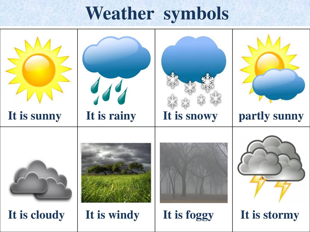
Extremes
Apart from hurricanes only few extremes in weather and climate can be
recorded in Puerto Rico. Wintry weather such as snow, glazed frost or
subzero temperatures are uncommon. Extremely hot weather with
temperatures of 40 degrees Celsius (104.0 degrees Fahrenheit) or
higher are uncommon as well. This is because of the tempering
influence of both the wind and sea
Climate figures
The figures below are based on long term weather and climate
records. They are an average for Puerto Rico. Local deviations may
occur, especially in the field of precipitation. For climate figures
on specific regions and places please, visit the individual climate
pages of Puerto Rico.
|
average |
average minimum temperature (C) |
average hours of sunshine per day |
average days with precipitation per month |
average mm precipitation per month |
average sea temperature (C) | |
|
January |
27 |
19 |
8 |
19 |
26 | |
|
February |
27 |
19 |
8 |
15 |
26 | |
|
March |
27 |
20 |
9 |
15 |
26 | |
|
April |
28 |
21 |
9 |
14 |
|
27 |
|
May |
29 |
22 |
8 |
16 |
|
27 |
|
June |
29 |
23 |
9 |
17 |
|
28 |
|
July |
30 |
23 |
9 |
19 |
|
29 |
|
August |
30 |
23 |
9 |
20 |
|
29 |
|
September |
30 |
22 |
8 |
17 |
|
29 |
|
October |
29 |
22 |
7 |
18 |
|
29 |
|
November |
28 |
21 |
7 |
19 |
|
28 |
|
December |
27 |
20 |
7 |
20 |
27 | |
|
= 0-5 mm ● = 6-30 mm ● = 31-60 mm ● = 61-100 mm ● = 101-200 mm ● = over 200 mm = 0-0.  2 inches ● = 0.2-1.2 inches ● = 1.2-2.4 inches ● = 2.5-4 inches ● = 4.1-8 inches ● = over 8 inches 2 inches ● = 0.2-1.2 inches ● = 1.2-2.4 inches ● = 2.5-4 inches ● = 4.1-8 inches ● = over 8 inches | ||||||
More climate information
Climate tables are useful but they dont give an overall picture of
the climate and possible weather conditions during a period of time.
How high the chances are of hot or cold weather or hurricanes can
often not be found in these tables. This is why we offer extra climate
information per month. The figures below are for Puerto Rico
|
chance of |
chance of (very) cool weather |
chance of long-term precipitation |
chance of hurricanes (cyclones) |
chance of sunny days |
| |
|
January | ||||||
|
February | ||||||
|
March | ||||||
|
April | ||||||
|
May | ||||||
|
June | ||||||
|
July | ||||||
|
August | ||||||
|
September | ||||||
|
October | ||||||
|
November | ||||||
|
December | ||||||
|
click here for the explanation of the symbols | ||||||
Disclaimer
The information at this site was carefully composed from climate data collected by meteorological services, meteorological offices, climate experts and other sources. More climate info is based on statistics, climate data and personal experience. No rights can be derived from this site. Weather has no memory and gives no guaranties. Nothing is as changeable and unpredictable as the weather. The authors of this site feel in no way responsible for any damages caused by misinterpretation or other circumstances that may influence your holiday or trip to a certain destination. We provide information, its up to the reader to use it to its benefit.
Weather in Puerto Rico (Gran Canaria) today. Weather forecast for the next 10 days
This data shows the current weather and forecast for the coming days in Puerto Rico. In addition to temperature, wind, humidity and pressure, we include precipitation probability data so that you can get all the information about your destination before your trip.
nine0014 December 17, 2022
| Night | ||
18. 9 ° C 9 ° C It is felt: 18.9 ° C | ||
| Morning | ||
| 18.8 ° C Consumes: 18.8 ° C | ||
| Wind: 2 m/s Pressure: 764 Humidity: 69% | Ver. Precipitation: 0% Visibility: 10 km UV Index: 5 | Day |
| 20.2 ° C Penins: 20.2 ° C | ||
| Wind: 1 c Pressure: 764 Humidity: 67% | Rev. precipitation: 0% Visibility: 10 km UV index: 6 | |
| Evening | ||
| 19.4°C Feels: 19.4°C | Clear Precipitation: 0% Visibility: 10 km UV index: 1 | |
Puerto Rico Marine Forecast
The graphs show the height and direction of the waves, as well as the speed and direction of the Puerto Rico wind for the coming days. Click on the sea state graph to learn more
Search for bathing spots according to your criteria
If you are planning a beach holiday and want to enjoy the warm sea, select the day of the year, the region and the minimum comfortable water temperature. As a result, you will receive a list of countries and cities in which the average water temperature for this day over the past 10 years exceeds the value you selected
- Region:
Australia and OceaniaAsiaAfricaMiddle EastEuropeNorth AmericaCentral America and the CaribbeanSouth America - Date (day and month):
12345678910111213141516171819202122232425262728293031
JanuaryFebruaryMarchAprilMayJuneJulyAugustSeptemberNovemberDecember - Water temperature:
>=16°C>=17°C>=18°C>=19°C>=20°C>=21°C>=22°C>=23°C>=24° C>=25°C>=26°C>=27°C
Medium temperature
Maximum temperature
What is the ideal water temperature for swimming?
Spain photo gallery
If you have interesting photos of this place and want to show them, upload them here. Photos for viewing will be available after their verification by the moderator
Water Temperature Widget
Puerto Rico’s water temperature is calculated using satellite data together with observations from ground stations. Water temperature, weather forecast and sea conditions are updated daily. Temperatures in shallow areas near the shore may be slightly higher than those shown here.
Puerto Rico de Puerto Rico ), or The Commonwealth of Puerto Rico (eng. Commonwealth of Puerto Rico ), is located in the Caribbean Sea on the island of Puerto Rico from the Greater Antilles group and a number of adjacent small islands. Puerto Rico is a US dependency and has the status of an “unincorporated organized territory” ( Unincorporated organized territory ), which means that this territory is under the control of the United States (and is not an integral part of them), the effect on the territory of the US Constitution is limited; supreme power belongs to the US Congress, but the territory has its own system of self-government. Puerto Rico has its own constitution, legislative, executive and judicial branches. The connection to the United States lies in the presence of a common citizenship, currency and defense. Due to the lack of a clear legislative framework for the status of the territory, this issue is being actively discussed on the island itself, in the United States and the UN. In 2000, by order of President Clinton, a special commission on the status of Puerto Rico was created (English President’s Task Force on Puerto Rico’s Status ). In its report, the commission confirmed the current status and recommended that the citizens of the island be granted the right to self-determination. It is assumed that within the framework of this procedure, Puerto Ricans will choose one of three options: securing their current status, joining the United States as a state, or gaining independence. The bill has been submitted to Congress for consideration. In 2012, a political status referendum was held in two stages. |
