Maricao: Maricao | Discover Puerto Rico
Maricao, Puerto Rico
(mah-ree-KOU)
Maricao is known as “El Pueblo de las Indieras”
(town of indian settlements). Maricao was founded on April 10, 1874 by Bernardo
Collado, Julián Ayala, Francisco M. Sojo Napoleón Pietri
and Leoncio S. Martínez.
Maricao Church
Photo: Jose Caraballo
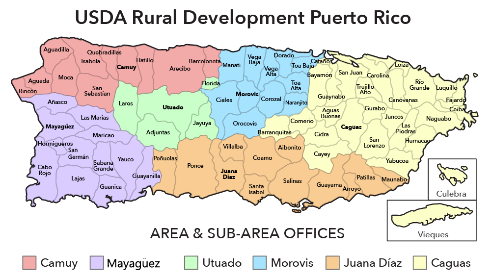
The town borders the Maricao Fish Hatchery, a collection of tanks and ponds in
a garden setting, where some 25,000 fish are raised yearly to stock farm
fishponds and island lakes. The hatchery is part of the Maricao Forest Reserve,
also known as Monte del Estado. Though of dryer vegetation than the other
mountain forest, The forest is home to large number of bird species and
a vast amount of flora, 582 species, 339 genera and 113 families. Its stone
observation tower provides far-flung views to the coast and the Mona Passage.
Economy
Maricao’s agriculture is a central part of the city’s economy, specifically coffee plantations. Maricao is known for
producting one of the best coffees in the island.
The city also producews fruits and vegetables.
Geography
Maricao, at the western edge of the mountains, is a small town
set around a small plaza in hilly terrain,
north of San Germán;, Sabana Grande and Yauco;
south of Las Marias and Lares;
southeast of Mayagüez; and west of Adjuntas.
Maricao is made up of 7 barrios (wards/districts):
- Bucarabones
- Indiera Alta
- Indiera Baja
- Indiera Fría
- Maricao Afuera
- Montoso
- Pueblo
Climate
10 Day Forecast
Restaurants
- Casona de Juanita (Puerto Rican), (787) 831-7575
- La Casa de Los Tostones Gigantes (Puerto Rican), (787) 838-5572
Festivals and Events
- Coffee Harvest Festival – February
Maricao celebrates “la toma de cafe” every year. The festival takes place in the plaza town and features folkloric music, crafts displays, typical cuisine and demonstrations of coffee preparations.
(787) 838-2290 - Fiestas Patronales de San Juan Bautista – June
Every year, Maricao celebrates a patron saint festival. The festivities include dances, food, parades and religious processions.
(787) 838-2290
 The festival takes place in the plaza town and features folkloric music, crafts displays, typical cuisine and demonstrations of coffee preparations.
Symbols
Demographics *
Population
4,755
Puerto Rico: 3,285,874
Land Area: 36.62 sq mi
Density: 161.1 per sq mi
Median Age: 44.6
Sex: 51% female
Economics **
Per capita income
$6,936
Puerto Rico: $21,058
Median household income: $15,387
Puerto Rico: $21,058
Persons below poverty line: 58.1%
Housing, families and educational attainment *
Number of households
1,873
Housing units density:
74.8 (2013)
Persons per household: 3. 14
14
High school grad or higher: 54.1%
Marital status: 30% married
* U.S. Census Bureau 2020 data, unless otherwise noted – Source: Quick Facts Puerto Rico.
** U.S. Census Bureau 2016-2020
Map References
Coordinates: 18.1808° N, 66.9800° W
Zip Code: 606
Driving Distance from San Juan: 86.5 miles
Driving Time: 2 hours, 25 minutes
Things to Do in Maricao
The west is also a good area to head up into the mountains, and Maricao, west of Mayagüez, is one of the prettiest of Puerto Rico’s mountain towns. You can reach Maricao from Mayagüez, but you’ll have to take a number of routes heading east. First take Rte. 106 east to Rte. 119. Turn right onto Rte. 119. Take this until the community of Las Vegas, then turn left on Rte. 357 toward Maricao, which you will reach when you intersect with Rte. 105. The scenery is beautiful, but the roads are narrow and the going is slow. It’s quicker to head south along Hwy. 2 to Sabana Grande, and then take Hwy. 120 directly to Maricao.
One of the nicest spots is the Monte del Estado National Park (Rte. 120, Km 13.2; tel. 787/873-5632), a picnic area and campground in the Maricao Forest, with wonderful pools fed by mountain streams. The stone observation tower, at 2,600 feet (792m) above sea level, provides a panoramic view across the green mountains up to the coastal plains, and you can see clear out to Mona Island. Nearly 50 species of birds live in this forest, including the Lesser Antillean pewee and the scaly naped pigeon. Nature watchers will delight to know that there are some 280 tree species in this reserve, 38 of which are found only here. The area has about 18 rivers and creeks running through the forest.
Marcaio is coffee country, and there are several plantations and historic plantation houses in the town. Parador Hacienda Juanita is a beautiful inn and restaurant in a restored former coffee plantation house that was built in 1836.
Nearby is Lares, which has a lovely central plaza with shady trees and scattered tropical gardens. The plaza, La Plaza de la Revolucíon, is named after one of the few nationalist uprisings in Puerto Rican history. In 1863, El Grito de Lares (“The Cry of Lares”) took place when hundreds of Puerto Rican patriots seized the town from the Spanish on September 28, 1868. While a republic of Puerto Rico was declared, the Spanish quickly resumed control. Today, thousands of independence supporters come here to commemorate the event each year on its September 28 anniversary. Surrounded by mountains and green valleys, it is one of the island’s prettiest towns, though it lacks hotels and attractions for tourists.
From Isabela, you can visit Lago de Guajataca and the Guajataca Forest Reserve, which are located in the mountains south of town.
Before heading into Bosque Estatal de Guajataca (Guajataca Forest), you can stop in at the Dept. de Recursos Naturales Oficina, Rte. 446, Km 9, Barrio Llanadas (tel. 787/872-1045 or 787/999-2000), which is open daily 7am to 3:30pm. The office has a stock of detailed hiking routes through the forest reserve. Guajataca Forest sprawls across nearly 2,400 acres (971 hectares) of forestland, rising and falling at various elevations, ranging from 500 to 1,000 feet (152-305m) or more. The woodland in the forest is punctuated by mogotes (tropical cone and tower karsts) and covered with 25 miles (40km) of hiking trails. It is also home to the endangered Puerto Rico boa (you are unlikely to encounter one) and is the habitat of nearly 50 different species of birds. The highlight of the forest is the Cueva del Viento, the “Cave of the Wind.” The hiking trails have been well marked by park rangers.
Reaching the lake from the forest can be difficult. Take Rte. 446 south until you reach Rte. 119. The Lago de Guajatac, one of the most majestic bodies of water on Puerto Rico, is our favorite lake for some R&R on the island. It is both a 4-mile-long (6.4km) body of water and a wildlife refuge. For a scenic look at the lake, drive along its north shore which is a haven for island freshwater anglers. You can go fishing here, but you have to bring your own equipment. The most sought-after fish is tucunare, with which the lake is stocked. At the dam here, you can gaze upon an evocative “lost valley” of conical peaks.
The meaning of words in dictionaries
The complexity and versatility of the Russian language sometimes surprise even its native speakers. The peculiarity lies in the lack of structure. After all, a lot of liberties are allowed not only in the construction of sentences. The use of some word forms also has several variations.
Difficulties and peculiarities of working with the word
The Russian language has a huge number of assumptions that cannot be found in other cultures. Indeed, not only literary words are often used in speech, of which there are more than 150 thousand.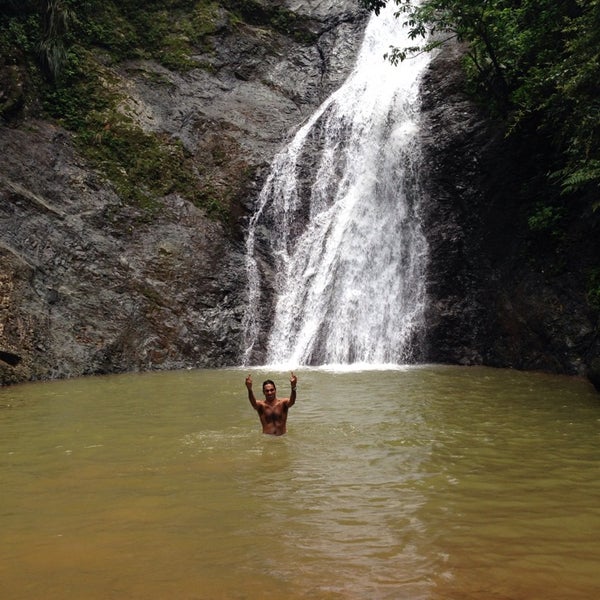 But also dialectisms. Since there are many peoples and cultures in Russia, there are more than 250 thousand of them. Not surprisingly, even native speakers sometimes need to find the exact meanings of words. This can be done using explanatory dictionaries or a special WordMap service.
Why is such a platform convenient? This is a clear and simple dictionary of word meanings, which is proposed to be used online. The service allows:
- to find out the exact meaning of a word or idiom;
- determine its correct spelling;
- to understand how to properly emphasize it.
The site offers to get acquainted with the history of the word. It tells what language or culture it came from, when and by whom it was used in speech.
When looking up the meaning of words in a dictionary, it is important to understand its essence. After all, the sound component of each lexical unit in the language is inextricably linked with certain objects or phenomena. That is why when using the service, you should not put an equal sign between the meaning of the searched word and its concept. They are interconnected, but they are not a single whole. For example, the concept of the word “center” can be defined as the middle of something. However, specific meanings can indicate the interior of a room, a city, a geometric figure, etc. Sometimes it refers to a medical organization, mathematics or mechanical engineering. Polysemy is the complexity of the Russian language.
Finding values through WordMap
In order to find out what a word means, painstaking work has been carried out. After all, different manuals and collections can give different meanings of the same lexical constructions. To get the most complete picture of the word, you should contact the WordMap service. The system contains values from the most popular and authoritative sources, including dictionaries:
- Ozhegov;
- Dahl;
- medical;
- cities;
- jargons;
- TSB, etc.

Thanks to this, you can find out not only all bookish, but also figurative meanings of a lexical construction.
Just searched:
with heat 2 seconds ago
alkane 2 seconds ago
kpset 3 seconds ago
maman 3 seconds ago
did not lead to anything good 4 seconds ago
did not lead to anything good 4 seconds ago
came off0003
DLSNAAK 6 seconds ago
AITERM 9 seconds ago
Onokilkhz 12 seconds ago
Payol 12 seconds ago
Bokrias 13 seconds ago
Lozvak 13 seconds ago
9000 2 seconds ago 9000
delay 15 seconds ago
Maricao, Puerto Rico – provinces, cities, time zones
Provinces
Bucarabones Barrio | Indera Fria Barrio Montoso Barrio |
Information about the region
| Region: | Maricao |
|---|---|
| Time zone: | America / Puerto Rico |
| GMT/UTC: | -4 hours |
| DST: | -4  hours |
*GMT/UTC – Coordinated Universal Time
*DST – Daylight Saving Time
Geographic information
| Latitude in degrees: | 18. 17301 |
|---|---|
| Longitude in degrees: | -66.94546 |
| Latitude in degrees, minutes and seconds: | 18° 10′ 23″ North |
| Longitude in degrees, minutes and seconds: | 66° 57′ 44″ W |
| Height above sea level: | 466 meters |
| Geographic feature: | A (Special feature of type Administrative region) |
| Geographic object code: | A.ADM1 (first order administrative division) |
*first-order administrative division – the primary administrative division of a country, such as a state in the United States
Cities in the region
Maricao | Hacienda Llanada |