Pueblo salinas puerto rico: Salinas, Puerto Rico – Town of the Islander Dip
Salinas, Puerto Rico
(sah-LEE-nahs)
Salinas is known as La Cuna del Mojito Isleño
(the cradle of the islander dip). Salinas was founded in 1841 by
Agustín Colón Pacheco.
Salinas is home of the Albergue Olímpico, an Olympic
training center. The facilities includes: the Puerto Rican Museum of Sports, a
botanical garden, several shops, and a Water Park. Open daily:
8:00am-10:00pm, (787) 824-2607.
ecard
Atardecer en Salinas I (Photo: Eileen Bonilla)
The Jobos Bay National Estuarine Research Reserve was established in 1987.
The reserve is located between the coasts of Salinas and Guayama, approximately
2,883 acres of mangrove forest and freshwater wetlands. The two main components:
Mar Negro mangrove forest, which consists of a mangrove forest and a complex
system of lagoons and channels interspersed with salt and mud flats; and Cayos
Caribe Islets, which are surrounded by coral reefs and seagrass beds, with small
beach deposits and upland areas. Open Daily: 8:00am-4:00pm, (787) 864-0105.
Guided tours are offered upon request andreservation.
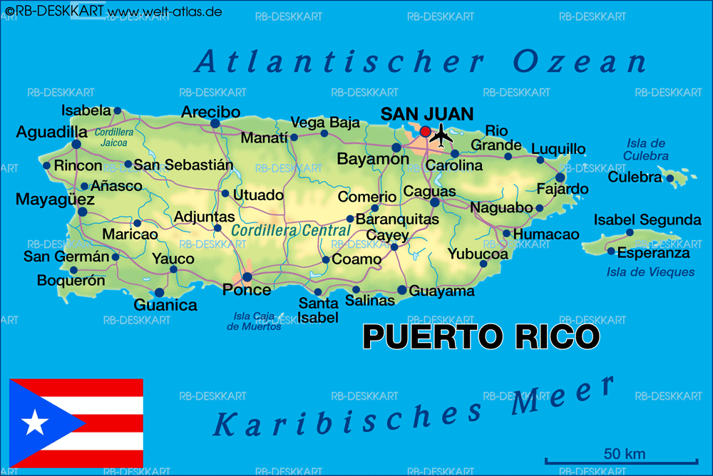
Salinas is located in the southern coast of the island,
south of Aibonito and Cayey; southeast of Coamo, east of Santa Isabel; and west
of Guayama.
The town is a fishing center and known for its seafood restaurants. The
surrounding areas produces sugar cane and salt.
There are many well-known salinenses, among them:
Antonio Ferre, and Agustin Colon Pacheco.
Salinas is made up of 8 barrios (wards/districts):
- Aguirre
- Coquí
- Lapa
- Palmas
- Pueblo
- Quebrada Yeguas
- Río Jueyes
- San Felipe
Things to See and Do In Salinas
Want to know what to see and do in Salinas?
Discover few ideas for exploring and enjoying the city.
What to Do and See?
Where to Eat?
Where to Stay?
Festivals and Events
- Carnaval Abey – February
- Festival del Pescao – June
- Fiestas Patronales Nuestra Senora de la Monserrate – September
Every year, Salinas celebrates a patron saint festival. The festivities include dances, food, parades and religious processions.
(787) 824-3060
 The festivities include dances, food, parades and religious processions.
Symbols
Anthem:
Salinas, Salinas…
Education
There are 20 public schools in Salinas,
education is handled by the Puerto Rico Department of Education.
Climate
10 Day Forecast
Demographics *
Population
25,789
Puerto Rico: 3,285,874
Land Area: 69.37 sq mi
Density: 398.2 per sq mi
Median Age: 42.1
Sex: 52% female
Economics **
Per capita income
$9,860
Puerto Rico: $21,058
Median household income: $17,694
Puerto Rico: $21,058
Persons below poverty line: 49.8%
Housing, families and educational attainment *
Number of households
9,973
Housing units density:
207.3 (2013)
Persons per household: 2.76
High school grad or higher: 74%
Marital status: 36% married
* U.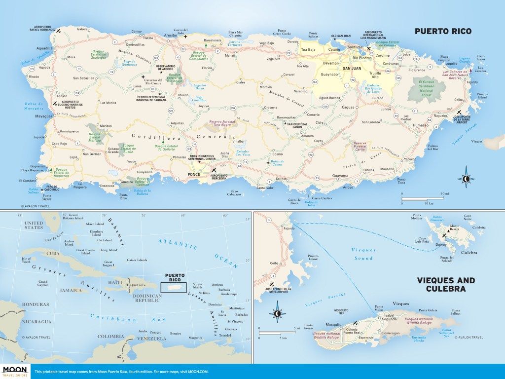 S. Census Bureau 2020 data, unless otherwise noted – Source: Quick Facts Puerto Rico.
** U.S. Census Bureau 2016-2020
Map References
Coordinates: 18.1144° N, 66.1681° W
Zip Code: 751
Driving Distance from San Juan: 53.4 miles
Driving Time: 1 hour, 16 minutes
Salinas
Salinas,Puerto Rico
Salinas is known as «The town of the Island Mojo» and its residents are called the Marlins. «Mojo» is a sauce that is used to marinate fried fish and is made from a base of tomato sauce, oil, garlic, bay leaves and onion. The patron saint of the municipality is the Virgin of Monserrate. The territory of Salinas covers approximately 69 square miles (180.4 kilometers). The population, according to the 2000 U.S. Census, is 31,113salinenses. The municipality is divided into the sectors of Salinas Pueblo, Aguirre, Lapa, Palmas, Quebrada Yeguas and Río Jueyes.
Sugar cane played a fundamental role in the development of Salinas. The cane was processed in the Aguirre Central sugar mill, one of the last to cease operations on the island. Today, Salinas has factories that produce plastic and metal products, electrical and electronic equipment, clothing, fruit drinks and frames for lenses and eyeglasses. Other industries include fruit orchards, raising livestock, and fishing. Tourism is another source of income for the municipality.
Geography
Salinas is located on the southern coast of Puerto Rico. It is bordered on the north by the municipalities of Coamo, Aibonito and Cayey, on the south by the Caribbean Sea, on the west by the municipalities of Coamo and Santa Isabel and on the east by Guayama.
Geographically, Salinas is part of the sub-region called the Ponce-Patillas alluvial plain in the southern coastal plain region, which is formed by the consolidation of the valleys that descend southward from the central mountain range and the Cayey range. This region is one of the driest in Puerto Rico. Despite that, Salinas is known for its agricultural wealth.
In the north, it has elevations that are part of the Cayey range, which many consider to be an extension of the central mountain range. The highest of these are Las Tetas peaks, at 2,756 feet (840 meters) above sea level. The next highest peaks are Los Soldados at 2,592 feet (790 meters), the highest point in the Jájome mountains at 2,395 feet (730 meters) and Los Cielos peak, which rises to 1,870 feet (570 meters) in elevation.
To the west, on the border with the municipality of Coamo, are the peaks of Modesto, Respaldo, Pío Juan and Cariblanco, or Cerro de la Bandera. To the east, on the border between the Quebrada Yeguas sector of Salinas and the Pozo Hondo sector of Guayama, rises the Garau peak at 438 meters (1,437 feet) above sea level.
A geological formation in Salinas is Las Piedras del Collado (The Stones of the Pass), popularly known as the Tetas de Cayey. This area was designated a nature reserve by law in September 2000. The designated area includes the two promontories, a segment of primary forest with species of significant ecological value, and a buffer zone, for a total area of 7.86 hectares.
The municipality’s hydrological system consists of the Salinas, Majada, Lapa and Jueyes rivers. The Salinas River forms in the Lapa sector and runs for 17 kilometers (10.5 miles) until it empties into the Caribbean Sea. Its tributaries are the Lapa River, which forms from the Pasto Viejo, Callao and La Palma streams, and the Majada River, which has as a tributary the Jájome River and is fed by the Carmen, Del Palo and De la Mina streams. The Jueyes River originates between Salinas and Coamo and is approximately 13 kilometers in length. Also within the municipality are the Brenes, Yeguas, Cerrillos, Amorós and Aguas Verdes streams. The last two of these form in the Aguirre sector and empty into Jobos Bay.
Another element worth mentioning is that the coast of Salinas, specifically the coast in the Aguirre sector, is low-lying and swampy with many lagoons.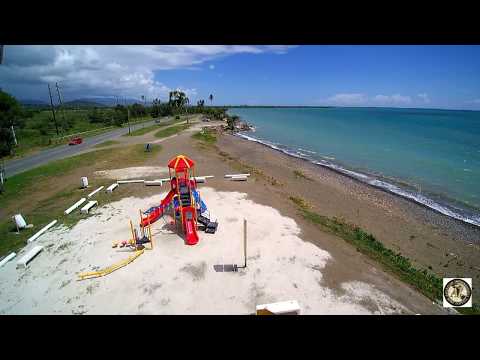 One of these is called Mar Negro, or Black Sea. The coast of the municipality includes Rincón Bay, Salinas Beach, Arenas Point, Mar Negro, Colchones Point and Rodeo Point. Along the coast there are also numerous keys, among them the Mata, Ratones, Pájaros and De la Barca keys. On the Mata, Ratones, Pájaros and De la Barca keys, as well as Arenas point and Mar Negro, are mangrove swamps populated with red mangroves. These cover an area of 180 hectares.
The municipality’s name comes from the huge mounds of salt that were found on its coasts. By the middle of the 17th century, the region was inhabited by residents who called the area Las Salinas. Fray Iñigo Abbad described the settlement in his account of 1776. Abbad reported that at that time there were 90 to 100 families in the Coamo parish «whose lands, although sandy and poor, are well cultivated and they harvest much coffee…» At that time, the area was a sector of Coamo and salt was already being produced.
There are documents in the archives of the Department of Public Works that indicate that on February 23, 1842, the residents of the area joined in an effort to obtain authorization to found a town and to share the costs of building the necessary municipal structures.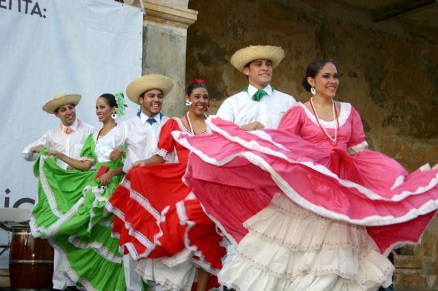 In those documents appears the name of Andrés Ortiz, a resident who offered to donate a cuerda of land for the town.
On July 15, 1847, Salinas was separated from Coamo and annexed to Guayama by royal order. The residents continued their efforts and on July 22, 1851, the town was finally founded. It consisted of the sectors Ausubos or Lapa, Collado, Palmas, Quebrada Yeguas, Quebrada Honda, Río Jueyes and Salinas Pueblo. In 1854, the governor of the diocese issued a decree declaring Salinas an independent parish, devoted to the Virgin of Monserrate.
Raising livestock was a common activity in 1878. There were also three sugar cane plantations with steam-powered machinery, one with an ox-powered cane press, and three coffee farms. In the same year, the sectors of Collado and Quebrada Honda disappeared and the Playas sector was created. On March 1, 1902, the Puerto Rico Legislative Assembly approved the law for the consolidation of certain municipal terms of Puerto Rico. The law ordered that the municipality of Salinas be abolished and its area annexed to Guayama.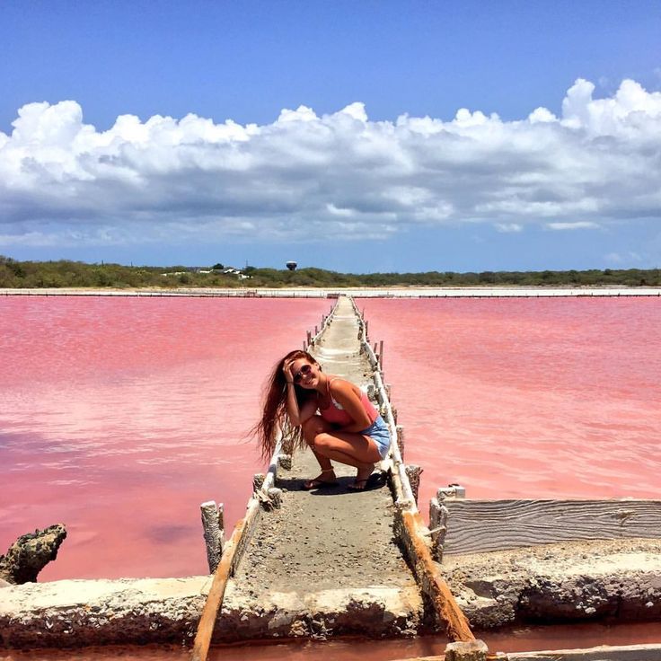 In 1905, the legislature repealed the law. Salinas once again became an independent municipality with the same sectors it had in 1902. In 1948, the Aguirre sector was divided into Central Aguirre (village), Coquí, San Felipe and Aguirre, and the size of the urban area increased. The Central Aguirre, Coquí and San Felipe sectors are small settlements in the rural Aguirre sector.
In the 1970s, Salinas was one of the most prosperous towns on the island, due to the size and volume of its sugar industry. At that time, the Aguirre mill was operated by the Puerto Rico Sugar Corporation.
Symbols
Flag
The flag is green with five white triangles that symbolize the mounds of salt that appear on the coat of arms and represent the municipality’s salt works.
Coat of Arms
The coat of arms contains the official colors of the municipality: green and silver. The mounds of salt depicted on the upper part of the seal graphically represent the name of the municipality.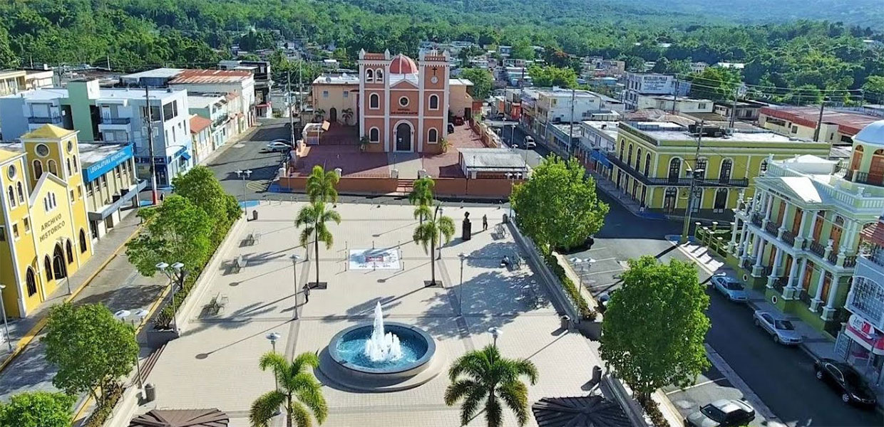 Meanwhile, the fish shown on the lower part allude to the importance of fishing in the region. The sugar cane branches that surround the seal symbolize the region’s sugar cane plantations.
Mayor
Hon. Carlos J. Rodríguez Mateo
Places of Interest
• Olympic Center
• Aguirre Forest
• Former Aguirre Central sugar mill
• Camp Santiago
• Museum of Sports
• Puerto Rico International Speedway
• Pozuelo Beach
• Freshwater well
• Jobos Bay Estuarine Research National Preserve
• Monument to Veterans
• Rincón Bay
• Artisans market
• Jagüeyes Forest
Illustrious Citizens
Jesús María Amadeo – Physician, novelist and playwright.
Rafael Esparra Cartagena – Public servant. In 1980, he was named special assistant to the Mayor of New York. In 1984 he was named deputy commissioner of the New York Fire Department and, in 1997, he became president of the Brooklyn Navy Yard Development. He has been recognized on various occasions for his professional and civic work.
Melvin Rodríguez Rodríguez – Painter and artist. His works focus on religious imagery. He has also created films, all of them made in Puerto Rico.
Events
• National Three Kings Day Procession – January
• Abey Carnival – February
• Fish Festival – June
• International Olympic Festival – June
• Island Mojo Festival – July
• Virgen de la Monserrate Patron Saint Festival – September
• Christmas Festival – December
Text taken from enciclopediapr.org
Video
Ayúdenos a describir todo lo que su municipio ofrece a las Industrías del Turismo y Negocios.
Favor enviar sus textos, fotografías y videos a:
havopaimo dar Salinas Barrio-Pueblo – peshgii daqiq va mufassal dar Salinas Barrio-Pueblo imruz, pagoh va hafta.
 Salinas Barrio Pueblo, Salinas, Puerto Rico
havopaimo dar Salinas Barrio Pueblo – peshgii daqiq wa mufassal dar Salinas Barrio Pueblo imruz, pago va khafta. Salinas Barrio Pueblo, Salinas, Puerto Rico
Obu havo dar nohiyai Salinas Barrio Pueblo
C
Salinas
havo dar 10
3
Rusy Salvador Sam Samoya Sharkӣ San Marino San Tome and Principi Bartalmo 9000 9000 9000 9000 9000 9000 9000 9000 9000. Northern Mariana Islands Seychelles Saint Martin Saint Pere and Miquelon Senegal Saint-Vincent and Grenadin St. Kits and Nevis Saint-Lusia Serbia Singapore Sint Marten 9000 9000 9000 9000 9000 9000 9000 9000 9000 9000 9000 9000 9000
0 9000
00 9000
00 9000
0 90000
0 90000 9000
0 90000
00 Solomon Islands
0 9000
0 90000
0 90000 9000
0 90000
00 Solomon Islands
0 9000
0 90000
00 Solomon Islands
0 Solomon Islands
Somalia Sudan Suriname Sierra Leone Thailand Thailand 0009
Salinas Barrio Pueblo
Salinas Barrio Pueblo is the Barrio and the administrative center (seat) of Salinas, municipality of Puerto Rico.