Radar doppler puerto rico: Puerto Rico Radar and Satellite
Fiona Live Radar Update: Hurricane Warning Puerto Rico Today
Sunday September 18
Morning Update
We start this day with Fiona still a tropical storm, but it is expected to intensify to a hurricane today before making landfall on Puerto Rico. On the satellite images we can see a developing eye in the center of circulation, showing better organization.
This development has increased the rainfall forecast. Puerto Rico will be seeing the worst conditions:
Storm Surge: 1 to 3 Feet!
Rainfall: 6 to 12 inches of rain likely, but southern parts of the island may see up to 25 inches enhanced by the mountains! Yes, over 2 feet of rainfall is possible with this storm in some spots! Devastating flooding, mudslides and widespread long lasting power outages are very possible.
Below is a live radar centered on Puerto Rico to plot and compare to the forecast maps.
Satellite Loop Saturday Morning
(The website has been having issues with some GIFs, so I have embedded this loop from my Twitter feed)
#Fiona satellite loop Sunday Morning.

This is expected to become a hurricane today as it crosses Puerto Rico.
Rainfall Forecast: 12 to 16 inches, UP TO 20 INCHES pic.twitter.com/A0N2fymCtz— Justin Berk (@JustinWeather) September 18, 2022

Snapshot Sunday Morning Set Up
Before sunrise, the center of the storm was located 80 miles south of St. Croix and 80 miles Southeast of Ponce, Puerto Rico.
The stronger side of the storm is on the RIGHT OF CENTER. This is the portion that will cross over Puerto Rico today!
Tropical Storm Fiona
Winds are 65 mph
Moving to the WNW 8 mph (slowed down from yesterday)
Tropical Storm Force Winds Extend 140 miles from the center
A weather station at Teagues Bay, St. Croix recently reported a wind gust of 59 mph (94 km/h). A wind gust of 55 mph (89 km/h) was recently reported at Henry E. Rohlsen Airport on St. Croix.
The estimated minimum central pressure based on earlier aircraft data is 994 mb (29.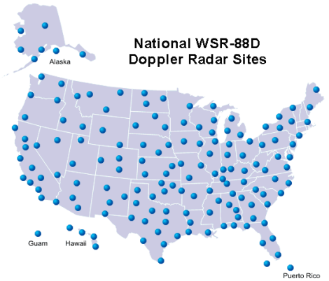 36 inches).
Forecast Track/Cone
From NOAA/National Hurricane Center
SUMMARY OF WATCHES AND WARNINGS IN EFFECT:
A Hurricane Warning is in effect for…
* Puerto Rico, including Vieques and Culebra
* The coast of the Dominican Republic from Cabo Caucedo to Cabo Frances Viejo
A Hurricane Watch is in effect for…
* U.S. Virgin Islands
* North coast of the Dominican Republic from Cabo Frances Viejo westward to Puerto Plata
A Tropical Storm Warning is in effect for…
* U.S. Virgin Islands
* British Virgin Islands
* North coast of the Dominican Republic from Cabo Frances Viejo westward to Puerto Plata
A Tropical Storm Watch is in effect for…
* South coast of the Dominican Republic west of Cabo Caucedo to Barahona
* Turks and Caicos Islands
* Southeastern Bahamas
LIVE RADAR WEATHER WIDGET
Compare to the forecast model plot below.
Forecast HWRF: Simulation Landfall around 2 PM
The stronger side of the storm is on the RIGHT OF CENTER. This is the portion that will cross over Puerto Rico today!
Note that this model had the track on Puerto Rico yesterday, while the NOAA forecast was west into the Dominican Republic. This has been the best performer.
FORECAST DETAILS:
RAINFALL: Fiona is forecast to produce the following rainfall:
Leeward Islands: Additional 2 inches or less.
British and U.S. Virgin Islands: 4 to 6 inches, maximum of 10 inches on St. Croix.
Puerto Rico: 12 to 16 inches with local maximum of 25 inches, particularly across eastern and southern Puerto Rico.
Northern and Eastern Dominican Republic: 4 to 8 inches with local maximum 12 inches, particularly near the far east coast.
Rest of Dominican Republic and Haiti: 1 to 3 inches.
Turks and Caicos: 3 to 6 inches.
These rains will produce life-threatening flash flooding and urban flooding across Puerto Rico and the eastern Dominican Republic, along with mudslides and landslides in areas of higher terrain.
STORM SURGE: The combination of storm surge and the tide will cause normally dry areas near the coast to be flooded by rising waters moving inland from the shoreline. The water could reach the following heights above ground somewhere in the indicated areas if onshore winds and the peak surge occur at the time of high tide…
Southern coast of Puerto Rico…1 to 3 ft
Vieques and Culebra…1 to 3 ft
U.S. Virgin Islands…1 to 2 ft
Forecast Intensity
There is NOW a lot more support for this to reach at least become a Category 2 Hurricane AFTER passing north of Puerto Rico.
Tropical Forecast Track/Cone
Wide View Forecast
Most ensembles show this curving through the Bahamas then east of the US coast towards Bermuda.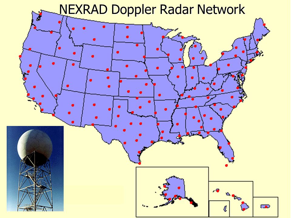 While it may miss the US east coast, it will produce dangerous rip currents and beach erosion through the Mid Atlantic shoreline.
INTERACTIVE WIND FORECAST: NHC Forecast
Use the slider at the bottom of the viewer to adjust the time. You can adjust the view to zoom in or pan the map.
Weather posts straight to your inbox
Sign up and be the first to know!
- Email Address*
EXPLORE MORE
Atlantic Tropical History: Maps of Origin Regions Every 10 Days
NOAA Study: Reducing Air Pollution INCREASED Tropical Storms
COMPARE TO THE PAST
If you want a snowy winter, this is what you might want to look for in the rest of the tropical season.
Record August For No Named Tropical Storms: Closer Look At Snow Following
Hurricane Season Forecast: June 1 Through November 30
NOAA 2022 Hurricane Forecast- Above Normal Again
Forecast From Colorado State University
Atlantic Hurricane Forecast
Please share your thoughts, best weather pics/videos, or just keep in touch via social media
STEM Assemblies/In School Fields Trips Are Back
Click to see more and ‘Book’ a visit to your school
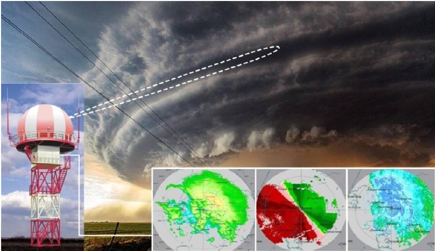
Puerto Rico Weather Radar Network
The Puerto Rico weather radar network in connection with CASA’s strategic plans, seeks to advance fundamental electromagnetic knowledge of the atmosphere and to provide societal benefits by improving the observation, detection and prediction of weather and climate phenomena in tropical environment and variable terrain. The network is composed of two different X-band weather radar networks in development/operation: namely CASA Student-Led OTG (Off-the-Grid) Radar Network and MRI Tropinet Radar Network. Both radar networks will operate in a collaborative and adaptive manner based on end users needs. An interdisciplinary team of students and faculty members from the CASA core partners and from areas such as electrical, computer and civil engineering, computer and social sciences and meteorology, works in the development of these networks. Development and operation of the weather radar networks is funded by the NSF Engineering Research Center CASA (for OTG radar network) and the NSF Major Research Instrumentation (MRI) Program (for Tropinet radar network).
Off-the-Grid Weather Radar Network
CASA is developing several radar network concepts based on low-cost radars. One of such concept has been deployed at western Puerto Rico in conjunction with CASA academic partner, the University of Puerto Rico-Mayaguez (UPRM), using a network of simple, single-polarization radars that are not dependent on existing infrastructure, operating using solar energy and ad-hoc wireless networks, and providing gap-filling data with improved temporal and spatial resolution.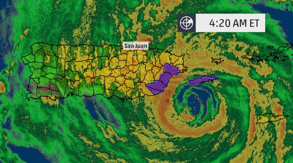 A team of CASA graduate and undergraduate students from several CASA partner institutions designed, assembled and installed an “Off-the-Grid” (OTG) solar-powered and wireless radar system in a region of western Puerto Rico that covers a crucial 1.5 km-high atmospheric weather-monitoring gap from the National Weather Service (NWS) Doppler radar in that mountainous region. This design grew entirely out of a student-led research project where the group of undergraduate and graduate students has led all aspects of this project. Thus, this project is innovative not only in radar network design, but also in the education of engineering students.
A proof-of-concept campaign of the OTG weather radar network design through deployment and experiments conducted in western Puerto Rico was coordinated by UPRM students and the NWS Office in San Juan. A network of three such radars was then operated during the Central American and Caribbean Games (CAC) in the summer of 2010 in conjunction with the US National Weather Service (NWS). Data from our test network was used to identify small-scale rain cells with better temporal and spatial resolution, and with lower-level coverage, than the operational NEXRAD installation in Puerto Rico. The key to retrieving such useful data was to configure the radars with overlapping coverage, operate them at short range, and use image mosaics to improve the data quality above what would be achieved with a single radar.
During 2011, talks were given at different venues based on the results obtained by operating the OTG network during the CAC summer games, resulting in local and international interest in the OTG radar network concept. This “Off-the-Grid” (OTG) concept is one that might provide a means to monitor rainfall and provide useful data in those regions of the world where it is not feasible or cost-effective to deploy more costly, and more accurate, radars. Moreover, this project has potentially significant implications for the future of meteorology, and also provides value to the engineering students who are gaining real-world, hands-on experience in providing state-of-the-art technical services in an international setting, with very little supervision. For more information on the CASA OTG project please visit http://stb.ece.uprm.edu/.
Tropinet Weather Radar Network
An NSF MRI grant was awarded to UPRM for the development of a network of three short range dual polarized X-band Doppler radars. The Tropinet network will provide the capabilities for studying and understanding weather phenomena in the Puerto Rico tropical and mountainous environment with the necessary volume coverage and resolution. The radars were designed to operate in a collaborative network capable of targeting an event from multiple angles, to accurately estimate rainfall levels near the ground, and to detect precursors of future storms, all in response to changing end-user needs as demonstrated in the CASA IP1/IP5 radar network.
The radars are being developed in a collaborative manner between CASA academic partners Colorado State University (CSU) and UPRM.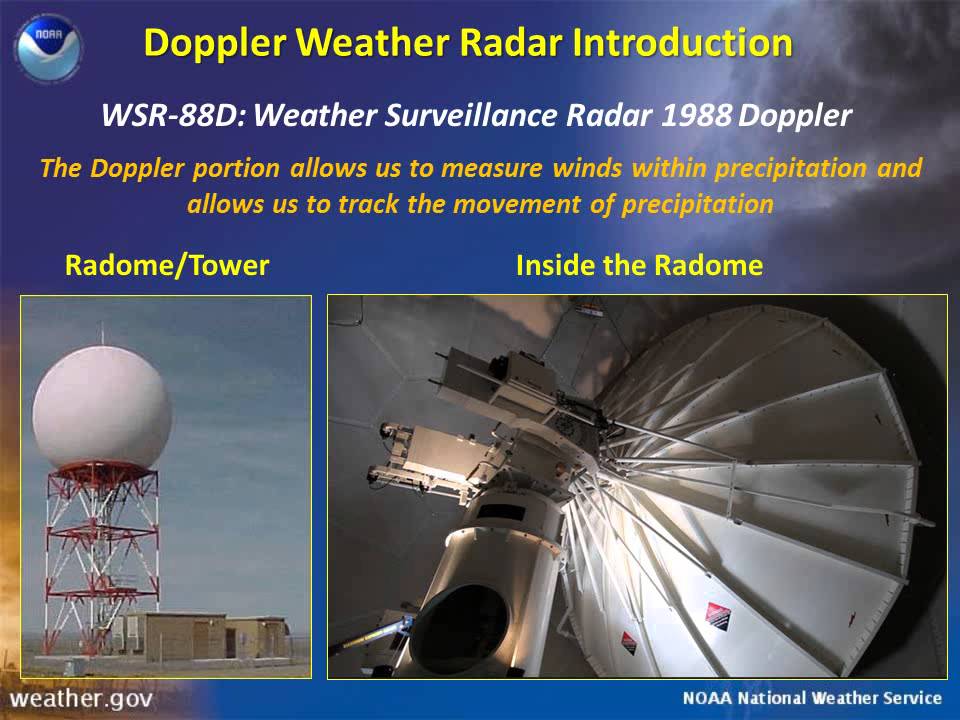 A Managing System Control and Decision Center (MSCDC) which is an integral part of the operation of the system will be developed in collaboration with University of Massachusetts Amherst (UMass). The first radar node of the Tropinet network was installed in March 2012 and site preparations are underway for the installation of the other two nodes that will comprise the Tropinet weather radar network. It is expected that the Tropinet network will cover the lowest part of the atmosphere and will supplement the current NOAA/NWS S-band radar coverage. Data from the Tropinet network will be used to perform the on-site data quality assessment and calibration of the OTG radar network.
This project will provide opportunities in a new area of research and research training through increase interaction between students and faculty from UPRM, CSU, UMass and the National Weather Service. A significant outcome of this project will be the hands-on training that faculty, graduate and undergraduate students from UPRM will have in the construction, operation, calibration, and eventually research activities derived from the data analysis of this network.